METAR & TAF KALS
Current METAR
Observed 09:52Z
KALS 270952Z AUTO 00000KT 10SM FEW120 15/12 A3036 RMK AO2 SLP155 T01500122 $
- Wind
- 000° @ 0 kt
- Visibility
- 10 SM
- Temp / Dew
- 15°C / 12°C
- Altimeter
- 30.36 inHg
- Clouds
- FEW
- Density alt
- 8,804 ft
- Ceiling
- Unlimited
- Rules
- VFR
Airport info & contacts
Manager on record, flight service, ARTCC, attendance schedule and pattern altitude — published by the FAA and refreshed every 28 days.
Location
- From city
- 2 NM S
- VFR sectional
- DENVER
- ARTCC
- ZDV · DENVER
- NOTAM facility
- ALS (NOTAM-D)
Airport manager
- Name
- SIRAH MASTERS
- Phone
- 719-587-5211
- Address
- 2490 STATE AVE, ALAMOSA CO 81101
Flight service · Hours
- FSS DEN
- DENVER1-800-WX-BRIEF
- Attendance
- 0800-1930
Frequencies
Tap any row to copy the frequency to your clipboard.
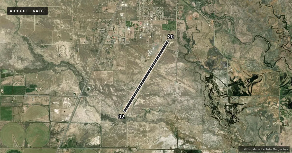
Runways & pattern
Full pagePattern entry · RWY 02
LEFT TRAFFICRunway end performance
| End | TORA | TODA | ASDA | LDA | VGSI | Approach lights | Obstruction |
|---|---|---|---|---|---|---|---|
| 02 | 8,519' | 8,519' | 8,519' | 8,519' | PAPI 4-box left(3°) | MALSR | — |
| 20 | 8,519' | 8,519' | 8,519' | 8,519' | VASI 4-box left(3°) | — | 40', tree, 1310' from thr, 15' R of cntrln, slope 27 |
Declared distances in feet. TORA = takeoff run available, TODA = takeoff distance, ASDA = accelerate-stop, LDA = landing distance.
Airport sketch
Runways drawn to scale from FAA survey coordinates, rendered over satellite imagery. Not for navigation.
Approaches & charts
ILS · 1
Services on the field
Fuel grades, oxygen, maintenance, ramp storage and lighting — as declared to the FAA by the airport operator.
Fuel & services
- Fuel
- 100LLA
- Oxygen (bottled)
- HIGH/LOW
- Oxygen (bulk)
- HIGH/LOW
- Airframe repair
- Major
- Power plant repair
- Major
- Other services
- AFRT,AGRI,AMB,AVNCS,CARGO,CHTR,INSTR
Ramp & ground
- Transient storage
- Tie-down
- Hangar
- Landing fee
- No fee published
- Customs
- Not available
- Lighting schedule
- SEE RMK
- Beacon schedule
- SS-SR
- Beacon
- White / Green (civil land)(WG)
- Wind indicator
- Lighted
- Segmented circle
- Yes
Fuel & FBOs
Cheapest 100LL and Jet A on the field and nearby. Always confirm with the FBO before taxi.
Airport notes
Surface conditions, obstructions, local procedures, lighting outages and other notes published with each FAA cycle.
General notes
- CONDS UNMON AT NGT AFT LAST ACR ARR TIL 0600; SEE NOTAMS FOR CONDS.
- FOR CD CTC DENVER ARTCC ON FREQ. IF UNA, CTC FSS ON FREQ VIA RCO. IF UNA, CTC DENVER ARTCC AT 303-651-4257.
- PPR FOR UNSKED AIR CARRIER OPNS CALL ARPT OPS 719-588-4881 OR 719-588-4871.
- ARFF COVERAGE PROVDD DURG ACR OPS; OTR TIMES 24 HR PPR - ARPT OPS 719-588-4881/4871.
- HOP ON & INVOF ARPT.
- COLD TEMPERATURE AIRPORT. ALTITUDE CORRECTION REQUIRED AT OR BELOW -25C.
- APRON GA RAMP CLSD TO ACRS.
Lighting notes
- ACTVT MALSR RWY 02; REIL RWY 20; VASI RWY 20; HIRL RWY 02/20 - CTAF 122.8
Runway surface & condition
- 02/20PCR VALUE: 392/F/C/X/T
Other notes
- 1ON CALL - 719-587-5335.
VFR map & nearby airports
VFR sectional. Tap any ICAO chip to open that airport.
Key facts · KALS
Answer card- ICAO
- KALS
- Name
- SAN LUIS VALLEY RGNL/BERGMAN FLD
- Location
- ALAMOSA, COLORADO
- Elevation
- 7,539.8 ft MSL
- Traffic pattern altitude
- 8,539.8 ft MSL (1,000 AGL)
- Control tower
- Non-towered (use CTAF)
- Total runways
- 1
- Longest runway
- 02/20 · 8,521 ft
- Published ILS approaches
- 1
- Published frequencies
- 2
- Magnetic variation
- 9°
- Current flight rules
- VFR
- Current wind
- 000° at 0 kt
- Favored runway now
- –
KALS is in Alamosa, Colorado. The field elevation is 7,539.8 ft MSL. It has one runway, 02/20, which is 8,521 ft long. There is no control tower. Pattern altitude is not published in the facts, so verify the current traffic pattern in the FAA Chart Supplement before you go. One ILS approach is available to runway 02. The airport sits in a high-altitude valley, so performance planning matters. Density altitude can be a real factor here, especially on warm days.
Centric Aviation is on the field. It carries 100LL and Jet A. Published remarks say runway 02 has MALSR lighting. Runway 20 has REILs and a VASI. High intensity runway lighting is available on both ends. The airport also notes that conditions are unmonitored at night after the last aircraft arrival until 0600, so check NOTAMs before a late arrival. This is a cold temperature airport too. Altitude correction is required at or below minus 25 degrees Celsius. For clearance delivery, use Denver Center on frequency. If that is not available, use Flight Service through the remote communications outlet or call Denver Center directly. The airport is in the San Luis Valley, so expect high terrain awareness to be part of the brief.