METAR & TAF N24
Current METAR
Observed 19:35Z
KN24 241935Z AUTO 34008KT 10SM VCTS CLR 30/03 A3040 RMK AO2 LTG DSNT NE THRU S T03000029
- Wind
- 340° @ 8 kt
- Visibility
- 10 SM
- Temp / Dew
- 30°C / 3°C
- Altimeter
- 30.40 inHg
- Clouds
- CLR
- Density alt
- 10,740 ft
- Ceiling
- Unlimited
- Rules
- VFR
Airport info & contacts
Manager on record, flight service, ARTCC, attendance schedule and pattern altitude — published by the FAA and refreshed every 28 days.
Location
- From city
- 6 NM N
- VFR sectional
- DENVER
- ARTCC
- ZDV · DENVER
- NOTAM facility
- N24 (NOTAM-D)
Airport manager
- Name
- JACOB LAFORE
- Phone
- 575-497-5710
- Address
- PO BOX 260, QUESTA NM 87556-0260
Flight service · Hours
- FSS ABQ
- ALBUQUERQUE1-800-WX-BRIEF
- Attendance
- Unattended
Frequencies
Tap any row to copy the frequency to your clipboard.
Runways & pattern
Full pagePattern entry · RWY 35
LEFT TRAFFICRunway end performance
| End | TORA | TODA | ASDA | LDA | VGSI | Approach lights | Obstruction |
|---|---|---|---|---|---|---|---|
| 17 | — | — | — | — | PAPI 4-box right(3°) | — | — |
| 35 | — | — | — | — | PAPI 4-box left(3°) | — | — |
Declared distances in feet. TORA = takeoff run available, TODA = takeoff distance, ASDA = accelerate-stop, LDA = landing distance.
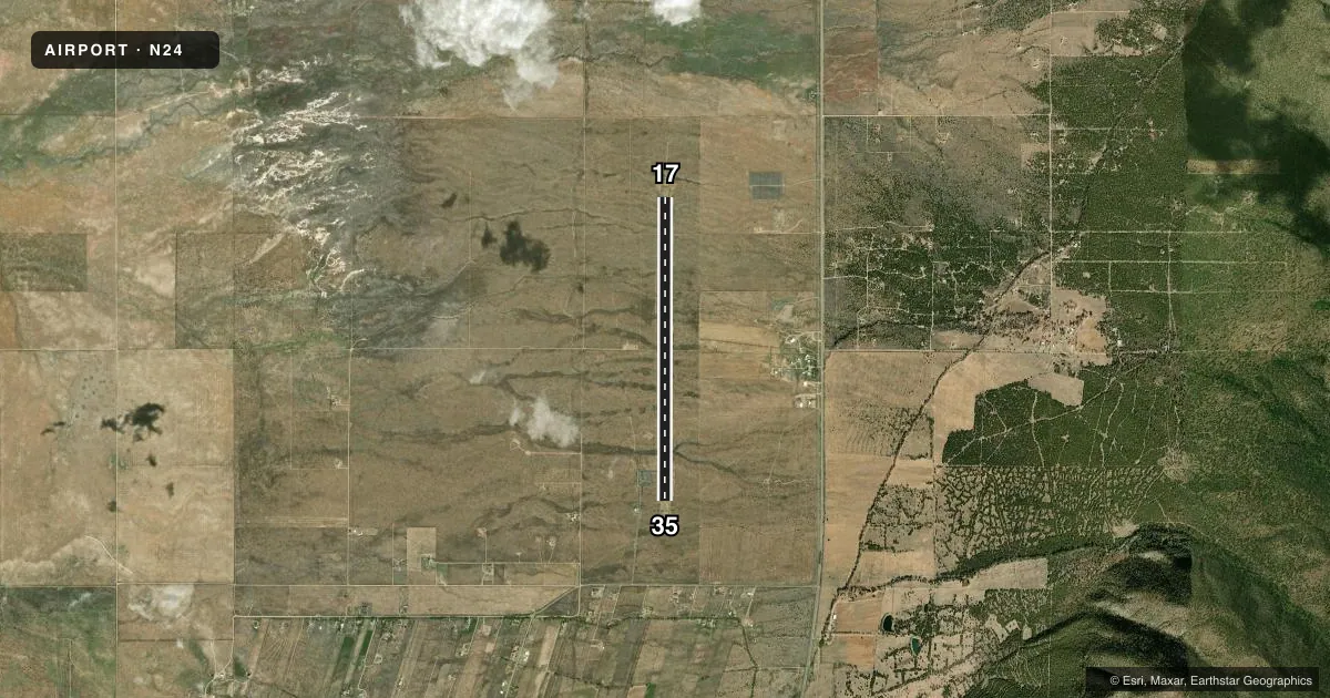
Airport sketch
Runways drawn to scale from FAA survey coordinates, rendered over satellite imagery. Not for navigation.
Approaches & charts
Services on the field
Fuel grades, oxygen, maintenance, ramp storage and lighting — as declared to the FAA by the airport operator.
Fuel & services
- Fuel
- Not available
Ramp & ground
- Transient storage
- Tie-down
- Lighting schedule
- SEE RMK
- Beacon schedule
- SS-SR
- Beacon
- White / Green (civil land)(WG)
- Wind indicator
- Yes
- Segmented circle
- Yes
Fuel & FBOs
Cheapest 100LL and Jet A on the field and nearby. Always confirm with the FBO before taxi.
Airport notes
Surface conditions, obstructions, local procedures, lighting outages and other notes published with each FAA cycle.
General notes
- ELK ON & INVOF ARPT.
- GATE CODE 7670.
- MTS SW & E.
- FOR CD CTC DENVER ARTCC AT 303-651-4257.
Lighting notes
- ACTVT REIL RWY 17 & 35; PAPI RWY 17 & 35; MIRL RWY 17/35 - 123.6.
Approach & departure obstructions
- 171-3 FT BRUSH, 0-200 FT DIST, 80 FT L/R.
- 17CALM WIND RWY.
- 17RWY 17 NRS & CNTRLN FADED OR MISG.
- 35RWY 35 NRS AND CNTRLN FADED OR MISG.
Other notes
- THIS AIRPORT HAS BEEN SURVEYED BY THE NATIONAL GEODETIC SURVEY.
- MANAGEREMER CTC FONE: 575-613-2853 DON CASAUS-OPER.
VFR map & nearby airports
VFR sectional. Tap any ICAO chip to open that airport.
Key facts · N24
Answer card- ICAO
- N24
- Name
- QUESTA MUNI NR 2
- Location
- QUESTA, NEW MEXICO
- Elevation
- 7,689.6 ft MSL
- Traffic pattern altitude
- 8,689.6 ft MSL (1,000 AGL)
- Control tower
- Non-towered (use CTAF)
- Total runways
- 1
- Longest runway
- 17/35 · 6,861 ft
- Published ILS approaches
- 0
- Published frequencies
- 1
- Magnetic variation
- 11°
- Current flight rules
- VFR
- Current wind
- 340° at 8 kt
- Favored runway now
- RWY 35
Questa Muni Nr 2 sits in Questa, New Mexico. The field elevation is 7,689.6 ft MSL. It has one runway, 17/35, which is 6,861 ft long and asphalt. There is no control tower. No ILS approaches are published. The published pattern altitude is not listed, so use standard traffic pattern practice for light piston aircraft unless the current Chart Supplement says otherwise.
Runway 17 is the calm wind runway. The runway lights are medium intensity. REIL and PAPI are published on both ends. The runway numbers and centerline are faded or missing on both 17 and 35, so plan for a careful visual setup on arrival and departure. Brush is reported near runway 17 from the threshold area out to 200 ft, about 80 ft left and right of the runway. Elk are also reported on and near the airport. Mountains are southwest and east, so terrain awareness matters here, especially with the high field elevation.
There are no on-field FBOs listed. Contact the airport operator directly before arrival if you need fuel or ramp details. For clearance delivery, the Chart Supplement says to contact Denver ARTCC. CTAF is 122.9. The lighting note also lists common traffic advisory frequency as 123.6. Verify the current frequency in the Chart Supplement before flight.