METAR & TAF 05V
05V does not publish a METAR.
Showing the nearest reporting station: KALS (SAN LUIS VALLEY RGNL/BERGMAN FLD) · 15.1 NM away. Conditions at 05V may differ.
METAR · KALS
Observed 10:52Z
KALS 271052Z AUTO 00000KT 10SM CLR 14/12 A3035 RMK AO2 SLP159 T01440122 $
- Wind
- 000° @ 0 kt
- Visibility
- 10 SM
- Temp / Dew
- 14°C / 12°C
- Altimeter
- 30.35 inHg
- Clouds
- CLR
- Density alt
- 8,920 ft
- Ceiling
- Unlimited
- Rules
- VFR
Airport info & contacts
Manager on record, flight service, ARTCC, attendance schedule and pattern altitude — published by the FAA and refreshed every 28 days.
Location
- From city
- 3 NM SW
- VFR sectional
- DENVER
- ARTCC
- ZDV · DENVER
- NOTAM facility
- DEN (NOTAM-D)
Airport manager
- Name
- MYRRL SMITH
- Phone
- 719-379-3603
- Address
- BOX 6, BLANCA CO 81123
Flight service · Hours
- FSS DEN
- DENVER1-800-WX-BRIEF
- Attendance
- Unattended
Frequencies
Tap any row to copy the frequency to your clipboard.
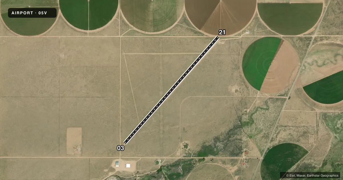
Runways & pattern
Full pagePattern entry · RWY 03
LEFT TRAFFICRunway end performance
| End | TORA | TODA | ASDA | LDA | VGSI | Approach lights | Obstruction |
|---|---|---|---|---|---|---|---|
| 03 | — | — | — | — | — | — | 10', road, 0' from thr, 0' R of cntrln, slope 0 |
| 21 | — | — | — | — | — | — | 10', road, 0' from thr, 0' R of cntrln, slope 0 |
Declared distances in feet. TORA = takeoff run available, TODA = takeoff distance, ASDA = accelerate-stop, LDA = landing distance.
Airport sketch
Runways drawn to scale from FAA survey coordinates, rendered over satellite imagery. Not for navigation.
Approaches & charts
Services on the field
Fuel grades, oxygen, maintenance, ramp storage and lighting — as declared to the FAA by the airport operator.
Fuel & services
- Fuel
- Not available
- Oxygen (bottled)
- Not available
- Oxygen (bulk)
- Not available
- Airframe repair
- Not available
- Power plant repair
- Not available
Ramp & ground
- Transient storage
- Not published
- Landing fee
- No fee published
- Customs
- Not available
- Wind indicator
- Yes
- Segmented circle
- No
Fuel & FBOs
Cheapest 100LL and Jet A on the field and nearby. Always confirm with the FBO before taxi.
Airport notes
Surface conditions, obstructions, local procedures, lighting outages and other notes published with each FAA cycle.
General notes
- UNLIMITED VEHICLE ACCESS TO FIELD; WILDLIFE ON & INVOF ARPT.
- RY 21 HAS +15 FT SPRINKLER WITHIN 200 FT OF THLD; INTERMITTENTLY.
- RY 03 +35 FT POLE 475 FT FM RY END 50 FT R OF CNTRLN; +5 FT FENCE 10 FT FM THLD 0B; +15 FT BLDG 560 FT FM THLD 225 FT R OF CNTRLN; +15 FT BLDG 500 FT FM THLD 150 FT L OF CNTRLN.
- RY 03/21 SOFT WHEN WET.
- RY 21 +20 FT HANGAR 185 FT L OF THLD AND +8 FT ROAD 213 FT FM THLD 0B.
- RY 03/21 HAS 6 TO 12 IN DIRT WINDROWS ALONG BOTH SIDES FULL LENGTH.
- BE ALERT; INTENSIVE USAF STUDENT TRAINING IN VICINITY OF COLORADO SPRINGS & PUEBLO COLORADO.
- FOR CD CTC DENVER ARTCC AT 303-651-4257.
Other notes
- EXISTED PRIOR TO 1959.
- 03/211 TO 2 FT VEGETATION BOTH SIDES OF RY FULL LENGTH.
VFR map & nearby airports
VFR sectional. Tap any ICAO chip to open that airport.
Key facts · 05V
Answer card- ICAO
- 05V
- Name
- BLANCA
- Location
- BLANCA, COLORADO
- Elevation
- 7,720 ft MSL
- Traffic pattern altitude
- 8,720 ft MSL (1,000 AGL)
- Control tower
- Non-towered (use CTAF)
- Total runways
- 1
- Longest runway
- 03/21 · 6,160 ft
- Published ILS approaches
- 0
- Published frequencies
- 1
- Magnetic variation
- 11°
- Current flight rules
- VFR
- Current wind
- 000° at 0 kt
- Favored runway now
- –
BLANCA is in Blanca, Colorado. The field sits at 7,720 ft MSL. It has one runway, 03/21, which is 6,160 ft long and surfaced with dirt. This is an uncontrolled airport with no tower. CTAF is 122.9. No ILS approaches are published here.
The pattern altitude is not published. Use standard 1,000 ft AGL for light piston operations unless the current Chart Supplement says otherwise. At this elevation, performance planning matters. The runway is soft when wet. The published remarks also call out vegetation along both sides of the runway, plus dirt windrows on both sides for the full length. Runway 03 has several obstacles near the departure end. Runway 21 has a hangar and a road near the threshold area. Wildlife is reported on and near the airport. Vehicle access is unrestricted.
There are no on-field FBOs listed. Check with the airport operator or call the field on CTAF for current services before you go. The remarks also note intensive USAF student training in the Colorado Springs and Pueblo area. Expect busy training traffic in the region. For clearance delivery, contact Denver ARTCC at 303-651-4257.