METAR & TAF 1V8
1V8 does not publish a METAR.
Showing the nearest reporting station: KRCV (ASTRONAUT KENT ROMINGER) · 15.1 NM away. Conditions at 1V8 may differ.
METAR · KRCV
Observed 11:55Z
KRCV 271155Z AUTO 26009G15KT 10SM CLR 15/12 A3040 RMK AO2 T01490116 10171 20149
- Wind
- 260° @ 9G15 kt
- Visibility
- 10 SM
- Temp / Dew
- 15°C / 12°C
- Altimeter
- 30.40 inHg
- Clouds
- CLR
- Density alt
- 8,826 ft
- Ceiling
- Unlimited
- Rules
- VFR
Airport info & contacts
Manager on record, flight service, ARTCC, attendance schedule and pattern altitude — published by the FAA and refreshed every 28 days.
Location
- From city
- 4 NM NE
- VFR sectional
- DENVER
- ARTCC
- ZDV · DENVER
- NOTAM facility
- DEN (NOTAM-D)
Airport manager
- Name
- WENDI MAEZ
- Phone
- 719-655-2554
- Address
- P.O. BOX 476, SAGUACHE CO 81149
Flight service · Hours
- FSS DEN
- DENVER1-800-WX-BRIEF
- Attendance
- Unattended
Frequencies
Tap any row to copy the frequency to your clipboard.
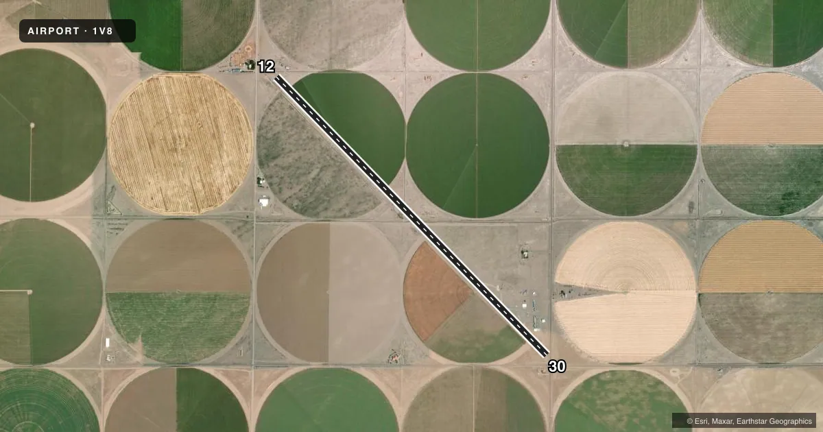
Runways & pattern
Full pagePattern entry · RWY 30
LEFT TRAFFICRunway end performance
| End | TORA | TODA | ASDA | LDA | VGSI | Approach lights | Obstruction |
|---|---|---|---|---|---|---|---|
| 12 | — | — | — | — | — | — | 55', trees, 507' from thr, 108' R of cntrln, slope 5 |
| 30 | — | — | — | — | PAPI 2-box left | — | — |
Declared distances in feet. TORA = takeoff run available, TODA = takeoff distance, ASDA = accelerate-stop, LDA = landing distance.
Airport sketch
Runways drawn to scale from FAA survey coordinates, rendered over satellite imagery. Not for navigation.
Approaches & charts
Services on the field
Fuel grades, oxygen, maintenance, ramp storage and lighting — as declared to the FAA by the airport operator.
Fuel & services
- Fuel
- 100LL
- Oxygen (bottled)
- Not available
Ramp & ground
- Transient storage
- Tie-down
- Hangar
- Landing fee
- No fee published
- Customs
- Not available
- Lighting schedule
- SEE RMK
- Beacon schedule
- SS-SR
- Beacon
- White / Green (civil land)(WG)
- Wind indicator
- Yes
- Segmented circle
- No
Fuel & FBOs
Cheapest 100LL and Jet A on the field and nearby. Always confirm with the FBO before taxi.
Airport notes
Surface conditions, obstructions, local procedures, lighting outages and other notes published with each FAA cycle.
General notes
- RY 12/30 HAS +12 FT SPRINKLERS ALONG BOTH SIDES OF RY 54 FT FROM CNTRLN FULL LENGTH OF RY.
- FOR CD CTC DENVER ARTCC AT 303-651-4257.
Lighting notes
- ACTVT LIRL RY 12/30 - CTAF.
Approach & departure obstructions
- 12RY 12 HAS -5 FT DITCH 120 FT FROM PAVEMENT END, +2 FT BERM 126 FT FROM PAVEMENT END.
- 30RY 30 HAS +60 FT POWER LINE & +4 FT SNOW FENCE AT PAVEMENT END.
- 12RY 12 HAS 135 FT NIGHTTIME DSPLCD THLD.
- 12RY MKGS WORN & FADED.
- 30RY MKGS WORN & FADED.
- 12RY 12 APCH SLOPE 20:1 TO DSPLCD THLD.
- 30RY 30 APCH SLOPE 21:1 TO DSPLCD THLD.
Other notes
- OBSTN REMOVAL OR THR DSPLCMT.
VFR map & nearby airports
VFR sectional. Tap any ICAO chip to open that airport.
Key facts · 1V8
Answer card- ICAO
- 1V8
- Name
- LEACH
- Location
- CENTER, COLORADO
- Elevation
- 7,598 ft MSL
- Traffic pattern altitude
- 8,598 ft MSL (1,000 AGL)
- Control tower
- Non-towered (use CTAF)
- Total runways
- 1
- Longest runway
- 12/30 · 7,000 ft
- Published ILS approaches
- 0
- Published frequencies
- 2
- Magnetic variation
- 12°
- Current flight rules
- VFR
- Current wind
- 260° at 9 kt
- Favored runway now
- RWY 30
LEACH (1V8) sits in Center, Colorado at 7,598 ft MSL. It has one runway. Runway 12/30 is 7,000 ft asphalt. There is no control tower. CTAF and UNICOM are both 122.8. No ILS approaches are published here.
Pattern altitude is not published. Use standard pattern planning if appropriate for your aircraft. Verify the current Chart Supplement before you go. The field is high elevation, so expect density altitude to matter on warm days. Runway 12/30 has low intensity lights that are activated by CTAF. The runway markings are reported as worn and faded on both ends. Published remarks also note a displaced threshold on runway 12 at night. Runway 12 has a 135 ft nighttime displaced threshold. Runway 30 has obstacle issues near the pavement end, including a power line and a snow fence.
Alpine Aviation is on the field. It carries 100LL. For clearance delivery, contact Denver ARTCC at 303-651-4257. The runway environment has multiple obstructions and slope issues near both ends. A first-time pilot should brief the Chart Supplement carefully and plan for the elevation, the runway lighting setup and the displaced threshold details before arrival.