METAR & TAF KANK
Current METAR
Observed 13:15Z
KANK 271315Z AUTO 25007KT 9SM FEW150 14/13 A3037 RMK AO2 T01390127 $
- Wind
- 250° @ 7 kt
- Visibility
- 9 SM
- Temp / Dew
- 14°C / 13°C
- Altimeter
- 30.37 inHg
- Clouds
- FEW
- Density alt
- 8,651 ft
- Ceiling
- Unlimited
- Rules
- VFR
Airport info & contacts
Manager on record, flight service, ARTCC, attendance schedule and pattern altitude — published by the FAA and refreshed every 28 days.
Location
- From city
- 2 NM W
- VFR sectional
- DENVER
- ARTCC
- ZDV · DENVER
- NOTAM facility
- DEN (NOTAM-D)
Airport manager
- Name
- ZECHARIAH PAPP
- Phone
- (719) 239-1648
- Address
- 9255 COUNTY ROAD 140, SALIDA CO 81201
Flight service · Hours
- FSS DEN
- DENVER1-800-WX-BRIEF
- Attendance
- WED-SUN · 0800-1700
Frequencies
Tap any row to copy the frequency to your clipboard.
Runways & pattern
Full pagePattern entry · RWY 24
LEFT TRAFFICRunway end performance
| End | TORA | TODA | ASDA | LDA | VGSI | Approach lights | Obstruction |
|---|---|---|---|---|---|---|---|
| 06 | — | — | — | — | PAPI 2-box left(3.5°) | — | 32', road, 850' from thr, 24' R of cntrln, slope 20 |
| 24 | — | — | — | — | PAPI 2-box left(3°) | — | — |
Declared distances in feet. TORA = takeoff run available, TODA = takeoff distance, ASDA = accelerate-stop, LDA = landing distance.
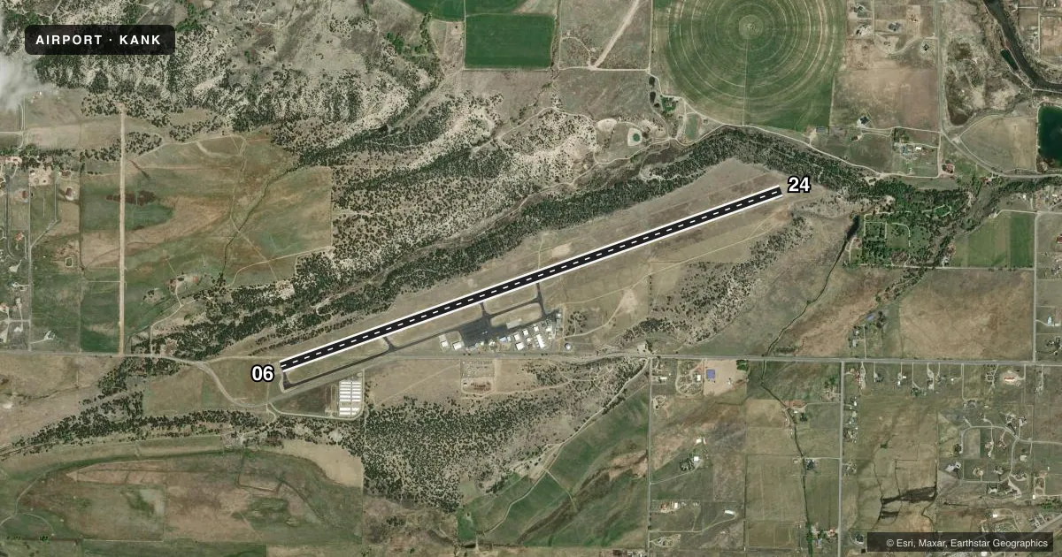
Airport sketch
Runways drawn to scale from FAA survey coordinates, rendered over satellite imagery. Not for navigation.
Approaches & charts
Services on the field
Fuel grades, oxygen, maintenance, ramp storage and lighting — as declared to the FAA by the airport operator.
Fuel & services
- Fuel
- 100LLA+
- Oxygen (bottled)
- Not available
- Other services
- AMB
Ramp & ground
- Transient storage
- Tie-down
- Landing fee
- No fee published
- Customs
- Not available
- Lighting schedule
- SEE RMK
- Beacon schedule
- SS-SR
- Beacon
- White / Green (civil land)(WG)
- Wind indicator
- Lighted
- Segmented circle
- Yes
Fuel & FBOs
Cheapest 100LL and Jet A on the field and nearby. Always confirm with the FBO before taxi.
Airport notes
Surface conditions, obstructions, local procedures, lighting outages and other notes published with each FAA cycle.
General notes
- RY 24 HAS 365 FT UNLIGHTED SMOKESTACK 5082 FT FM THLD 2500 FT R OF CNTRLN.
- DURING HIGH WIND CONDITIONS DOWNDRAFTS APPROACHING RY 24.
- RY 24 RECOMMENDED FOR LANDING; RY 06 FOR DEPARTURE WEATHER & TRAFFIC PERMITTING.
- RY 06 +60 FT POWERLINE MARKED WITH ORANGE BALLS 630 FT FM THLD, 435 FT LEFT OF RY EXTDD CNTRLN.
- BE ALERT; INTENSIVE USAF STUDENT TRAINING IN VICINITY OF COLORADO SPRINGS & PUEBLO COLORADO.
- FOR CD CTC DENVER ARTCC AT 303-651-4257.
Lighting notes
- ACTVT PAPI RWY 06 & 24; MIRL RWY 06/24 - CTAF.
Fuel notes
- 100LLFUEL AVBL WITH CREDIT CARD.
Approach & departure obstructions
- 24PAPI DOES NOT PROVIDE OBSTACLE CLEARANCE BYD 2 NM FROM THRESHOLD, UNUSABLE BYD 2 NM.
Other notes
- OWNERCOUNTY CONTACT: ROBERT CHRISTIANSEN
VFR map & nearby airports
VFR sectional. Tap any ICAO chip to open that airport.
Key facts · KANK
Answer card- ICAO
- KANK
- Name
- SALIDA/HARRIETT ALEXANDER FLD
- Location
- SALIDA, COLORADO
- Elevation
- 7,523 ft MSL
- Traffic pattern altitude
- 8,523 ft MSL (1,000 AGL)
- Control tower
- Non-towered (use CTAF)
- Total runways
- 1
- Longest runway
- 06/24 · 7,351 ft
- Published ILS approaches
- 0
- Published frequencies
- 2
- Magnetic variation
- 9°
- Current flight rules
- VFR
- Current wind
- 250° at 7 kt
- Favored runway now
- RWY 24
Salida/Harriett Alexander Field sits in Salida, Colorado. The field elevation is 7,523 ft MSL. It has one runway. Runway 06/24 is 7,351 ft long with asphalt pavement. There is no control tower. CTAF and UNICOM are both 122.7. No ILS approaches are published. Pattern altitude is not published in the facts, so use the current Chart Supplement before you fly.
Harriet Alexander Field is the on-field FBO. It carries 100LL and Jet A Prist. Fuel is available with credit card. The airport is a high-elevation mountain field, so performance planning matters. Expect density altitude to be a real factor, especially on warm days. The published remarks also call out obstacle and wind issues. Runway 24 is the recommended landing runway when weather and traffic allow. Runway 06 is recommended for departure when weather and traffic allow. Be alert for downdrafts on runway 24 in high wind conditions. The field also notes nearby powerline and smokestack obstacles on the runway ends, so a current briefing before arrival is smart.