METAR & TAF KGUC
Current METAR
Observed 07:56Z
KGUC 270756Z AUTO 31003KT 10SM CLR 15/14 A3041 RMK AO2 SLP185 T01500144 $
- Wind
- 310° @ 3 kt
- Visibility
- 10 SM
- Temp / Dew
- 15°C / 14°C
- Altimeter
- 30.41 inHg
- Clouds
- CLR
- Density alt
- 8,915 ft
- Ceiling
- Unlimited
- Rules
- VFR
Airport info & contacts
Manager on record, flight service, ARTCC, attendance schedule and pattern altitude — published by the FAA and refreshed every 28 days.
Location
- From city
- 1 NM SW
- VFR sectional
- DENVER
- ARTCC
- ZDV · DENVER
- NOTAM facility
- GUC (NOTAM-D)
Airport manager
- Name
- RICHARD LAMPORT
- Phone
- (970) 642-7388
- Address
- 519 RIO GRANDE, GUNNISON CO 81230
Flight service · Hours
- FSS DEN
- DENVER1-800-WX-BRIEF
- Attendance
- 0600-2100
Frequencies
Tap any row to copy the frequency to your clipboard.
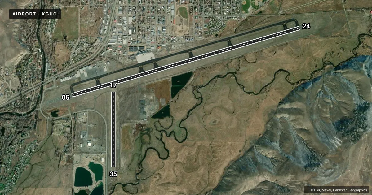
Runways & pattern
Full pagePattern entry · RWY 35
LEFT TRAFFIC| Runway | Heading (°M) | Length | Surface | Traffic |
|---|---|---|---|---|
| 06/24 | 62° / 242° | 9,400 ft | ASPH | 06 R |
| 17/35Favored | 168° / 348° | 2,981 ft | TURF-GRVL | 17 R |
Runway end performance
| End | TORA | TODA | ASDA | LDA | VGSI | Approach lights | Obstruction |
|---|---|---|---|---|---|---|---|
| 06 | 9,400' | 9,400' | 9,400' | 9,400' | PAPI 4-box left(3.2°) | MALSF | — |
| 24 | 9,400' | 9,400' | 9,400' | 9,400' | PAPI 4-box left(3.6°) | — | — |
| 17 | 2,981' | 2,981' | 2,981' | 2,981' | — | — | — |
| 35 | 2,981' | 2,981' | 2,981' | 2,748' | — | — | — |
Declared distances in feet. TORA = takeoff run available, TODA = takeoff distance, ASDA = accelerate-stop, LDA = landing distance.
Airport sketch
Runways drawn to scale from FAA survey coordinates, rendered over satellite imagery. Not for navigation.
Approaches & charts
ILS · 1
Services on the field
Fuel grades, oxygen, maintenance, ramp storage and lighting — as declared to the FAA by the airport operator.
Fuel & services
- Fuel
- 100LLA+
- Oxygen (bottled)
- Not available
- Oxygen (bulk)
- HIGH/LOW
- Airframe repair
- Not available
- Power plant repair
- Not available
- Other services
- AFRT,AMB,INSTR,SURV
Ramp & ground
- Transient storage
- Tie-down
- Hangar
- Landing fee
- No fee published
- Customs
- Not available
- Lighting schedule
- SEE RMK
- Beacon schedule
- SEE RMK
- Beacon
- White / Green (civil land)(WG)
- Wind indicator
- Lighted
- Segmented circle
- Yes
Fuel & FBOs
Cheapest 100LL and Jet A on the field and nearby. Always confirm with the FBO before taxi.
Airport notes
Surface conditions, obstructions, local procedures, lighting outages and other notes published with each FAA cycle.
General notes
- HIGH TRRN ALL QUADS.
- RWY 17/35 CLSD 1 DEC - 1 MAY.
- COLD TEMPERATURE AIRPORT. ALTITUDE CORRECTION REQUIRED AT OR BELOW -25C.
- MIGRATORY BIRD ACT 1 JAN -THRU- 1 JUN.
Lighting notes
- ROTG BCN OPERS SS-2230 & 0600-SR.
- ACTVT MALSF RWY 06; PAPI RWY 06 & 24 - CTAF. REIL RWY 24; HIRL RWY 06/24 OPER 0600-2230.
Runway surface & condition
- 06/24PCR VALUE: 410/F/B/X/T
Approach & departure obstructions
- 24PAPI UNUSBL BYD 2.5 NM; DOES NOT PRVD OBST CLNC BYD 2.5 NM FROM THR.
Other notes
- CLSD TO UNSKED ACR OPS WITH MORE THAN 30 PAX SEATS EXCP PPR. CALL AMGR 970-641-2304.
- 1ARPT CONDS UNMON AT NGT FM LAST ACR ARR/DEP TIL 0530 LCL. SEE NOTAMS FOR MOST UP-TO-DATE CONDS.
VFR map & nearby airports
VFR sectional. Tap any ICAO chip to open that airport.
Key facts · KGUC
Answer card- ICAO
- KGUC
- Name
- GUNNISON-CRESTED BUTTE RGNL
- Location
- GUNNISON, COLORADO
- Elevation
- 7,679.6 ft MSL
- Traffic pattern altitude
- 8,679.6 ft MSL (1,000 AGL)
- Control tower
- Non-towered (use CTAF)
- Total runways
- 2
- Longest runway
- 06/24 · 9,400 ft
- Published ILS approaches
- 1
- Published frequencies
- 2
- Magnetic variation
- 12°
- Current flight rules
- VFR
- Current wind
- 310° at 3 kt
- Favored runway now
- RWY 35
Gunnison-Crested Butte Rgnl sits in Gunnison, Colorado at 7,679.6 ft MSL. It has two runways. The longest is 06/24 at 9,400 ft. The airport is not towered, so expect self-announce traffic on CTAF 122.7. One ILS is published for runway 06. Pattern altitude is not published in the facts. Use the standard 1,000 ft AGL for light piston unless the current FAA Chart Supplement says otherwise.
Avflight Gunnison is on the field. It carries 100LL, Jet A and Jet A Prist. The airport is a high-elevation field with high terrain in all quadrants. That matters on climb performance and on arrival planning. The published remarks also call out cold temperature correction at or below minus 25 C. Check performance numbers carefully in winter.
Runway 06/24 has lighting notes that matter at night. MALSR is on 06. PAPI on 06 and 24 is controlled by CTAF. REIL is on 24. The high intensity runway lights on 06/24 operate from 0600 to 2230. Airport conditions are unmonitored at night from the last arrival or departure until 0530 local. Check NOTAMs before a late arrival. Runway 17/35 is closed from December 1 through May 1.