METAR & TAF 99V
99V does not publish a METAR.
Showing the nearest reporting station: KMTJ (MONTROSE RGNL) · 16.6 NM away. Conditions at 99V may differ.
METAR · KMTJ
Observed 09:53Z
KMTJ 270953Z AUTO 14010KT 10SM CLR 19/15 A3022 RMK AO2 SLP132 T01940150
- Wind
- 140° @ 10 kt
- Visibility
- 10 SM
- Temp / Dew
- 19°C / 15°C
- Altimeter
- 30.22 inHg
- Clouds
- CLR
- Density alt
- 8,131 ft
- Ceiling
- Unlimited
- Rules
- VFR
Airport info & contacts
Manager on record, flight service, ARTCC, attendance schedule and pattern altitude — published by the FAA and refreshed every 28 days.
Location
- From city
- 2 NM W
- VFR sectional
- DENVER
- Pattern altitude
- 800 ft AGL · 7,270 ft MSL
- ARTCC
- ZDV · DENVER
- NOTAM facility
- DEN (NOTAM-D)
Airport manager
- Name
- F LYNN FRENCH
- Phone
- 970-921-7700
- Address
- 38400 FRENCH FIELD WAY, CRAWFORD CO 81415
Flight service · Hours
- FSS DEN
- DENVER1-800-WX-BRIEF
- Attendance
- ALL
Frequencies
Tap any row to copy the frequency to your clipboard.
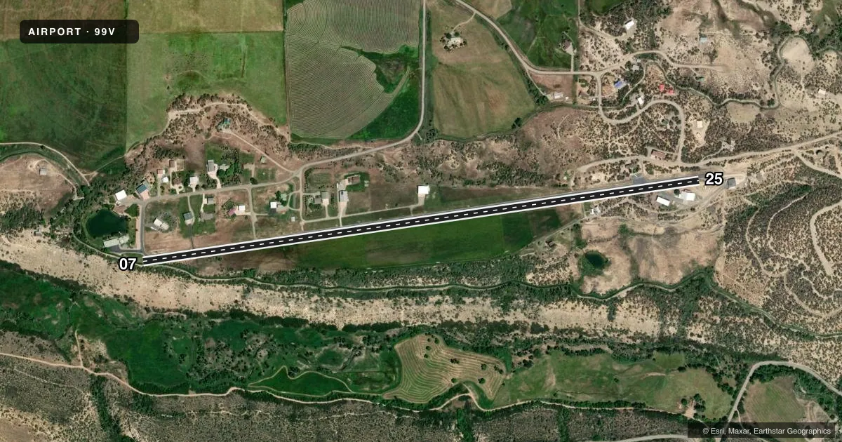
Runways & pattern
Full pagePattern entry · RWY 07
LEFT TRAFFICRunway end performance
| End | TORA | TODA | ASDA | LDA | VGSI | Approach lights | Obstruction |
|---|---|---|---|---|---|---|---|
| 07 | — | — | — | — | NSTD | — | 27', trees, 340' from thr, 90' R of cntrln, slope 4 |
| 25 | — | — | — | — | — | — | 19', hangar, 205' from thr, 65' R of cntrln, slope 0 |
Declared distances in feet. TORA = takeoff run available, TODA = takeoff distance, ASDA = accelerate-stop, LDA = landing distance.
Airport sketch
Runways drawn to scale from FAA survey coordinates, rendered over satellite imagery. Not for navigation.
Approaches & charts
Services on the field
Fuel grades, oxygen, maintenance, ramp storage and lighting — as declared to the FAA by the airport operator.
Fuel & services
- Fuel
- Not available
- Airframe repair
- Minor
- Power plant repair
- Minor
- Other services
- GLD,INSTR,TOW
Ramp & ground
- Transient storage
- Tie-down
- Hangar
- Landing fee
- No fee published
- Lighting schedule
- SEE RMK
- Wind indicator
- Lighted
- Segmented circle
- No
Fuel & FBOs
Cheapest 100LL and Jet A on the field and nearby. Always confirm with the FBO before taxi.
Airport notes
Surface conditions, obstructions, local procedures, lighting outages and other notes published with each FAA cycle.
General notes
- +45 FT TREE 100 FT L OF RY 07 EXTDD CNTRLN 414 FT FM RY END.
- RY 25 HAS +20 FT TREES 300 FT FM THLD 0B.
- RY 25 HAS 50 FT WATER TANKS 900 FT FM THLD ON EXTDD CNTRLN; +2 FT ELECTRIC BOX 150 FT FM THLD 30 FT R; +10 FT RD 100 FT FM THLD 0B.
- PEDESTRIANS, MOTOR VEHICLES, DEER AND WILDLIFE ON & INVOF ARPT.
- RY E HAS +20 FT TREES AT THLD 150 FT R OF CNTRLN; +10 FT TREES 150 FT FM THLD 0B.
- RY W HAS +35 FT BLDG 170 FT WEST OF THLD 30 FT L; +10 RD 100 FT FM THLD CNTRLN; +15 FT TREES 150 FT FM THLD 0B.
- UNLIMITED VEHICLE USE ON ARPT.
- (A70) 100LL FUEL AVBL FOR EMERG USE ONLY.
- -8 FT TO -20 FT TERRAIN OFF BOTH SIDES OF FIRST 674 FT OF RY 25 END.
- GLIDER OPERATIONS INVOF ARPT.
- RY 07, HAS 40 FT TREES AND -10 FT TO -20FT TERRAIN 20 FT RIGHT OF RY FIRST 150 FT.
- FOR CD CTC DENVER ARTCC AT 303-651-4257.
Lighting notes
- DUSK-0000
Runway surface & condition
- 07/25LND TO THE EAST; TKOF TO THE WEST WINDS PERMITTING.
- 07/25NSTD LIRL; RY 07/25 HAS LIRL ONLY ON NORTH SIDE ON RY FOR CENTER 1600 FT BEGINNING 1200 EAST OF RY 7 THLD. NO THLD LIGHTS. RY 07/25 3800 FT USBL FOR NIGHT OPNS.
- 07/25WEST 1300 FT ONLY 25 FT WIDE.
Approach & departure obstructions
- 25HAS 20 FT TREES 50 FT FROM THLD 50 FT L & R OF CNTRLN; +25 FT BUILDING 150 FT FM THLD 30 FT L OF CNTRLN.
- 07HAS 10 FT ROAD EXTENDING WEST FROM RY THRESHOLD.
- 07NSTD VASI, HAS 1 VASI BOX ON LEFT AND RIGHT SIDE OF RY. FOR LOCAL OPERATORS ONLY OR PPR CALL 970-921-7700.
Other notes
- MANAGEROR CALL ROB DUNCAN 970-921-3400
- E/WHAS 6 INCH DIAMETER IRRIGATION PIPES CROSSING RUNWAY WIDTH IN VARIOUS PLACES. CONSISTS OF +12 INCH ALFALFA VEGETATION DURING VARIOUS TIMES OF THE YEAR.
VFR map & nearby airports
VFR sectional. Tap any ICAO chip to open that airport.
Key facts · 99V
Answer card- ICAO
- 99V
- Name
- CRAWFORD
- Location
- CRAWFORD, COLORADO
- Elevation
- 6,470 ft MSL
- Traffic pattern altitude
- 7,270 ft MSL (800 AGL)
- Control tower
- Non-towered (use CTAF)
- Total runways
- 1
- Longest runway
- 07/25 · 4,900 ft
- Published ILS approaches
- 0
- Published frequencies
- 2
- Magnetic variation
- 13°
- Current flight rules
- VFR
- Current wind
- 140° at 10 kt
- Favored runway now
- RWY 07
Crawford Airport (99V) sits in Crawford, Colorado. Field elevation is 6,470 ft MSL. The airport has one runway. Runway 07/25 is 4,900 ft long with an asphalt surface. There is no control tower. CTAF and UNICOM are both 122.8.
Pattern altitude is 800 ft AGL. That puts the traffic pattern at 7,270 ft MSL. No ILS approaches are published here. The field uses lighting from dusk to 0000. If you are planning a night arrival, verify the current lighting status before you go.
There is no on-field FBO listed. 100LL fuel is available for emergency use only. For current fuel or service options, contact the airport operator or the field directly by phone before arrival. The published remarks also call out wildlife on and near the airport. Deer, pedestrians and motor vehicles have all been noted in the movement area vicinity. Glider operations are also in the area.
Runway 25 has several close-in obstacles near the threshold. Runway 07 has trees and nearby terrain close to the surface in the first 150 feet. The airport also has irrigation pipes crossing runway E/W in various places. This is a field where a careful taxi and a close look at the current Chart Supplement make sense before you launch or land.