METAR & TAF KAJZ
Current METAR
Observed 00:35Z
KAJZ 270035Z AUTO 17008G22KT 10SM VCTS BKN120 23/16 A3019 RMK AO2 LTG DSNT ALQS T02340164
- Wind
- 170° @ 8G22 kt
- Visibility
- 10 SM
- Temp / Dew
- 23°C / 16°C
- Altimeter
- 30.19 inHg
- Clouds
- BKN
- Density alt
- 7,065 ft
- Ceiling
- 12,000 ft AGL
- Rules
- VFR
Airport info & contacts
Manager on record, flight service, ARTCC, attendance schedule and pattern altitude — published by the FAA and refreshed every 28 days.
Location
- From city
- 3 NM N
- VFR sectional
- DENVER
- Pattern altitude
- 1,007 ft AGL · 6,200 ft MSL
- ARTCC
- ZDV · DENVER
- NOTAM facility
- DEN (NOTAM-D)
Airport manager
- Name
- MARK HUSMANN
- Phone
- 970-874-5181
- Address
- 870 - 1575 ROAD, DELTA CO 81416
Flight service · Hours
- FSS DEN
- DENVER1-800-WX-BRIEF
- Attendance
- MON-FRI · 0800-1700
Frequencies
Tap any row to copy the frequency to your clipboard.
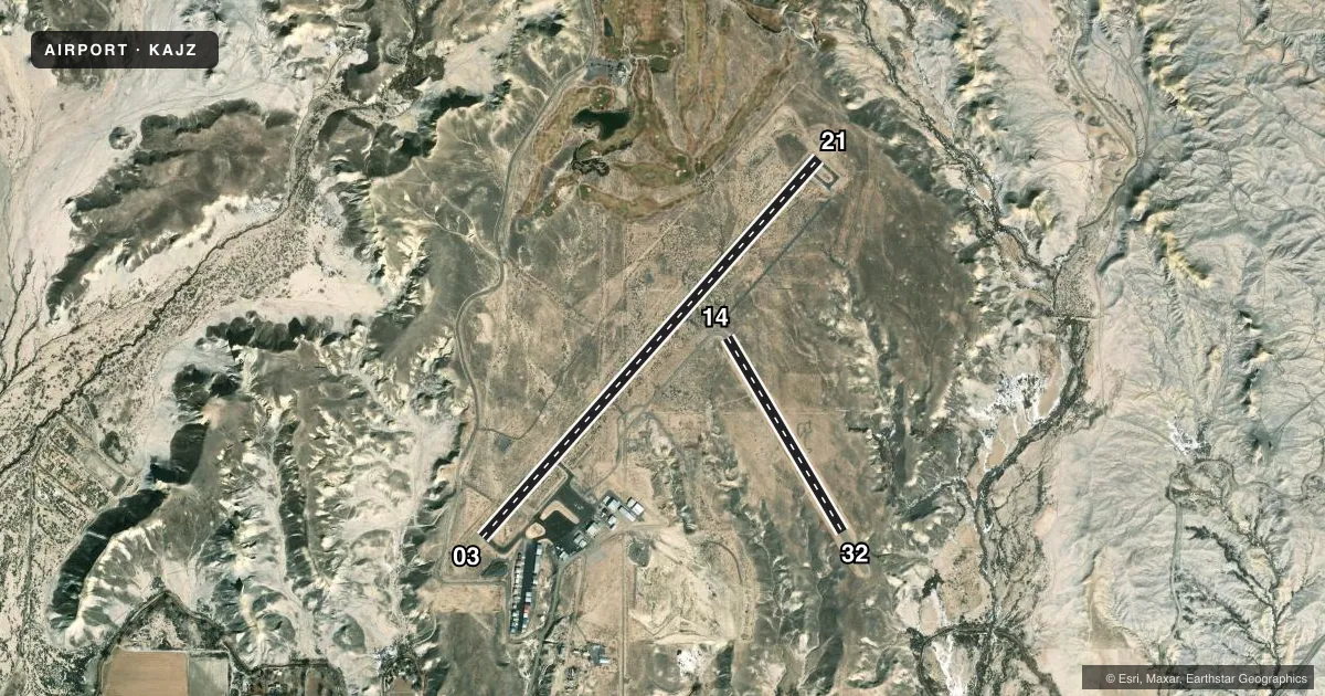
Runways & pattern
Full pagePattern entry · RWY 14
LEFT TRAFFIC| Runway | Heading (°M) | Length | Surface | Traffic |
|---|---|---|---|---|
| 03/21 | 32° / 212° | 5,598 ft | ASPH | 03 R |
| 14/32Favored | 139° / 319° | 2,494 ft | DIRT | Standard L |
Runway end performance
| End | TORA | TODA | ASDA | LDA | VGSI | Approach lights | Obstruction |
|---|---|---|---|---|---|---|---|
| 03 | — | — | — | — | PAPI 2-box left(3°) | — | — |
| 21 | — | — | — | — | PAPI 2-box left(3°) | — | — |
Declared distances in feet. TORA = takeoff run available, TODA = takeoff distance, ASDA = accelerate-stop, LDA = landing distance.
Airport sketch
Runways drawn to scale from FAA survey coordinates, rendered over satellite imagery. Not for navigation.
Approaches & charts
Services on the field
Fuel grades, oxygen, maintenance, ramp storage and lighting — as declared to the FAA by the airport operator.
Fuel & services
- Fuel
- 100LLA
- Oxygen (bottled)
- High pressure
- Oxygen (bulk)
- Not available
- Airframe repair
- Major
- Power plant repair
- Minor
- Other services
- AMB,GLD,INSTR,RNTL,TOW
Ramp & ground
- Transient storage
- Tie-down
- Hangar
- Landing fee
- No fee published
- Customs
- Not available
- Lighting schedule
- SEE RMK
- Beacon schedule
- SS-SR
- Beacon
- White / Green (civil land)(WG)
- Wind indicator
- Lighted
- Segmented circle
- Yes
Fuel & FBOs
Cheapest 100LL and Jet A on the field and nearby. Always confirm with the FBO before taxi.
Airport notes
Surface conditions, obstructions, local procedures, lighting outages and other notes published with each FAA cycle.
General notes
- ANTELOPE ON AND INVOF ARPT.
- RY 21 HAS TURN AROUND TAXI HAS BLUE/WHITE REFLECTORS.
- RY 03/21 SLOPES UP TO THE NE.
- RY 03/21 HAS 4 FT BUSHES 15-20 FT FROM RY EDGE ON BOTH SIDES IN VARIOUS PLACES.
- 24 HOUR SELF SERVE FUEL AVBL.
- RY 3 HAS +4 FT FENCE 580 FT FM THLD OB.
- POWER LINES 2640' NW RY 03/21, +52 FT AGL.
- FOR CD CTC DENVER ARTCC AT 303-651-4257.
Lighting notes
- ACTVT REIL RWY 03 & 21; MIRL RWY 03/21 - CTAF. PAPI RWY 03 & 21 ON CONSLY.
Approach & departure obstructions
- 034 FT FENCE 580 FT FM THLD ON EXTDD CNTRLN.
Other notes
- ESTABLISHED PRIOR TO 1959.
- 1AFT HRS EMERG FONE, SHERIFF DEPT 970-874-2000/AFT HRS SVC 970-209-0883.
VFR map & nearby airports
VFR sectional. Tap any ICAO chip to open that airport.
Key facts · KAJZ
Answer card- ICAO
- KAJZ
- Name
- BLAKE FLD
- Location
- DELTA, COLORADO
- Elevation
- 5,193.1 ft MSL
- Traffic pattern altitude
- 6,200.1 ft MSL (1,007 AGL)
- Control tower
- Non-towered (use CTAF)
- Total runways
- 2
- Longest runway
- 03/21 · 5,598 ft
- Published ILS approaches
- 0
- Published frequencies
- 2
- Magnetic variation
- 10°
- Current flight rules
- VFR
- Current wind
- 170° at 8 kt
- Favored runway now
- RWY 14
Blake Fld (KAJZ) sits in Delta, Colorado. Field elevation is 5,193.1 ft MSL. The airport has 2 runways. The longest is runway 03/21 at 5,598 ft. There is no control tower. CTAF and UNICOM are both 122.8. No ILS approaches are published here.
Pattern altitude is 6,200.1 ft MSL, which is 1,007 ft AGL. Runway 03/21 is the main paved runway. It slopes up to the northeast. Runway 03 and 21 have REILs. Medium intensity runway lights on 03/21 are CTAF controlled. PAPI is on runway 03 and 21. Runway 14/32 is a 2,494 ft dirt strip.
Smiling Aviation is on the field. It carries 100LL and Jet A. Twenty-four hour self-serve fuel is available. Published remarks also note antelope on and near the airport. Runway 03 has a fence over 4 ft tall about 580 ft from the threshold. Power lines sit northwest of runway 03/21. This is a high-elevation field, so density altitude will matter. Plan performance carefully. Check the current FAA Chart Supplement for any current operational notes before departure.