METAR & TAF KLXV
Current METAR
Observed 06:04Z
KLXV 270604Z AUTO 00000KT 7SM -RA BKN004 BKN040 OVC060 12/11 A3068 RMK AO2 P0001 T01170111
- Wind
- 000° @ 0 kt
- Visibility
- 7 SM
- Temp / Dew
- 12°C / 11°C
- Altimeter
- 30.68 inHg
- Clouds
- OVC
- Density alt
- 11,015 ft
- Ceiling
- 400 ft AGL
- Rules
- LIFR
Airport info & contacts
Manager on record, flight service, ARTCC, attendance schedule and pattern altitude — published by the FAA and refreshed every 28 days.
Location
- From city
- 2 NM SW
- VFR sectional
- DENVER
- ARTCC
- ZDV · DENVER
- NOTAM facility
- LXV (NOTAM-D)
Airport manager
- Name
- JOSH ADAMSON
- Phone
- 719-486-0307
- Address
- 915 CR 23, BOX 952, LEADVILLE CO 80461
Flight service · Hours
- FSS DEN
- DENVER1-800-WX-BRIEF
- Attendance
- MAY-SEP · 0730-1630
- OCT-APR · 0800-1630
Frequencies
Tap any row to copy the frequency to your clipboard.
Runways & pattern
Full pagePattern entry · RWY 16
RIGHT TRAFFICRunway end performance
| End | TORA | TODA | ASDA | LDA | VGSI | Approach lights | Obstruction |
|---|---|---|---|---|---|---|---|
| 16 | — | — | — | — | PAPI 2-box left(3°) | — | — |
| 34 | — | — | — | — | PAPI 2-box left(3°) | — | — |
Declared distances in feet. TORA = takeoff run available, TODA = takeoff distance, ASDA = accelerate-stop, LDA = landing distance.
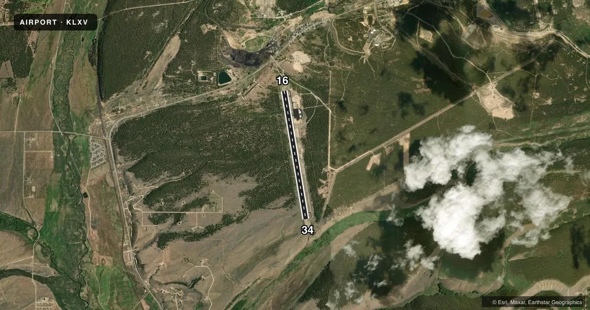
Airport sketch
Runways drawn to scale from FAA survey coordinates, rendered over satellite imagery. Not for navigation.
Approaches & charts
Services on the field
Fuel grades, oxygen, maintenance, ramp storage and lighting — as declared to the FAA by the airport operator.
Fuel & services
- Fuel
- 100LLA
- Oxygen (bottled)
- Not available
- Oxygen (bulk)
- Not available
- Other services
- CHTR
Ramp & ground
- Transient storage
- Tie-down
- Hangar
- Landing fee
- No fee published
- Customs
- Not available
- Lighting schedule
- SEE RMK
- Beacon schedule
- SS-SR
- Beacon
- White / Green (civil land)(WG)
- Wind indicator
- Lighted
- Segmented circle
- Yes
Fuel & FBOs
Cheapest 100LL and Jet A on the field and nearby. Always confirm with the FBO before taxi.
Airport notes
Surface conditions, obstructions, local procedures, lighting outages and other notes published with each FAA cycle.
General notes
- OBSTRN LGTS ON BCN TWR.
- ALL TWYS & NEW RAMP AREA MKD WITH BLUE & WHITE REFLECTORS.
- TWY C AND OLD RAMP HAVE POTHOLES & LOOSE AGGREGATE.
- RY H1 HAS 20-30 FT TREES 130 FT EAST OF PAD.
- ALL PAVEMENT EDGES HAVE SOFT SHOULDERS.
- RY 34 HA +50 FT POWER LINES 750 FT RIGHT OF THRESHOLD.
- FOR CD CTC DENVER ARTCC AT 303-651-4257.
Lighting notes
- ACTVT PAPI RWY 16 & 34; MIRL RWY 16/34 - CTAF.
Other notes
- 1PPR FOR SVC AFT HRS CALL 719-427-0026.
- H1RY H1 HAS 6-8 INCH LIP ALL AROUND EDGES; CONCRETE HAS LONGITUDINAL & CORNER CRACKING.
VFR map & nearby airports
VFR sectional. Tap any ICAO chip to open that airport.
Key facts · KLXV
Answer card- ICAO
- KLXV
- Name
- LAKE COUNTY
- Location
- LEADVILLE, COLORADO
- Elevation
- 9,933.5 ft MSL
- Traffic pattern altitude
- 10,933.5 ft MSL (1,000 AGL)
- Control tower
- Non-towered (use CTAF)
- Total runways
- 1
- Longest runway
- 16/34 · 6,400 ft
- Published ILS approaches
- 0
- Published frequencies
- 2
- Magnetic variation
- 9°
- Current flight rules
- LIFR
- Current wind
- 000° at 0 kt
- Favored runway now
- –
Lake County Airport sits in Leadville, Colorado at 9,933.5 ft MSL. It has one runway, 16/34, which is 6,400 ft long and paved with asphalt. There is no control tower. CTAF and UNICOM are both 122.8. No ILS approaches are published here, so plan with that in mind before you arrive.
The published pattern altitude is not listed. Use the standard 1,000 ft AGL for light piston aircraft unless the current Chart Supplement gives you something different. The field is high enough that density altitude will matter on warm days. Expect reduced climb performance and longer takeoff rolls.
Lake County Airport is on the field. It carries 100LL and Jet A. Call the FBO directly at (719) 486-0307 for current availability. The published remarks also note that runway 16 and 34 have active PAPI, with medium intensity runway lights controlled on CTAF. For after-hours service, prior permission is required.
There are a few surface and obstacle items to brief before landing. Taxiway C and the old ramp have potholes and loose aggregate. Runway 34 has 50 ft power lines 750 ft right of the threshold. H1 has trees near the pad, plus a lip and cracking on the concrete. This is a high-altitude field in mountain country, so give yourself extra margin and verify current details with the airport operator or the current FAA Chart Supplement.