METAR & TAF KGWS
KGWS does not publish a METAR.
Showing the nearest reporting station: KRIL (RIFLE GARFIELD COUNTY) · 19.4 NM away. Conditions at KGWS may differ.
METAR · KRIL
Observed 02:53Z
KRIL 270253Z AUTO 08014KT 10SM CLR 28/10 A3016 RMK AO2 SLP129 T02830100 53005
- Wind
- 080° @ 14 kt
- Visibility
- 10 SM
- Temp / Dew
- 28°C / 10°C
- Altimeter
- 30.16 inHg
- Clouds
- CLR
- Density alt
- 8,598 ft
- Ceiling
- Unlimited
- Rules
- VFR
Airport info & contacts
Manager on record, flight service, ARTCC, attendance schedule and pattern altitude — published by the FAA and refreshed every 28 days.
Location
- From city
- 3 NM S
- VFR sectional
- DENVER
- ARTCC
- ZDV · DENVER
- NOTAM facility
- DEN (NOTAM-D)
Airport manager
- Name
- AMY HELM
- Phone
- 970-987-5916
- Address
- 100 WULFSOHN ROAD, GLENWOOD SPRINGS CO 81601
Flight service · Hours
- FSS DEN
- DENVER1-800-WX-BRIEF
- Attendance
- MON-FRI · 0800-1700
Frequencies
Tap any row to copy the frequency to your clipboard.
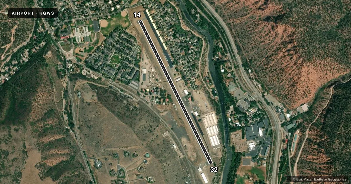
Runways & pattern
Full pagePattern entry · RWY 14
LEFT TRAFFICRunway end performance
| End | TORA | TODA | ASDA | LDA | VGSI | Approach lights | Obstruction |
|---|---|---|---|---|---|---|---|
| 14 | — | — | — | — | — | — | 71', trees, 560' from thr, 36' R of cntrln, slope 5 |
| 32 | — | — | — | — | PAPI 2-box left(4°) | — | 14', road, 209' from thr, 16' R of cntrln, slope 0 |
Declared distances in feet. TORA = takeoff run available, TODA = takeoff distance, ASDA = accelerate-stop, LDA = landing distance.
Airport sketch
Runways drawn to scale from FAA survey coordinates, rendered over satellite imagery. Not for navigation.
Approaches & charts
Services on the field
Fuel grades, oxygen, maintenance, ramp storage and lighting — as declared to the FAA by the airport operator.
Fuel & services
- Fuel
- 100LLA
- Oxygen (bottled)
- HIGH/LOW
- Oxygen (bulk)
- Not available
- Airframe repair
- Major
- Power plant repair
- Major
- Other services
- AFRT,AMB,CHTR,INSTR
Ramp & ground
- Transient storage
- Tie-down
- Landing fee
- No fee published
- Customs
- Not available
- Wind indicator
- Yes
- Segmented circle
- No
Fuel & FBOs
Cheapest 100LL and Jet A on the field and nearby. Always confirm with the FBO before taxi.
Airport notes
Surface conditions, obstructions, local procedures, lighting outages and other notes published with each FAA cycle.
General notes
- +2000' MTNS SURROUND ARPT.
- GUSTY WINDS FREQUENTLY INVOF ARPT.
- NOISE ABATEMENT: WHEN WIND & WEA PERMIT USE RWY 32 FOR ARVL AND RWY 14 FOR DEP.
- RY 32 HAS 20 FT HGRS & +30 FT ANTENNA 200 FT L OF CNTRLN AT THLD.
- NO TOUCH AND GO LANDINGS.
- WILDLIFE ON & INVOF ARPT.
- NUMEROUS +25 FT BLDGS; TREES; EQUIPMENT; TIEDOWNS APRXLY 150 FT FM CNTRLN - BOTH SIDES OF RY FULL LENGTH.
- ARPT MGR ON CALL: 970-445-0965. FBO PH: 970-945-3073.
- PARAGLIDING OPNS VICINITY ONE TO TWO MILES NORTHWEST OF ARPT UP TO 18,000 FT MSL.
- FOR CD IF UNA TO CTC ON FSS FREQ, CTC DENVER ARTCC AT 303-651-4257.
Fuel notes
- 100LLFUEL AVAILABLE 24 HRS VIA SELF-SERVE CREDIT CARD PUMP.
Approach & departure obstructions
- 14HAS +5 FT BUSH 50 FT L OF CNTRLN 150 FT FM RY END; +5 FT BRUSH 135 FT FM THLD 20 FT R OF CNTRLN.
- 32100 FT DROPOFF 200 FT FM THLD.
- 14PUB RD 209 FT FM RWY END, 14 FT ABV RWY & 14 FT FM LT OF CTLN.
Other notes
- ESTABD PRIOR TO 1959.
- AUTOMATED UNICOM; 3 CLICKS ADZY.
VFR map & nearby airports
VFR sectional. Tap any ICAO chip to open that airport.
Key facts · KGWS
Answer card- ICAO
- KGWS
- Name
- KGWS SUMERS AIRPARK
- Location
- GLENWOOD SPRINGS, COLORADO
- Elevation
- 5,916 ft MSL
- Traffic pattern altitude
- 6,916 ft MSL (1,000 AGL)
- Control tower
- Non-towered (use CTAF)
- Total runways
- 1
- Longest runway
- 14/32 · 3,305 ft
- Published ILS approaches
- 0
- Published frequencies
- 2
- Magnetic variation
- 13°
- Current flight rules
- VFR
- Current wind
- 080° at 14 kt
- Favored runway now
- RWY 14
KGWS Sumers Airpark sits in Glenwood Springs, Colorado. The field elevation is 5,916 ft MSL. It has one runway. Runway 14/32 is 3,305 ft long and asphalt. There is no control tower. CTAF and UNICOM are both 123.0. No ILS approaches are published.
Pattern altitude is not published. Use the standard 1,000 ft AGL pattern unless local guidance says otherwise. That puts the light-piston pattern at 6,916 ft MSL. The airport sits in mountain country. Mountains over 2,000 ft surround the field. That means density altitude and climb performance matter here. This is especially true on warm days.
The on-field FBO is Glenwood Springs Municipal Airport. It carries AVGAS_100LL and JET_A_PRIST. The airport manager is on call at 970-445-0965. Automated UNICOM is available with three clicks advisory. Published remarks also call out wildlife on and near the airport. There are obstructions near both runway ends. That includes a dropoff near runway 32 and a bush near runway 14. Noise abatement asks pilots to use runway 32 for arrivals and runway 14 for departures when wind and weather allow. No touch-and-go landings are permitted. First-time visitors should brief the terrain, the runway environment and the published remarks before arrival.