METAR & TAF KEEO
Current METAR
Observed 05:53Z
KEEO 270553Z AUTO 00000KT 10SM CLR 22/11 A3028 RMK AO2 SLP138 T02170106 10306 20217 51015
- Wind
- 000° @ 0 kt
- Visibility
- 10 SM
- Temp / Dew
- 22°C / 11°C
- Altimeter
- 30.28 inHg
- Clouds
- CLR
- Density alt
- 8,349 ft
- Ceiling
- Unlimited
- Rules
- VFR
Airport info & contacts
Manager on record, flight service, ARTCC, attendance schedule and pattern altitude — published by the FAA and refreshed every 28 days.
Location
- From city
- 2 NM E
- VFR sectional
- CHEYENNE
- ARTCC
- ZDV · DENVER
- NOTAM facility
- EEO (NOTAM-D)
Airport manager
- Name
- LANNY COULTER
- Phone
- 970-878-5045
- Address
- BOX A, MEEKER CO 81641
Flight service · Hours
- FSS DEN
- DENVER1-800-WX-BRIEF
- Attendance
- ALL
Frequencies
Tap any row to copy the frequency to your clipboard.
Runways & pattern
Full pagePattern entry · RWY 03
RIGHT TRAFFICRunway end performance
| End | TORA | TODA | ASDA | LDA | VGSI | Approach lights | Obstruction |
|---|---|---|---|---|---|---|---|
| 03 | — | — | — | — | PAPI 2-box left(3°) | — | — |
| 21 | — | — | — | — | — | — | 113', hill, 3411' from thr, 0' R of cntrln, slope 28 |
Declared distances in feet. TORA = takeoff run available, TODA = takeoff distance, ASDA = accelerate-stop, LDA = landing distance.
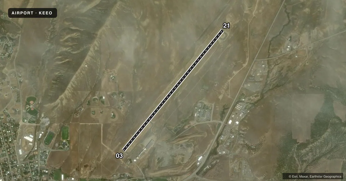
Airport sketch
Runways drawn to scale from FAA survey coordinates, rendered over satellite imagery. Not for navigation.
Approaches & charts
Services on the field
Fuel grades, oxygen, maintenance, ramp storage and lighting — as declared to the FAA by the airport operator.
Fuel & services
- Fuel
- 100LLA
- Oxygen (bottled)
- Not available
- Oxygen (bulk)
- HIGH/LOW
- Airframe repair
- Major
- Power plant repair
- Major
- Other services
- AFRT,AGRI,AMB,CARGO,CHTR,INSTR,SALES
Ramp & ground
- Transient storage
- Tie-down
- Hangar
- Landing fee
- No fee published
- Customs
- Not available
- Lighting schedule
- SEE RMK
- Beacon schedule
- SS-SR
- Beacon
- White / Green (civil land)(WG)
- Wind indicator
- Lighted
- Segmented circle
- Yes
Fuel & FBOs
Cheapest 100LL and Jet A on the field and nearby. Always confirm with the FBO before taxi.
Airport notes
Surface conditions, obstructions, local procedures, lighting outages and other notes published with each FAA cycle.
General notes
- MOUNTAINS SURROUND ARPT.
- DEER, ELK & WATERFOWL INVOF ARPT, WILDLIFE FENCE SURROUNDS ARPT.
- COLD TEMPERATURE AIRPORT. ALTITUDE CORRECTION REQUIRED AT OR BELOW -22C.
Lighting notes
- ACTVT MIRL RY 03/21; PAPI RY 03 AND REIL RY 03 & RY 21 - CTAF.
Approach & departure obstructions
- 03RY 3 PAPI DOES NOT PROVIDE OBSTRUCTION CLEARANCE BYD 2.5 NM FROM THLD.
VFR map & nearby airports
VFR sectional. Tap any ICAO chip to open that airport.
Key facts · KEEO
Answer card- ICAO
- KEEO
- Name
- MEEKER COULTER FLD
- Location
- MEEKER, COLORADO
- Elevation
- 6,415.4 ft MSL
- Traffic pattern altitude
- 7,415.4 ft MSL (1,000 AGL)
- Control tower
- Non-towered (use CTAF)
- Total runways
- 1
- Longest runway
- 03/21 · 6,503 ft
- Published ILS approaches
- 0
- Published frequencies
- 2
- Magnetic variation
- 9°
- Current flight rules
- VFR
- Current wind
- 000° at 0 kt
- Favored runway now
- –
Meeker Coulter Field sits in Meeker, Colorado. The field elevation is 6,415.4 ft MSL. It has one runway. Runway 03/21 is 6,503 ft of asphalt, which gives you the only paved option on the field. There is no control tower. CTAF and UNICOM are both 122.8.
No ILS approaches are published here. Pattern altitude is not published, so use the standard 1,000 ft AGL for light piston operations unless the current Chart Supplement says otherwise. Coulter Aviation is on the field. It carries 100LL and Jet A. Call (970) 878-5045 for current service details.
This is a mountain airport. Terrain surrounds the field. That matters for climb performance, approach planning and go-around margins. The published remarks also note a cold temperature correction requirement at or below minus 22 degrees Celsius. Wildlife is another factor here. Deer, elk and waterfowl are reported near the airport. A wildlife fence surrounds the field. You still want to stay alert on taxi, takeoff and landing. Runway 03 has a PAPI, though the published note says it does not provide obstruction clearance beyond 2.5 NM from the threshold. Use the current Chart Supplement for any additional local procedures before you go.