METAR & TAF KSBS
Current METAR
Observed 12:55Z
KSBS 271255Z AUTO 00000KT 10SM OVC110 17/11 A3029 RMK AO1 T01720105
- Wind
- 000° @ 0 kt
- Visibility
- 10 SM
- Temp / Dew
- 17°C / 11°C
- Altimeter
- 30.29 inHg
- Clouds
- OVC
- Density alt
- 8,315 ft
- Ceiling
- 11,000 ft AGL
- Rules
- VFR
Airport info & contacts
Manager on record, flight service, ARTCC, attendance schedule and pattern altitude — published by the FAA and refreshed every 28 days.
Location
- From city
- 3 NM NW
- VFR sectional
- CHEYENNE
- ARTCC
- ZDV · DENVER
- NOTAM facility
- SBS (NOTAM-D)
Airport manager
- Name
- JOSHUA SCHROEDER
- Phone
- 970-879-9042
- Address
- 3499 AIRPORT CIRCLE, STEAMBOAT SPRINGS CO 80477
Flight service · Hours
- FSS DEN
- DENVER1-800-WX-BRIEF
- Attendance
- MAY-OCT · 0700-1700
- NOV-APR · 0700-1700
Frequencies
Tap any row to copy the frequency to your clipboard.
Runways & pattern
Full pagePattern entry · RWY 14
RIGHT TRAFFICRunway end performance
| End | TORA | TODA | ASDA | LDA | VGSI | Approach lights | Obstruction |
|---|---|---|---|---|---|---|---|
| 14 | 4,452' | 4,452' | 3,852' | 3,852' | — | — | — |
| 32 | 4,452' | 4,452' | 4,452' | 3,852' | PAPI 2-box left(4°) | — | — |
Declared distances in feet. TORA = takeoff run available, TODA = takeoff distance, ASDA = accelerate-stop, LDA = landing distance.
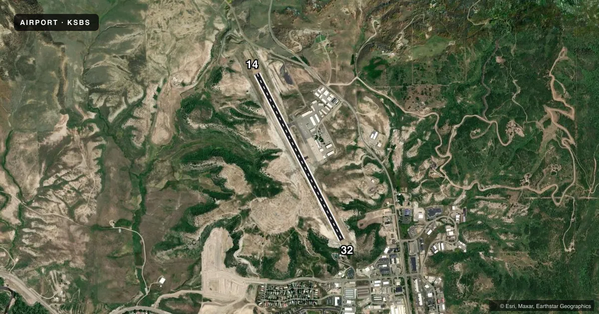
Airport sketch
Runways drawn to scale from FAA survey coordinates, rendered over satellite imagery. Not for navigation.
Approaches & charts
Services on the field
Fuel grades, oxygen, maintenance, ramp storage and lighting — as declared to the FAA by the airport operator.
Fuel & services
- Fuel
- 100LLA
- Oxygen (bottled)
- HIGH/LOW
- Oxygen (bulk)
- HIGH/LOW
- Airframe repair
- Minor
- Power plant repair
- Minor
- Other services
- AMB,CHTR,INSTR
Ramp & ground
- Transient storage
- Tie-down
- Hangar
- Landing fee
- Yes
- Customs
- Not available
- Lighting schedule
- SEE RMK
- Beacon schedule
- SS-SR
- Beacon
- White / Green (civil land)(WG)
- Wind indicator
- Lighted
- Segmented circle
- Yes
Fuel & FBOs
Cheapest 100LL and Jet A on the field and nearby. Always confirm with the FBO before taxi.
Airport notes
Surface conditions, obstructions, local procedures, lighting outages and other notes published with each FAA cycle.
General notes
- WILDLIFE ON & INVOF ARPT.
- COLD TEMPERATURE AIRPORT. ALTITUDE CORRECTION REQUIRED AT OR BELOW -25C.
- FOR CD IF UNA TO CTC ON FSS FREQ, CTC DENVER ARTCC AT 303-651-4257.
- SI NA TO AVOID TFC CONFLICTS.
Lighting notes
- ACTVT REIL RWY 32; PAPI RWY 32; HIRL RWY 14/32 - CTAF.
Approach & departure obstructions
- 32BRUSH 176 FT FM RWY END, 98 FT FM DSP THLD, 124 FT RT OF APCH, 7 FT ABV RWY END.
- 32PREFERRED RWY; 180 FT DROPOFF 2000 FT FM PAVEMENT END.
- 32PAPI BAFFLED; VIS LMTD TO 5.5 DEGS LEFT OF CNTRLN DUE TO HIGH TRRN.
Other notes
- NO LDG FEE FOR SNGL ENG PISTON ACFT.
- UNICOM AVBL 0700-1700.
VFR map & nearby airports
VFR sectional. Tap any ICAO chip to open that airport.
Key facts · KSBS
Answer card- ICAO
- KSBS
- Name
- STEAMBOAT SPRINGS/BOB ADAMS FLD
- Location
- STEAMBOAT SPRINGS, COLORADO
- Elevation
- 6,882.4 ft MSL
- Traffic pattern altitude
- 7,882.4 ft MSL (1,000 AGL)
- Control tower
- Non-towered (use CTAF)
- Total runways
- 1
- Longest runway
- 14/32 · 4,452 ft
- Published ILS approaches
- 0
- Published frequencies
- 2
- Magnetic variation
- 10°
- Current flight rules
- VFR
- Current wind
- 000° at 0 kt
- Favored runway now
- –
Steamboat Springs/Bob Adams Fld is in Steamboat Springs, Colorado. Field elevation is 6,882.4 ft MSL. The airport has one runway. Runway 14/32 is 4,452 ft long. There is no control tower. UNICOM is available from 0700 to 1700. CTAF is 122.8. No ILS approaches are published.
Pattern altitude is not published. Use the standard 1,000 ft AGL for light piston aircraft unless the current Chart Supplement says otherwise. That puts the pattern at 7,882.4 ft MSL. Steamboat Springs Airport is on the field. It carries 100LL and Jet A. Wildlife is present on and near the airport. Runway 32 is the preferred runway. The published remarks also note a dropoff beyond the runway end on 32. There is brush near the 32 threshold area. The airport is a cold temperature field. Altitude correction is required at or below minus 25 degrees Celsius.
This is a high-elevation mountain airport. Expect performance to matter. Density altitude can climb fast in warm weather. Terrain and obstacle awareness matter on both ends of the runway. Runway 32 has runway end identifier lights, a PAPI and high intensity runway lighting. Special instrument not authorized is published, so plan on current procedures and local traffic flow. Check the current FAA Chart Supplement for any changes before you go.