METAR & TAF KCAG
Current METAR
Observed 12:53Z
KCAG 271253Z AUTO 00000KT 10SM BKN120 16/12 A3024 RMK AO2 SLP157 T01560117
- Wind
- 000° @ 0 kt
- Visibility
- 10 SM
- Temp / Dew
- 16°C / 12°C
- Altimeter
- 30.24 inHg
- Clouds
- BKN
- Density alt
- 7,408 ft
- Ceiling
- 12,000 ft AGL
- Rules
- VFR
Airport info & contacts
Manager on record, flight service, ARTCC, attendance schedule and pattern altitude — published by the FAA and refreshed every 28 days.
Location
- From city
- 2 NM SE
- VFR sectional
- CHEYENNE
- ARTCC
- ZDV · DENVER
- NOTAM facility
- CAG (NOTAM-D)
Airport manager
- Name
- CANDACE MILLER
- Phone
- 970-824-9148
- Address
- 221 W VICTORY WAY, CRAIG CO 81625
Flight service · Hours
- FSS DEN
- DENVER1-800-WX-BRIEF
- Attendance
- MON-FRI · 0800-1700
- SAT-SUN · IRREG
Frequencies
Tap any row to copy the frequency to your clipboard.
Runways & pattern
Full pagePattern entry · RWY 07
LEFT TRAFFICRunway end performance
| End | TORA | TODA | ASDA | LDA | VGSI | Approach lights | Obstruction |
|---|---|---|---|---|---|---|---|
| 07 | — | — | — | — | — | — | 12', tree, 345' from thr, 6' R of cntrln, slope 12 |
| 25 | — | — | — | — | PAPI 4-box left(3°) | — | 32', tree, 457' from thr, 199' R of cntrln, slope 8 |
Declared distances in feet. TORA = takeoff run available, TODA = takeoff distance, ASDA = accelerate-stop, LDA = landing distance.
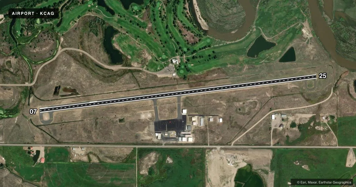
Airport sketch
Runways drawn to scale from FAA survey coordinates, rendered over satellite imagery. Not for navigation.
Approaches & charts
Services on the field
Fuel grades, oxygen, maintenance, ramp storage and lighting — as declared to the FAA by the airport operator.
Fuel & services
- Fuel
- 100LLA
- Oxygen (bottled)
- Not available
- Oxygen (bulk)
- Not available
- Other services
- AGRI
Ramp & ground
- Transient storage
- Tie-down
- Landing fee
- No fee published
- Customs
- Not available
- Lighting schedule
- SEE RMK
- Beacon schedule
- SS-SR
- Beacon
- White / Green (civil land)(WG)
- Wind indicator
- Lighted
- Segmented circle
- Yes
Fuel & FBOs
Cheapest 100LL and Jet A on the field and nearby. Always confirm with the FBO before taxi.
Airport notes
Surface conditions, obstructions, local procedures, lighting outages and other notes published with each FAA cycle.
General notes
- RY 25 HAS +10 FT ROAD 340 FT FM THLD OB, +41 FT TREES 1185 FT FM THLD 50 LEFT OF CNTRLN, +75 FT TREES 4000 FT FM THLD.
- WILDLIFE ON AND INVOF ARPT.
- COLD TEMPERATURE AIRPORT. ALTITUDE CORRECTION REQUIRED AT OR BELOW -27C.
- FOR CD CTC DENVER ARTCC AT 303-651-4257.
Lighting notes
- ACTVT PAPI RWY 25; REIL RWY 07 & 25; MIRL RWY 07/25 - CTAF.
Other notes
- OWNERCOUNTY CONTACT JERRY HOBERG AT 970-824-9148.
VFR map & nearby airports
VFR sectional. Tap any ICAO chip to open that airport.
Key facts · KCAG
Answer card- ICAO
- KCAG
- Name
- CRAIG-MOFFAT
- Location
- CRAIG, COLORADO
- Elevation
- 6,197.5 ft MSL
- Traffic pattern altitude
- 7,197.5 ft MSL (1,000 AGL)
- Control tower
- Non-towered (use CTAF)
- Total runways
- 1
- Longest runway
- 07/25 · 5,606 ft
- Published ILS approaches
- 0
- Published frequencies
- 2
- Magnetic variation
- 9°
- Current flight rules
- VFR
- Current wind
- 000° at 0 kt
- Favored runway now
- –
Craig-Moffat Airport sits in Craig, Colorado. The field elevation is 6,197.5 ft MSL. It has one runway, 07/25, which is 5,606 ft long. There is no control tower. CTAF and UNICOM are both 122.8. No ILS approaches are published.
The pattern altitude is not published. Use the standard 1,000 ft AGL for light piston aircraft unless the current Chart Supplement says otherwise. Mountain Air Spray is on the field. It carries 100LL and Jet A. Call them at (970) 824-6335 for current fuel and service details.
This is a high-elevation airport, so performance planning matters. Density altitude can be a factor even when the weather looks mild. Runway 25 has published obstructions near the approach path. There is a road close to the threshold, plus trees farther out and left of centerline. Lighting is pilot controlled through CTAF. PAPI is on runway 25. REIL and MIRL are on runways 07 and 25. The airport is also listed as a cold temperature airport. Altitude correction is required at or below minus 27 degrees Celsius. Wildlife has also been reported on and near the airport. Check the current FAA Chart Supplement before you go.