METAR & TAF KHDN
Current METAR
Observed 12:56Z
KHDN 271256Z AUTO 11007KT 10SM OVC110 18/10 A3028 RMK AO2 SLP158 T01830100
- Wind
- 110° @ 7 kt
- Visibility
- 10 SM
- Temp / Dew
- 18°C / 10°C
- Altimeter
- 30.28 inHg
- Clouds
- OVC
- Density alt
- 8,105 ft
- Ceiling
- 11,000 ft AGL
- Rules
- VFR
Airport info & contacts
Manager on record, flight service, ARTCC, attendance schedule and pattern altitude — published by the FAA and refreshed every 28 days.
Location
- From city
- 2 NM SE
- VFR sectional
- CHEYENNE
- ARTCC
- ZDV · DENVER
- NOTAM facility
- HDN (NOTAM-D)
Airport manager
- Name
- TINNEAL GERBER
- Phone
- 970-276-5021
- Address
- 11005 RCR 51A, PO BOX 1060, HAYDEN CO 81639
Flight service · Hours
- FSS DEN
- DENVER1-800-WX-BRIEF
- Attendance
- 0600-2100
Frequencies
Tap any row to copy the frequency to your clipboard.
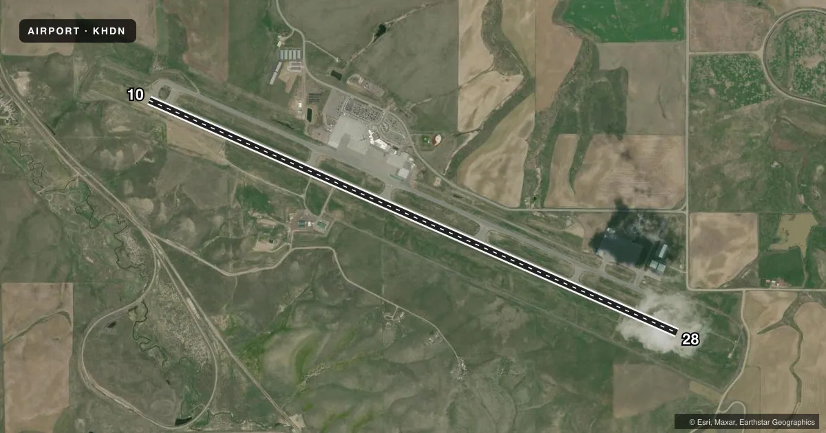
Runways & pattern
Full pagePattern entry · RWY 10
RIGHT TRAFFICRunway end performance
| End | TORA | TODA | ASDA | LDA | VGSI | Approach lights | Obstruction |
|---|---|---|---|---|---|---|---|
| 10 | 10,000' | 10,000' | 10,000' | 9,490' | PAPI 4-box left(3°) | MALSF | — |
| 28 | 10,000' | 10,000' | 10,000' | 10,000' | PAPI 4-box left(3.5°) | — | 110', pline, 3850' from thr, 0' R of cntrln, slope 34 |
Declared distances in feet. TORA = takeoff run available, TODA = takeoff distance, ASDA = accelerate-stop, LDA = landing distance.
Airport sketch
Runways drawn to scale from FAA survey coordinates, rendered over satellite imagery. Not for navigation.
Approaches & charts
ILS · 1
Services on the field
Fuel grades, oxygen, maintenance, ramp storage and lighting — as declared to the FAA by the airport operator.
Fuel & services
- Fuel
- 100LLA
- Oxygen (bottled)
- HIGH/LOW
- Airframe repair
- Not available
- Power plant repair
- Not available
- Other services
- AFRT,AMB
Ramp & ground
- Transient storage
- Tie-down
- Hangar
- Landing fee
- Yes
- Customs
- Not available
- Lighting schedule
- SEE RMK
- Beacon schedule
- SS-SR
- Beacon
- White / Green (civil land)(WG)
- Wind indicator
- Lighted
- Segmented circle
- Yes
Fuel & FBOs
Cheapest 100LL and Jet A on the field and nearby. Always confirm with the FBO before taxi.
Airport notes
Surface conditions, obstructions, local procedures, lighting outages and other notes published with each FAA cycle.
General notes
- REQ ALL ACFT DEPG RWY 28 MAKE RGT OR LEFT TURNOUT AS SOON AS SAFETY PERMITS AFTER TAKEOFF TO AVOID TOWN OF HAYDEN & COMPLY WITH NOISE ABATEMENT PROCS.
- LARGE FLOCKS OF SANDHILL CRANES AROUND ARPT IN SPRING AND FALL.
- ALL ACFT REPORT 10 MINUTES PRIOR TO TKOF/LNDG ON 123.0 - MONITOR FREQ 24 HRS, PAEW ON RWY.
- POSSIBLE SEVERE WINTER CONDITIONS FROM OCT-APR. CHECK NOTAMS FOR ARPT CONDITIONS. NO ARPT INFORMATION NOR SNOW REMOVAL GUARANTEED DURING HOURS OF NONATTENDANCE.
- RWY 28 PAPI DOES NOT PROVIDE OBST CLEARANCE BEYOND 4.0 NM FROM THRESHOLD.
- NO ARFF INDEX 2100-0600 UNLESS EXTN APVD BY ARPT NLT 2300.
- ARFF INDEX B APR 16-DEC 14 0600-2100. ARFF INDEX C DEC 15-APR 15 0600-2100.
Lighting notes
- ACTVT MALSF RWY 10; REIL RWY 28; PAPI RWY 10; HIRL RWY 10/28 - CTAF.
Runway surface & condition
- 10/28PCR VALUE: 600/F/D/X/T
Approach & departure obstructions
- 10OBSTRUCTION CLNC SLOPE 50:1 TO DSPLCD THLD.
Other notes
- CLSD TO UNSKED ACR OPNS WITH MORE THAN 30 PSGR SEATS EXCP PPR; CALL UNICOM 970-819-1333.
- LANDING FEE FOR ACFT 12,500 LBS & OVER.
- BTN 0600 - 2000 CTC UNICOM PRIOR TO ALL TKFS AND LNDGS FOR PAEW ADVISORIES.
VFR map & nearby airports
VFR sectional. Tap any ICAO chip to open that airport.
Key facts · KHDN
Answer card- ICAO
- KHDN
- Name
- YAMPA VALLEY
- Location
- HAYDEN, COLORADO
- Elevation
- 6,606.3 ft MSL
- Traffic pattern altitude
- 7,606.3 ft MSL (1,000 AGL)
- Control tower
- Non-towered (use CTAF)
- Total runways
- 1
- Longest runway
- 10/28 · 10,000 ft
- Published ILS approaches
- 1
- Published frequencies
- 2
- Magnetic variation
- 10°
- Current flight rules
- VFR
- Current wind
- 110° at 7 kt
- Favored runway now
- RWY 10
Yampa Valley Airport is in Hayden, Colorado. The field elevation is 6,606.3 ft MSL. It has one runway. Runway 10/28 is 10,000 ft long, so there is plenty of pavement for most general aviation traffic. The airport is not towered. CTAF and UNICOM are both 123.0.
The published ILS is on runway 10. Runway 10 also has a PAPI. Runway 10 has MALSR lighting. Runway 28 has runway end identifier lights. Pattern altitude is not published, so use the standard 1,000 ft AGL for light piston operations unless the current Chart Supplement or airport operator says otherwise. That puts the pattern at about 7,606.3 ft MSL.
Atlantic Aviation is on the field. It carries 100LL and Jet A. Call them at (970) 276-3743 for current ramp and service details. The remarks also call for UNICOM contact before all takeoffs and landings between 0600 and 2000 for PAEW advisories. Runway 28 departures need an early right or left turn as soon as safety permits to avoid Hayden and follow the noise abatement guidance. This is a high-elevation airport, so performance planning matters. Winter conditions can be severe from October through April. Check NOTAMs and current field status before you go. Large flocks of sandhill cranes are also a seasonal factor.