METAR & TAF 33V
Current METAR
Observed 15:15Z
K33V 271515Z AUTO 00000KT 10SM OVC090 16/11 A3044 RMK AO1
- Wind
- 000° @ 0 kt
- Visibility
- 10 SM
- Temp / Dew
- 16°C / 11°C
- Altimeter
- 30.44 inHg
- Clouds
- OVC
- Density alt
- 9,586 ft
- Ceiling
- 9,000 ft AGL
- Rules
- VFR
Airport info & contacts
Manager on record, flight service, ARTCC, attendance schedule and pattern altitude — published by the FAA and refreshed every 28 days.
Location
- From city
- 1 NM NE
- VFR sectional
- CHEYENNE
- ARTCC
- ZDV · DENVER
- NOTAM facility
- DEN (NOTAM-D)
Airport manager
- Name
- SAMANTHA MARTIN
- Phone
- 970-723-4660
- Address
- P. O. BOX 1019, WALDEN CO 80480
Flight service · Hours
- FSS DEN
- DENVER1-800-WX-BRIEF
- Attendance
- ON CALL
Frequencies
Tap any row to copy the frequency to your clipboard.
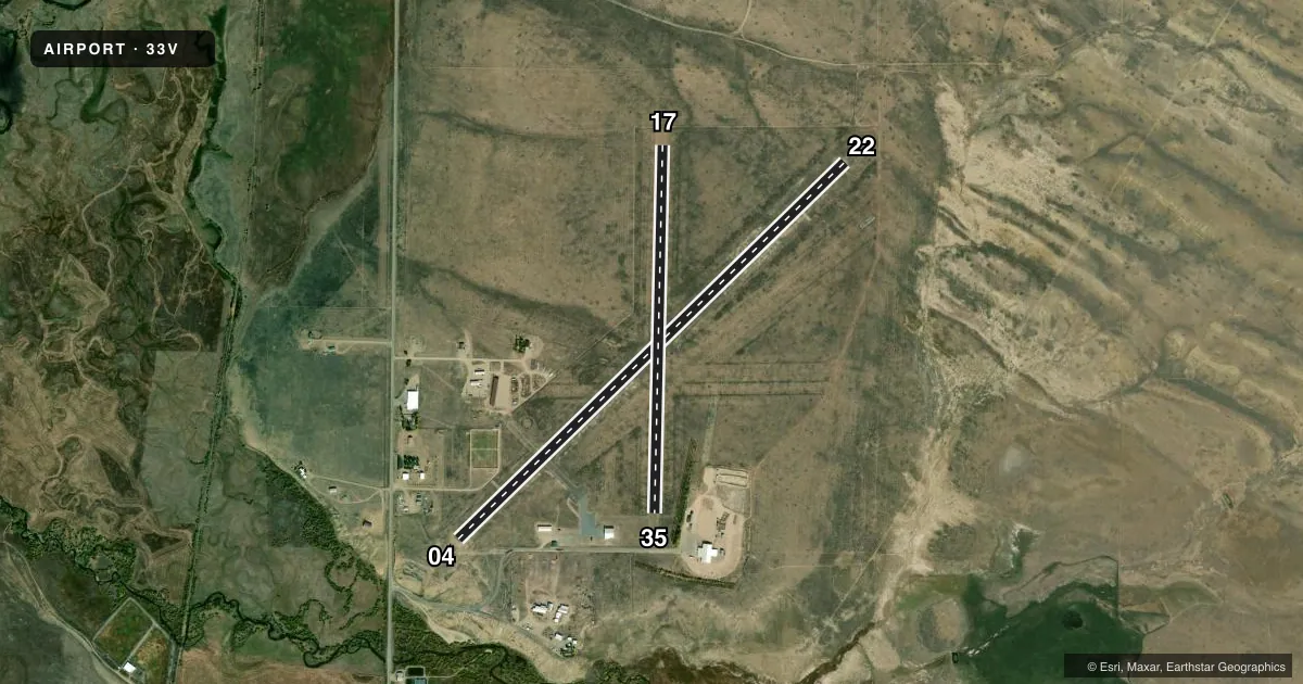
Runways & pattern
Full pagePattern entry · RWY 04
LEFT TRAFFIC| Runway | Heading (°M) | Length | Surface | Traffic |
|---|---|---|---|---|
| 04/22 | 35° / 215° | 5,900 ft | ASPH | Standard L |
| 17/35 | 171° / 351° | 4,020 ft | TURF | Standard L |
Runway end performance
| End | TORA | TODA | ASDA | LDA | VGSI | Approach lights | Obstruction |
|---|---|---|---|---|---|---|---|
| 04 | — | — | — | — | PAPI 4-box left(3°) | — | — |
| 22 | — | — | — | — | PAPI 4-box left(3°) | — | — |
| 17 | — | — | — | — | — | — | 4', fence, 0' from thr, 0' R of cntrln, slope 0 |
| 35 | — | — | — | — | — | — | 10', road, 0' from thr, 0' R of cntrln, slope 0 |
Declared distances in feet. TORA = takeoff run available, TODA = takeoff distance, ASDA = accelerate-stop, LDA = landing distance.
Airport sketch
Runways drawn to scale from FAA survey coordinates, rendered over satellite imagery. Not for navigation.
Approaches & charts
Services on the field
Fuel grades, oxygen, maintenance, ramp storage and lighting — as declared to the FAA by the airport operator.
Fuel & services
- Fuel
- Not available
Ramp & ground
- Transient storage
- Tie-down
- Landing fee
- No fee published
- Customs
- Not available
- Lighting schedule
- SEE RMK
- Beacon schedule
- SS-SR
- Beacon
- White / Green (civil land)(WG)
- Wind indicator
- Lighted
- Segmented circle
- Yes
Fuel & FBOs
Cheapest 100LL and Jet A on the field and nearby. Always confirm with the FBO before taxi.
Airport notes
Surface conditions, obstructions, local procedures, lighting outages and other notes published with each FAA cycle.
General notes
- RDO CTL MODEL ACFT OPS SE CORNER OF ARPT; DEER & ANTELOPE ON RWYS.
- FOR CD CTC DENVER ARTCC AT 303-651-4257.
Lighting notes
- ACTVT PAPI RWY 04 & 22; MIRL RWY 04/22 - CTAF.
Approach & departure obstructions
- 22+4 FT BRUSH 10 FT FM THR.
- 04+20 FT PLINE 660 FT FM RWY END 750 FT L OF CNTRLN; 50 FT DROPOFF 450 FT FM THR.
- 176 FT POLE 100 FT FM THR 10 FT L OF RWY EDGE.
- 35+38 FT TREES 300 FT FM THR 154 FT R OF APCH END; +4 FT FENCE AT THR L & R; FENCE POSTS MKD WITH WORN & FADED YELLOW PAINT; ROAD 24 FT FM THR.
- 17ORANGE CONES.
- 35ORANGE CONES.
- 17FENCE POSTS MKD WITH YELLOW PAINT; WORN & FADED.
Other notes
- MKD WITH YELLOW & BLACK TIRES.
- 1AMGR OR 970-723-4481 OR 970-846-6971.
- 04/22RWY 4-22 ASPH PVMT USBL BUT CRACKED THRUT AND DELAMINATING AT APCH ENDS.
- 17/35RY 17-35 SFC VERY COURSE WITH ANIMAL BURROWS AND VEGITATION THROUGHOUT.
VFR map & nearby airports
VFR sectional. Tap any ICAO chip to open that airport.
Key facts · 33V
Answer card- ICAO
- 33V
- Name
- WALDEN-JACKSON COUNTY
- Location
- WALDEN, COLORADO
- Elevation
- 8,153.8 ft MSL
- Traffic pattern altitude
- 9,153.8 ft MSL (1,000 AGL)
- Control tower
- Non-towered (use CTAF)
- Total runways
- 2
- Longest runway
- 04/22 · 5,900 ft
- Published ILS approaches
- 0
- Published frequencies
- 1
- Magnetic variation
- 10°
- Current flight rules
- VFR
- Current wind
- 000° at 0 kt
- Favored runway now
- –
Walden-Jackson County Airport sits in Walden, Colorado at 8,153.8 ft MSL. It has two runways. The longest is runway 04/22 at 5,900 ft. Runway 17/35 is 4,020 ft turf. There is no control tower. CTAF is 122.9. No ILS approaches are published.
Pattern altitude is not published. Use the standard 1,000 ft AGL pattern unless the current Chart Supplement says otherwise. That puts the light aircraft pattern at 9,153.8 ft MSL based on the field elevation. The airport is high enough that density altitude will matter on warm days. Plan for longer takeoff rolls. Expect weaker climb performance.
Runway 04 has a 20-foot power line 660 ft from the end. There is also a 50-foot dropoff 450 ft from the threshold. Runway 22 has 4-foot brush near the threshold. Runway 35 has trees, a fence and a road close to the approach end. Runway 17 has orange cones, a pole near the edge and the turf surface is reported as very coarse with animal burrows and vegetation. Deer and antelope are present on the runways. Radio control model aircraft operate at the southeast corner of the airport.
There are no on-field FBOs listed. Check with the airport operator or the FBO directly by phone before arrival. PAPI is active on runways 04 and 22. Medium intensity runway lights are on 04 and 22. Use CTAF for lighting. The airport manager can be reached at 970-723-4481 or 970-846-6971.