METAR & TAF KSAA
Current METAR
Observed 12:15Z
KSAA 271215Z AUTO 15009KT 10SM CLR 20/08 A3028 RMK AO2
- Wind
- 150° @ 9 kt
- Visibility
- 10 SM
- Temp / Dew
- 20°C / 8°C
- Altimeter
- 30.28 inHg
- Clouds
- CLR
- Density alt
- 8,851 ft
- Ceiling
- Unlimited
- Rules
- VFR
Airport info & contacts
Manager on record, flight service, ARTCC, attendance schedule and pattern altitude — published by the FAA and refreshed every 28 days.
Location
- From city
- 1 NM SW
- VFR sectional
- CHEYENNE
- ARTCC
- ZDV · DENVER
- NOTAM facility
- CPR (NOTAM-D)
Airport manager
- Name
- LARRY DEANDRADE
- Phone
- 307-326-8344
- Address
- P.O. BOX 1015, SARATOGA WY 82331
Flight service · Hours
- FSS CPR
- CASPER1-800-WX-BRIEF
- Attendance
- 0700-1700
Frequencies
Tap any row to copy the frequency to your clipboard.
Runways & pattern
Full pagePattern entry · RWY 05
LEFT TRAFFICRunway end performance
| End | TORA | TODA | ASDA | LDA | VGSI | Approach lights | Obstruction |
|---|---|---|---|---|---|---|---|
| 05 | — | — | — | — | PAPI 4-box left(3°) | — | — |
| 23 | — | — | — | — | PAPI 4-box left(3°) | — | — |
Declared distances in feet. TORA = takeoff run available, TODA = takeoff distance, ASDA = accelerate-stop, LDA = landing distance.
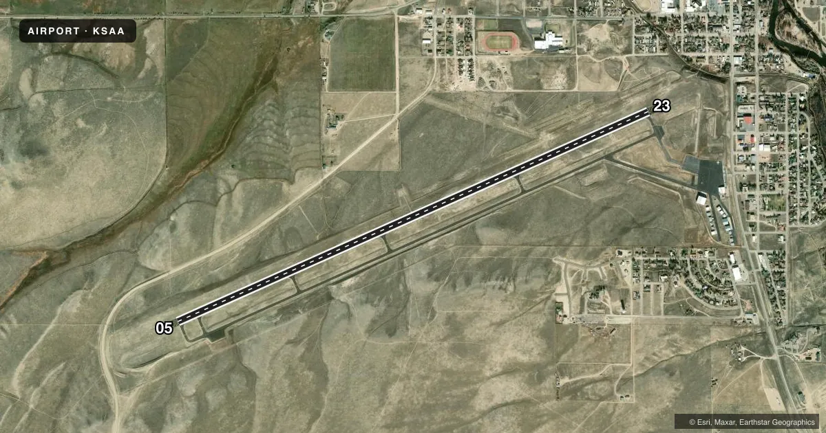
Airport sketch
Runways drawn to scale from FAA survey coordinates, rendered over satellite imagery. Not for navigation.
Approaches & charts
Services on the field
Fuel grades, oxygen, maintenance, ramp storage and lighting — as declared to the FAA by the airport operator.
Fuel & services
- Fuel
- 100LLA
- Oxygen (bottled)
- Not available
- Oxygen (bulk)
- Not available
- Airframe repair
- Not available
- Power plant repair
- Not available
Ramp & ground
- Transient storage
- Tie-down
- Hangar
- Landing fee
- Yes
- Customs
- Not available
- Lighting schedule
- SEE RMK
- Beacon schedule
- SS-SR
- Beacon
- White / Green (civil land)(WG)
- Wind indicator
- Lighted
- Segmented circle
- Yes
Fuel & FBOs
Cheapest 100LL and Jet A on the field and nearby. Always confirm with the FBO before taxi.
Airport notes
Surface conditions, obstructions, local procedures, lighting outages and other notes published with each FAA cycle.
General notes
- WIND SHEAR OVER HIGHWAY APCH END RWY 23.
- FOR CD CTC DENVER ARTCC AT 303-651-4257.
Lighting notes
- ACTVT REIL RWY 5 & 23; PAPI RWY 5 & 23; MIRL RWY 05/23 - CTAF.
Fuel notes
- AFULL SVC FUEL. AFT HRS CALL 307-326-8344.
Other notes
- TURBINE & JET ACFT ONLY. FEES VARY BASED ON CAT OF ACFT.
VFR map & nearby airports
VFR sectional. Tap any ICAO chip to open that airport.
Key facts · KSAA
Answer card- ICAO
- KSAA
- Name
- SHIVELY FLD
- Location
- SARATOGA, WYOMING
- Elevation
- 7,014.2 ft MSL
- Traffic pattern altitude
- 8,014.2 ft MSL (1,000 AGL)
- Control tower
- Non-towered (use CTAF)
- Total runways
- 1
- Longest runway
- 05/23 · 8,801 ft
- Published ILS approaches
- 0
- Published frequencies
- 2
- Magnetic variation
- 12°
- Current flight rules
- VFR
- Current wind
- 150° at 9 kt
- Favored runway now
- RWY 05
Shively Fld sits in Saratoga, Wyoming. The field elevation is 7,014.2 ft MSL. It has one runway, 05/23, which is 8,801 ft long. There is no control tower. CTAF and UNICOM are both 122.8. No ILS approaches are published.
The published pattern altitude is not listed. Use the standard 1,000 ft AGL pattern unless the current Chart Supplement says otherwise. That puts the light piston pattern at about 8,014.2 ft MSL. The runway lighting is set up for night use. Runway end identifier lights, PAPI and medium intensity runway lights are installed on 05/23.
Saratoga Jet Center is on the field. It carries 100LL and Jet A with Prist. Full service fuel is available. After hours fuel calls go to 307-326-8344. The remarks also note wind shear over the highway near the approach end of runway 23. Plan that leg carefully, especially with a tailwind or gusty conditions. Landing fees apply only to turbine and jet aircraft. For clearance delivery, contact Denver ARTCC at 303-651-4257. At this elevation, performance planning matters. Expect high-density-altitude effects, especially on warm days.