METAR & TAF KRWL
Current METAR
Observed 11:53Z
KRWL 271153Z AUTO 21012KT 10SM CLR 22/09 A3024 RMK AO2 SLP114 T02220089 10244 20200 55001
- Wind
- 210° @ 12 kt
- Visibility
- 10 SM
- Temp / Dew
- 22°C / 9°C
- Altimeter
- 30.24 inHg
- Clouds
- CLR
- Density alt
- 8,896 ft
- Ceiling
- Unlimited
- Rules
- VFR
Airport info & contacts
Manager on record, flight service, ARTCC, attendance schedule and pattern altitude — published by the FAA and refreshed every 28 days.
Location
- From city
- 2 NM NE
- VFR sectional
- CHEYENNE
- ARTCC
- ZDV · DENVER
- NOTAM facility
- RWL (NOTAM-D)
Airport manager
- Name
- BOB HEPNER
- Phone
- 307-321-5566
- Address
- 1300 AIRPORT ROAD, RAWLINS WY 82301
Flight service · Hours
- FSS CPR
- CASPER1-800-WX-BRIEF
- Attendance
- MON-FRI · 0700-1900
- SAT-SUN · 0700-1700
Frequencies
Tap any row to copy the frequency to your clipboard.
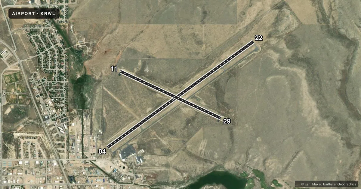
Runways & pattern
Full pagePattern entry · RWY 22
LEFT TRAFFIC| Runway | Heading (°M) | Length | Surface | Traffic |
|---|---|---|---|---|
| 04/22Favored | 44° / 224° | 7,008 ft | ASPH | 04 R |
| 11/29 | 105° / 285° | 4,322 ft | ASPH | 29 R |
Runway end performance
| End | TORA | TODA | ASDA | LDA | VGSI | Approach lights | Obstruction |
|---|---|---|---|---|---|---|---|
| 04 | — | — | — | — | PAPI 4-box left(3°) | — | 29', tank, 756' from thr, 195' R of cntrln, slope 19 |
| 22 | — | — | — | — | PAPI 4-box left(3°) | — | — |
Declared distances in feet. TORA = takeoff run available, TODA = takeoff distance, ASDA = accelerate-stop, LDA = landing distance.
Airport sketch
Runways drawn to scale from FAA survey coordinates, rendered over satellite imagery. Not for navigation.
Approaches & charts
Services on the field
Fuel grades, oxygen, maintenance, ramp storage and lighting — as declared to the FAA by the airport operator.
Fuel & services
- Fuel
- 100LLA
- Oxygen (bottled)
- Not available
- Oxygen (bulk)
- Not available
- Airframe repair
- Not available
- Power plant repair
- Not available
- Other services
- AMB
Ramp & ground
- Transient storage
- Tie-down
- Landing fee
- No fee published
- Customs
- Not available
- Lighting schedule
- SEE RMK
- Beacon schedule
- SS-SR
- Beacon
- White / Green (civil land)(WG)
- Wind indicator
- Lighted
- Segmented circle
- Yes
Fuel & FBOs
Cheapest 100LL and Jet A on the field and nearby. Always confirm with the FBO before taxi.
Airport notes
Surface conditions, obstructions, local procedures, lighting outages and other notes published with each FAA cycle.
General notes
- 7800 FT MTN 3 MILES WEST, 7200 FT MTN 3 MILES SW, 7200 FT MTN 3 MILES NE.
- RWY 11/29 LMTD TO ACFT UP TO 12000 LBS GWT.
- REQ ALL ACFT DEPNG RWY 29 MAKE RIGHT TURNOUT AS SOON AS SAFETY PMTS AFT TKOF TO AVOID HOUSING AREA AND FOR NOISE ABATEMENT.
- BIRDS INVOF ARPT RWYS.
- FOR CD IF UNA TO CTC ON FSS FREQ, CTC DENVER ARTCC AT 303-651-4257.
Lighting notes
- ACTVT REIL RWY 22 & 29; MIRL RWY 04/22 & 11/29 - CTAF. PAPI RWY 04 & 22 OPR CONSLY.
Fuel notes
- 100LLPHONE NR FOR FUEL AFT HRS POSTED ON FBO DOOR.
VFR map & nearby airports
VFR sectional. Tap any ICAO chip to open that airport.
Key facts · KRWL
Answer card- ICAO
- KRWL
- Name
- RAWLINS MUNI/HARVEY FLD
- Location
- RAWLINS, WYOMING
- Elevation
- 6,816.7 ft MSL
- Traffic pattern altitude
- 7,816.7 ft MSL (1,000 AGL)
- Control tower
- Non-towered (use CTAF)
- Total runways
- 2
- Longest runway
- 04/22 · 7,008 ft
- Published ILS approaches
- 0
- Published frequencies
- 2
- Magnetic variation
- 10°
- Current flight rules
- VFR
- Current wind
- 210° at 12 kt
- Favored runway now
- RWY 22
Rawlins Muni/Harvey Fld sits in Rawlins, Wyoming at 6,816.7 ft MSL. It has two asphalt runways. The longest is runway 04/22 at 7,008 ft. Runway 11/29 is 4,322 ft. There is no control tower. CTAF and UNICOM are both 123.0. No ILS approaches are published here.
Pattern altitude is not published. For light piston aircraft, use the standard 1,000 ft AGL unless the current Chart Supplement says otherwise. That puts you at about 7,816.7 ft MSL. This is a high-elevation field, so performance planning matters. Expect thinner air and longer takeoff rolls. The airport also sits near terrain. There is a 7,800-foot mountain 3 miles west. There is a 7,200-foot mountain 3 miles southwest. There is a 7,200-foot mountain 3 miles northeast.
Classic Aviation is on the field. It carries 100LL and Jet A Prist. Runway 22 and 29 have runway end identifier lights. Runways 04/22 and 11/29 have medium intensity lighting controlled by CTAF. PAPI is available on 04 and 22. Runway 29 departures require a right turn out as soon as safety permits to avoid the housing area and for noise abatement. Runway 11/29 is limited to aircraft up to 12,000 pounds gross weight. Birds are also reported in the area.