METAR & TAF 80V
80V does not publish a METAR.
Showing the nearest reporting station: KSAA (SHIVELY FLD) · 39.2 NM away. Conditions at 80V may differ.
METAR · KSAA
Observed 16:35Z
KSAA 261635Z AUTO 09008KT 10SM CLR 28/08 A3034 RMK AO2
- Wind
- 090° @ 8 kt
- Visibility
- 10 SM
- Temp / Dew
- 28°C / 8°C
- Altimeter
- 30.34 inHg
- Clouds
- CLR
- Density alt
- 9,295 ft
- Ceiling
- Unlimited
- Rules
- VFR
Airport info & contacts
Manager on record, flight service, ARTCC, attendance schedule and pattern altitude — published by the FAA and refreshed every 28 days.
Location
- From city
- 2 NM SE
- VFR sectional
- CHEYENNE
- ARTCC
- ZDV · DENVER
- NOTAM facility
- CPR (NOTAM-D)
Airport manager
- Name
- BRIAN LASHLEY
- Phone
- 307-703-0418
- Address
- P. O. BOX 156, MEDICINE BOW WY 82329
Flight service · Hours
- FSS CPR
- CASPER1-800-WX-BRIEF
- Attendance
- Unattended
Frequencies
Tap any row to copy the frequency to your clipboard.
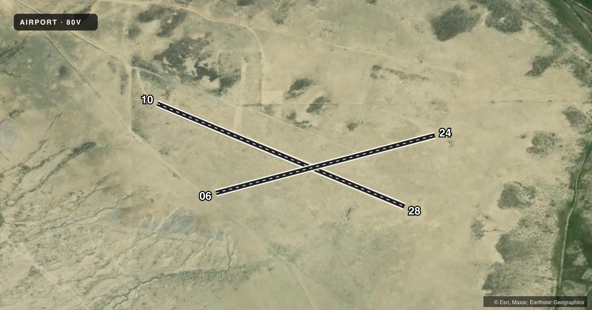
Runways & pattern
Full pagePattern entry · RWY 06
LEFT TRAFFICAirport sketch
Runways drawn to scale from FAA survey coordinates, rendered over satellite imagery. Not for navigation.
Approaches & charts
Services on the field
Fuel grades, oxygen, maintenance, ramp storage and lighting — as declared to the FAA by the airport operator.
Fuel & services
- Fuel
- Not available
- Oxygen (bottled)
- Not available
- Oxygen (bulk)
- Not available
- Airframe repair
- Not available
- Power plant repair
- Not available
Ramp & ground
- Transient storage
- Not published
- Landing fee
- No fee published
- Customs
- Not available
- Wind indicator
- Yes
- Segmented circle
- No
Fuel & FBOs
Cheapest 100LL and Jet A on the field and nearby. Always confirm with the FBO before taxi.
Airport notes
Surface conditions, obstructions, local procedures, lighting outages and other notes published with each FAA cycle.
General notes
- RWY 06/24 - 9 TO 12 INCH BERMS BOTH SIDES; RWY 10/28 GRADED; GOPHER HOLES ON RWY SFCS; RWYS VERY SOFT WHEN WET.
- WILDLIFE INVOF ALL RYS.
- RY 10/28 ONE FOOT DITCH SOUTH OF RY.
- FOR CD CTC DENVER ARTCC AT 303-651-4257.
Approach & departure obstructions
- 06THLD MARKINGS SKEWED AT ANGLE TO RY 6/24.
- 10RY 10/28 MARKED WITH YELLOW 3 FT X 2 FT CONES.
Other notes
- ESTABLISHED PRIOR TO 1959
- 06/24RY IS NO LONGER MAINTAINED.
- 06/24ROUGH & UNEVEN FULL LENGTH; NUMEROUS GOPHER AND BADGER HOLES.
VFR map & nearby airports
VFR sectional. Tap any ICAO chip to open that airport.
Key facts · 80V
Answer card- ICAO
- 80V
- Name
- MEDICINE BOW
- Location
- MEDICINE BOW, WYOMING
- Elevation
- 6,658 ft MSL
- Traffic pattern altitude
- 7,658 ft MSL (1,000 AGL)
- Control tower
- Non-towered (use CTAF)
- Total runways
- 2
- Longest runway
- 10/28 · 3,170 ft
- Published ILS approaches
- 0
- Published frequencies
- 1
- Magnetic variation
- 12°
- Current flight rules
- VFR
- Current wind
- 090° at 8 kt
- Favored runway now
- RWY 06
Medicine Bow Airport (80V) sits in Medicine Bow, Wyoming. Field elevation is 6,658 ft MSL. The airport has two turf-dirt runways. The longest is Runway 10/28 at 3,170 ft. There is no control tower. CTAF is 122.9.
No ILS approaches are published here. Pattern altitude is not published, so use the standard 1,000 ft AGL for light piston operations unless the current Chart Supplement says otherwise. The field has no on-field FBOs listed, so plan ahead for support. Call the airport operator or the FBO directly by phone if you need current fuel or service information.
The published remarks matter here. Runway 06/24 is rough and uneven for the full length. It also has berms on both sides, gopher holes and it is no longer maintained. Runway 10/28 is graded. There is a one foot ditch south of the runway. Wildlife is in the vicinity of all runways. The field was established prior to 1959. This is a high-elevation strip, so performance will be affected. Expect thin air, longer ground roll and a careful look at density altitude before departure. For clearance delivery, contact Denver ARTCC at 303-651-4257.