METAR & TAF KEAN
Current METAR
Observed 09:55Z
KEAN 270955Z AUTO 00000KT 10SM CLR 24/12 A3011 RMK AO2 T02430116
- Wind
- 000° @ 0 kt
- Visibility
- 10 SM
- Temp / Dew
- 24°C / 12°C
- Altimeter
- 30.11 inHg
- Clouds
- CLR
- Density alt
- 6,771 ft
- Ceiling
- Unlimited
- Rules
- VFR
Airport info & contacts
Manager on record, flight service, ARTCC, attendance schedule and pattern altitude — published by the FAA and refreshed every 28 days.
Location
- From city
- 1 NM E
- VFR sectional
- CHEYENNE
- ARTCC
- ZDV · DENVER
- NOTAM facility
- CPR (NOTAM-D)
Airport manager
- Name
- TABITHA ENNIS
- Phone
- 307-322-2962
- Address
- 600 9TH STREET, WHEATLAND WY 82201
Flight service · Hours
- FSS CPR
- CASPER1-800-WX-BRIEF
- Attendance
- Unattended
Frequencies
Tap any row to copy the frequency to your clipboard.
Runways & pattern
Full pagePattern entry · RWY 08
LEFT TRAFFICRunway end performance
| End | TORA | TODA | ASDA | LDA | VGSI | Approach lights | Obstruction |
|---|---|---|---|---|---|---|---|
| 08 | — | — | — | — | PAPI 2-box left(3°) | — | 45', tree, 756' from thr, 47' R of cntrln, slope 12 |
| 26 | — | — | — | — | PAPI 2-box left(3°) | — | — |
Declared distances in feet. TORA = takeoff run available, TODA = takeoff distance, ASDA = accelerate-stop, LDA = landing distance.
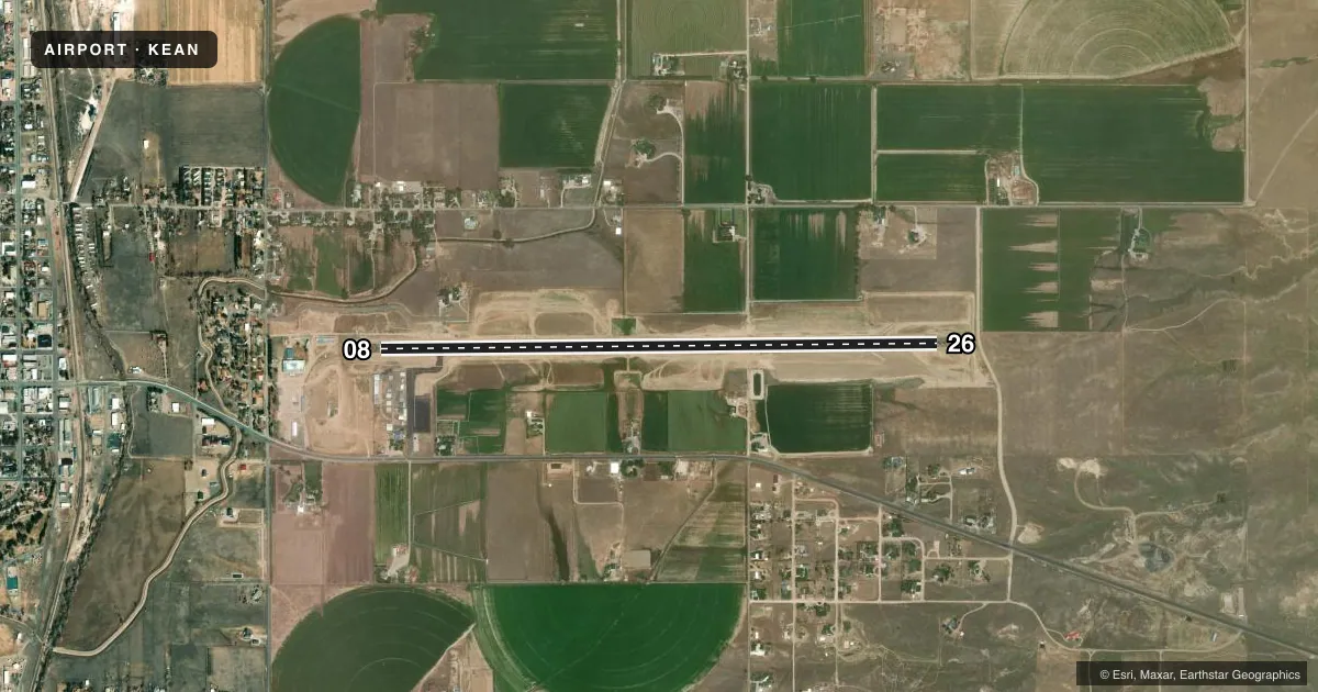
Airport sketch
Runways drawn to scale from FAA survey coordinates, rendered over satellite imagery. Not for navigation.
Approaches & charts
Services on the field
Fuel grades, oxygen, maintenance, ramp storage and lighting — as declared to the FAA by the airport operator.
Fuel & services
- Fuel
- Not available
- Oxygen (bottled)
- Not available
- Oxygen (bulk)
- Not available
- Airframe repair
- Not available
- Power plant repair
- Not available
Ramp & ground
- Transient storage
- Tie-down
- Landing fee
- No fee published
- Customs
- Not available
- Lighting schedule
- SEE RMK
- Beacon schedule
- SS-SR
- Beacon
- White / Green (civil land)(WG)
- Wind indicator
- Lighted
- Segmented circle
- Yes
Fuel & FBOs
Cheapest 100LL and Jet A on the field and nearby. Always confirm with the FBO before taxi.
Airport notes
Surface conditions, obstructions, local procedures, lighting outages and other notes published with each FAA cycle.
Lighting notes
- ACTVT REIL RWY 26; MIRL RWY 08/26 - CTAF. PAPI RWY 08 & 26 OPR CONSLY.
Other notes
- ESTAB PRIOR TO 1959.
- PILOT SUPPLIED ROPES REQUIRED.
VFR map & nearby airports
VFR sectional. Tap any ICAO chip to open that airport.
Key facts · KEAN
Answer card- ICAO
- KEAN
- Name
- PHIFER AIRFIELD
- Location
- WHEATLAND, WYOMING
- Elevation
- 4,779.3 ft MSL
- Traffic pattern altitude
- 5,779.3 ft MSL (1,000 AGL)
- Control tower
- Non-towered (use CTAF)
- Total runways
- 1
- Longest runway
- 08/26 · 5,900 ft
- Published ILS approaches
- 0
- Published frequencies
- 1
- Magnetic variation
- 9°
- Current flight rules
- VFR
- Current wind
- 000° at 0 kt
- Favored runway now
- –
Phifer Airfield (KEAN) sits near Wheatland, Wyoming. The field elevation is 4,779.3 ft MSL. It has one runway. Runway 08/26 is 5,900 ft long and asphalt. There is no control tower, so use CTAF 122.9 for traffic and lighting calls. No ILS approaches are published here.
The published pattern altitude is not listed. For light piston operations, plan on the standard 1,000 ft AGL unless the current Chart Supplement says otherwise. That puts the pattern at about 5,779.3 ft MSL based on the field elevation. Verify the current published value before you go. The airport has been established since before 1959. Runway 26 lighting is pilot-activated on CTAF. The runway end identifier lights for runway 26 also activate on CTAF. Precision approach path indicators for runways 08 and 26 operate continuously.
This is a high-elevation field, so performance planning matters. Expect thinner air than you get at lowland airports. There are no on-field FBOs listed in the facts. Pilot supplied ropes are required. Plan for that on arrival. Check the current Chart Supplement for any other local procedures before flying in.