METAR & TAF 76V
76V does not publish a METAR.
Showing the nearest reporting station: KGUR (CAMP GUERNSEY) · 20.3 NM away. Conditions at 76V may differ.
METAR · KGUR
Observed 15:55Z
KGUR 241555Z AUTO 00000KT 10SM CLR 28/18 A3011 RMK AO2 SLP164 T02760180
- Wind
- 000° @ 0 kt
- Visibility
- 10 SM
- Temp / Dew
- 28°C / 18°C
- Altimeter
- 30.11 inHg
- Clouds
- CLR
- Density alt
- 7,110 ft
- Ceiling
- Unlimited
- Rules
- VFR
Airport info & contacts
Manager on record, flight service, ARTCC, attendance schedule and pattern altitude — published by the FAA and refreshed every 28 days.
Location
- From city
- 1 NM N
- VFR sectional
- CHEYENNE
- ARTCC
- ZDV · DENVER
- NOTAM facility
- CPR (NOTAM-D)
Airport manager
- Name
- TRISTANY HOFFMAN
- Phone
- 307-298-7397
- Address
- PO BOX 396, GLENDO WY 82213
Flight service · Hours
- FSS CPR
- CASPER1-800-WX-BRIEF
- Attendance
- Unattended
Frequencies
Tap any row to copy the frequency to your clipboard.
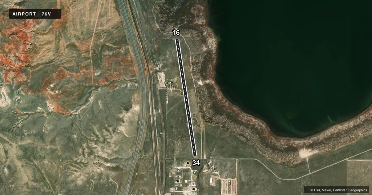
Runways & pattern
Full pagePattern entry · RWY 16
LEFT TRAFFICRunway end performance
| End | TORA | TODA | ASDA | LDA | VGSI | Approach lights | Obstruction |
|---|---|---|---|---|---|---|---|
| 16 | — | — | — | — | — | — | 75', tree, 1197' from thr, 50' R of cntrln, slope 15 |
| 34 | — | — | — | — | — | — | 24', road, 186' from thr, 0' R of cntrln, slope 7 |
Declared distances in feet. TORA = takeoff run available, TODA = takeoff distance, ASDA = accelerate-stop, LDA = landing distance.
Airport sketch
Runways drawn to scale from FAA survey coordinates, rendered over satellite imagery. Not for navigation.
Approaches & charts
Services on the field
Fuel grades, oxygen, maintenance, ramp storage and lighting — as declared to the FAA by the airport operator.
Fuel & services
- Fuel
- Not available
- Oxygen (bottled)
- Not available
- Oxygen (bulk)
- Not available
- Airframe repair
- Not available
- Power plant repair
- Not available
Ramp & ground
- Transient storage
- Tie-down
- Landing fee
- No fee published
- Customs
- Not available
- Wind indicator
- Yes
- Segmented circle
- No
Fuel & FBOs
Cheapest 100LL and Jet A on the field and nearby. Always confirm with the FBO before taxi.
Airport notes
Surface conditions, obstructions, local procedures, lighting outages and other notes published with each FAA cycle.
General notes
- RY 16/34 MUDDY; SLICK & SOFT WHEN WET; OCNL GOPHER HOLES.
- UNRESTRICTED VEHICLE ACCESS.
- OCNL ANTELOPE ON RWY.
- CTCT TOWN HALL 307-735-4242 OR ARPT MANAGER 307-331-5005 PRIOR TO USE FOR SFC CONDITION.
- FOR CD CTC DENVER ARTCC AT 303-651-4257.
Approach & departure obstructions
- 34RWY 34 +5' FENCE 66' FROM THLD 13:1 APCH RATIO. RWY 34 244' HILL 4824' FROM THLD 19:1 APCH RATIO.
Other notes
- EXISTED PRIOR TO 1959.
- STRETCHED CABLE TYPE TIE DOWN NEAR WIND INDICATOR. PILOT SUPPLIED ROPES REQUIRED.
- 16/34FIRST 500 FT RWY 34 END VERY ROUGH.
- 16/34MOWED NATURAL GRASS.
VFR map & nearby airports
VFR sectional. Tap any ICAO chip to open that airport.
Key facts · 76V
Answer card- ICAO
- 76V
- Name
- THOMAS MEML
- Location
- GLENDO, WYOMING
- Elevation
- 4,666 ft MSL
- Traffic pattern altitude
- 5,666 ft MSL (1,000 AGL)
- Control tower
- Non-towered (use CTAF)
- Total runways
- 1
- Longest runway
- 16/34 · 4,397 ft
- Published ILS approaches
- 0
- Published frequencies
- 1
- Magnetic variation
- 12°
- Current flight rules
- VFR
- Current wind
- 000° at 0 kt
- Favored runway now
- –
Thomas Meml is in Glendo, Wyoming. The field elevation is 4,666 ft MSL. It has one runway, 16/34, which is 4,397 ft long. There is no control tower. CTAF is 122.9. No ILS approaches are published.
The pattern altitude is not published. Use the standard 1,000 ft AGL pattern unless the current Chart Supplement says otherwise. That puts the light piston pattern at 5,666 ft MSL. The runway is mowed natural grass with turf-dirt sections. The published remarks say the surface can be muddy, slick and soft when wet. Gopher holes are also noted. The first 500 ft of runway 34 is very rough. There is also a 5-foot fence near the 34 threshold. A hill is farther out on the 34 approach path. Expect wildlife on the runway. Antelope have been reported.
There are no on-field FBOs listed. Contact the airport manager or Town Hall before use for surface condition. Pilot-supplied ropes are required for the stretched cable tie-down near the wind indicator. For clearance delivery, contact Denver ARTCC. This is a non-towered field with a high-elevation grass strip. Check density altitude, runway condition and braking performance before you go.