METAR & TAF KGUR
Current METAR
Observed 15:55Z
KGUR 241555Z AUTO 00000KT 10SM CLR 28/18 A3011 RMK AO2 SLP164 T02760180
- Wind
- 000° @ 0 kt
- Visibility
- 10 SM
- Temp / Dew
- 28°C / 18°C
- Altimeter
- 30.11 inHg
- Clouds
- CLR
- Density alt
- 6,783 ft
- Ceiling
- Unlimited
- Rules
- VFR
Airport info & contacts
Manager on record, flight service, ARTCC, attendance schedule and pattern altitude — published by the FAA and refreshed every 28 days.
Location
- From city
- 1 NM SE
- VFR sectional
- CHEYENNE
- ARTCC
- ZDV · DENVER
- NOTAM facility
- GUR (NOTAM-D)
Airport manager
- Name
- JASON MILLER
- Phone
- 307-292-5635
- Address
- PO BOX 399, BLDG 107, GUERNSEY WY 82214
Flight service · Hours
- FSS CPR
- CASPER1-800-WX-BRIEF
- Attendance
- MON-FRI · 1400-0500Z++
Frequencies
Tap any row to copy the frequency to your clipboard.
Runways & pattern
Full pagePattern entry · RWY 14
LEFT TRAFFICRunway end performance
| End | TORA | TODA | ASDA | LDA | VGSI | Approach lights | Obstruction |
|---|---|---|---|---|---|---|---|
| 14 | — | — | — | — | PAPI 4-box left(3.3°) | — | — |
| 32 | — | — | — | — | PAPI 4-box left(3.3°) | — | — |
Declared distances in feet. TORA = takeoff run available, TODA = takeoff distance, ASDA = accelerate-stop, LDA = landing distance.
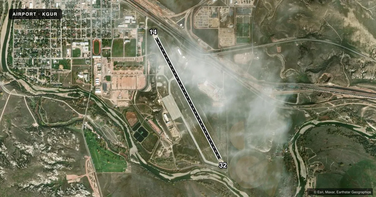
Airport sketch
Runways drawn to scale from FAA survey coordinates, rendered over satellite imagery. Not for navigation.
Approaches & charts
Services on the field
Fuel grades, oxygen, maintenance, ramp storage and lighting — as declared to the FAA by the airport operator.
Fuel & services
- Fuel
- A
- Oxygen (bottled)
- Not available
- Oxygen (bulk)
- Not available
- Airframe repair
- Not available
- Power plant repair
- Not available
Ramp & ground
- Transient storage
- Tie-down
- Hangar
- Landing fee
- No fee published
- Customs
- Not available
- Lighting schedule
- SEE RMK
- Beacon schedule
- SS-SR
- Beacon
- Split White / Green (military)(SWG)
- Wind indicator
- Lighted
- Segmented circle
- Yes
Fuel & FBOs
Cheapest 100LL and Jet A on the field and nearby. Always confirm with the FBO before taxi.
Airport notes
Surface conditions, obstructions, local procedures, lighting outages and other notes published with each FAA cycle.
General notes
- RSTD: EXTV MIL R/W AND C-130/C17 F/W OPR YR ROUND. ACFT WEIGHING MORE THAN 12,500 LBS MUST USE CONC TURN AROUNDS AT EACH THLD INT. ALL C130/C17 ACFT PPR.
- RSTD: ALL TRANS MIL ACFT PPR DSN 307-836-2378; C307-292-5635.
- RSTD: NORTH APN RSTD TO ROTOR WING/FIXED WING UH-60/C-12 OR SMALLER ACFT.
- TFC PAT: F/W 5900 FT R/W 5100 FT, LEFT TFC RY 14, RGT TFC RY 32.
- MISC SMALL ARMS RANGE WITHIN 3NM RADIUS OF GUR, SFC-4000 FT AGL. R7001 A, B, C, D AND R7002 A, B, C 6NM NW, AIRCREWS MUST OBTAIN APVL FM GUERNSEY TWR PRIOR TO ENTERING R7001 AND R7002 WHEN ACTIVE.
- ARNG: NO TRAN MIL MAINT AVBL.
- SERVICE: PPR RQRD FOR ANY ACFT REQUIRING SVCS AND/OR PARKING ON MIL RAMP. CREWS MUST ACT AS THEIR OWN SVCG SUPERVISORS.
- MIGRATORY WATER FOWL, BIRDS, AND DEER ON AND INVOF RWY.
- RWY 14: 48 FT DROP OFF ON AER.
- RWY 32: 12 FT DROP OFF ON AER.
- BLDG 13 FT BLW SFC ELEV LCTD 366 FT NW FR RWY 32 DEP ZONE WI CLEAR ZONE.
- NOISE ABATEMENT AREAS BORDER W OF AFLD.
- RSTD: AIR/GND EQPT AND CRASH RESCUE AVBL AT ETA/ETD IF RQRD WITH PPR.
- TWY D EDGE LGTS OTS INDEF.
- AN/FMQ-23 AUTOMATED OBS SYS IN USE: BRIEFING SVC AVBL FM 25 OWS DSN 228-6598/6599/6588 C520-228-6598.
- SERVICE: FUEL 100LL-NOT AVBL.
- FUEL: JET A AVBL BY PPR.
- CFR AVBL ONLY ON APVD PPR AT ETA/ETD.
Lighting notes
- ACTVT PAPI RWY 14 & 32; MIRL RWY 14/32 - CTAF.
Runway surface & condition
- 14/322S-175 SINGLE TANDEM WHEEL RATING.
Other notes
- ESTAB PRIOR TO 1959.
- CITY HAS LEASE AGREEMENT WITH MILITARY FOR PUBLIC USE.
- 1EXC HOL.
- 14/32RWY 14/32 10 FT ASPH NON-WEIGHT BEARING SHOULDERS.
VFR map & nearby airports
VFR sectional. Tap any ICAO chip to open that airport.
Key facts · KGUR
Answer card- ICAO
- KGUR
- Name
- CAMP GUERNSEY
- Location
- GUERNSEY, WYOMING
- Elevation
- 4,401.8 ft MSL
- Traffic pattern altitude
- 5,401.8 ft MSL (1,000 AGL)
- Control tower
- Towered · 1500-0600Z++ 01 JAN- 31 DEC MON-FRI; CLSD HOL.
- Total runways
- 1
- Longest runway
- 14/32 · 5,060 ft
- Published ILS approaches
- 0
- Published frequencies
- 6
- Magnetic variation
- 11°
- Current flight rules
- VFR
- Current wind
- 000° at 0 kt
- Favored runway now
- –
Camp Guernsey sits near Guernsey, Wyoming. The field elevation is 4,401.8 ft MSL. It has one runway, 14/32, which is 5,060 ft long. The tower is open 1500-0600Z Monday through Friday. It is closed on holidays. No ILS approaches are published here.
Traffic pattern altitude is not published. Use 5,900 ft MSL for fixed-wing traffic. That is 1,000 ft AGL at this field. Runway 14 has a 48-foot drop off on the aerodrome, so brief that on departure and landing. The north apron is restricted to rotor wing and fixed wing UH-60, C-12, or smaller aircraft. Jet A is available by prior permission required. No on-field FBOs are listed, so call the airport operator or the field directly before arrival if you need fuel or ramp details.
Expect military and training activity. All transient military aircraft need prior permission. The published remarks also call out birds, deer and a small arms range within 3 NM of Guernsey that reaches to 4,000 ft AGL. Restricted areas R7001 and R7002 are 6 NM northwest. Get current status from the tower before entering those areas when active. The field uses an AN/FMQ-23 automated observation system, so get a current weather picture before you launch. This is a high-elevation Wyoming airport, so performance planning matters.