METAR & TAF KCYS
Current METAR
Observed 15:53Z
KCYS 271553Z 22009KT 10SM OVC110 26/12 A3022 RMK AO2 RAB31E49 SLP127 P0000 T02560117
- Wind
- 220° @ 9 kt
- Visibility
- 10 SM
- Temp / Dew
- 26°C / 12°C
- Altimeter
- 30.22 inHg
- Clouds
- OVC
- Density alt
- 8,586 ft
- Ceiling
- 11,000 ft AGL
- Rules
- VFR
Airport info & contacts
Manager on record, flight service, ARTCC, attendance schedule and pattern altitude — published by the FAA and refreshed every 28 days.
Location
- From city
- 1 NM N
- VFR sectional
- CHEYENNE
- ARTCC
- ZDV · DENVER
- NOTAM facility
- CYS (NOTAM-D)
Airport manager
- Name
- TIM BRADSHAW
- Phone
- 307-426-4151
- Address
- 1401 AIRPORT PARKWAY, CHEYENNE, WY 82001
Flight service · Hours
- FSS CPR
- CASPER1-800-WX-BRIEF
- Attendance
- 0600-2200
Frequencies
Tap any row to copy the frequency to your clipboard.
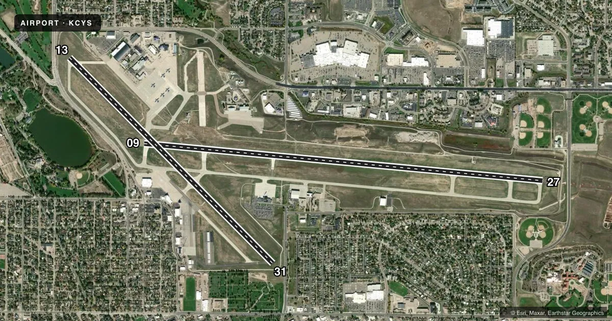
Runways & pattern
Full pagePattern entry · RWY 27
LEFT TRAFFIC| Runway | Heading (°M) | Length | Surface | Traffic |
|---|---|---|---|---|
| 09/27Favored | 85° / 265° | 9,270 ft | CONC | Standard L |
| 13/31 | 125° / 305° | 6,690 ft | ASPH | Standard L |
Runway end performance
| End | TORA | TODA | ASDA | LDA | VGSI | Approach lights | Obstruction |
|---|---|---|---|---|---|---|---|
| 09 | 9,270' | 9,270' | 8,595' | 7,985' | PAPI 4-box left(3°) | — | — |
| 27 | 9,270' | 9,270' | 8,660' | 7,985' | PAPI 4-box left(3°) | MALSR | — |
| 13 | 5,530' | 6,690' | 5,890' | 4,830' | PAPI 4-box left(3°) | — | 9', fence, 200' from thr, 225' R of cntrln, slope 0 |
| 31 | 6,690' | 6,690' | 6,040' | 4,880' | PAPI 4-box left(3°) | — | — |
Declared distances in feet. TORA = takeoff run available, TODA = takeoff distance, ASDA = accelerate-stop, LDA = landing distance.
Airport sketch
Runways drawn to scale from FAA survey coordinates, rendered over satellite imagery. Not for navigation.
Approaches & charts
ILS · 1
Services on the field
Fuel grades, oxygen, maintenance, ramp storage and lighting — as declared to the FAA by the airport operator.
Fuel & services
- Fuel
- 100LLAA1
- Oxygen (bottled)
- Not available
- Oxygen (bulk)
- HIGH/LOW
- Airframe repair
- Minor
- Power plant repair
- Minor
- Other services
- AFRT,AMB,CARGO,CHTR,INSTR,RNTL
Ramp & ground
- Transient storage
- Tie-down
- Hangar
- Landing fee
- No fee published
- Lighting schedule
- SEE RMK
- Beacon schedule
- SS-SR
- Beacon
- White / Green (civil land)(WG)
- Wind indicator
- Lighted
- Segmented circle
- Yes
Fuel & FBOs
Cheapest 100LL and Jet A on the field and nearby. Always confirm with the FBO before taxi.
Airport notes
Surface conditions, obstructions, local procedures, lighting outages and other notes published with each FAA cycle.
General notes
- RCR AVBL ON REQ FM ATCT 0600-2200 30 MIN PRIOR NOTICE REQUIRED.
- BIRD ACTIVITY INVOF ARPT.
- PILOTS SHOULD AVOID F.E. WARREN AFHP AT ALL TIMES.
- MILITARY: RSTD: ANG PPR REQ TO PRK ON MIL RAMP.
- MILITARY: ANG: LMTD DEICE SVC AVBL TO MIL ACFT WITH ANG PPR. ALL TRAN ACFT RQR PPR MIN 72 HR PRIOR TO ARR. AIRCREWS WITH APV PPR THAT DEVIATE FR COORD ARR TIME BY MORE THAN ONE HR MUST CTC AMOPS ASAP. PPR DSN388-6355/6879, C307-772-6355/6879.
- HEAVY COPTER TFC 2 NM SW OF ARPT, SFC TO 1000 FT DUR DALGT, WEEKDAYS.
- RSTD: TWY C CLSD NORTH OF TWY F, TWY D, AND G CLSD INDEFLY.
- CAUTION: TWY B1, C AND E HOLD SHORT LINES FOR ALL RWYS
- BASH PHASE II, INCR BIRD HAZ MAY-SEP.
- MILITARY: INFO: SEE FLIP AP/1 SUPPLEMENTARY ARPT INFO.
- MILITARY: ANG: BASE OPS NML OPR 1300-2230Z++ MON-THU, LTD FRI, CLSD SAT, SUN AND HOL.
- MILITARY: ANG: ALL TRAN ACFT CTC ANG COWBOY OPS 15 MIN PRIOR TO LDG.
- MILITARY: ANG: COMD POST DSN388-6470, C307-772-6470 NML OPR 1300-2230Z++ MON-THU, LTD FRI, CLSD SAT, SUN, AND HOL.
- MILITARY: SVC: FUEL: A++(MIL) AVBL AT ANG
- MILITARY: ANG: NO TWY EDGE LGT ON TWY C & TWY F. NSTD WHITE AGE BOX MKGS ON APN. NST FIRE LANE MRKS ON APN.
- MILITARY: ANG: CSTMS/AG - SVC UNAVBL.
- RWY: RWY 09/27 & RWY 13/31 HAVE PAINTED ASSAULT LNDG ZONE MKGS.
- FOR CD CTC CHEYENNE APCH AT 307-772-6032, WHEN APCH CLSD CTC DENVER ARTCC AT 303-651-4257.
- EMERG AFT TWR CLSD CTC ARFF 307-772-6338.
Lighting notes
- ACTVT MALSR RWY 27; REIL RWY 09, 13, 31; PAPI RWY 09, 27, 13, 31; HIRL RWY 09/27; MIRL RWY 13/31 - CTAF
Fuel notes
- 100LLAFTER HOURS FUEL CALL 307-634-7079.
Runway surface & condition
- 09/27PCR VALUE: 577/R/B/W/T
- 13/31PCR VALUE: 230/F/C/X/T
Approach & departure obstructions
- 13+9 FT FENCE, 199 FT FM RWY END, 400 FT RGT.
- 09APCH RATIO 17:1 FM DSPLCD THR.
Other notes
- PPR FOR UNSKED ACR OPNS WHEN ATCT CLSD CALL AMGR 307-638-3872.
- TIEDOWN FEE.
VFR map & nearby airports
VFR sectional. Tap any ICAO chip to open that airport.
Key facts · KCYS
Answer card- ICAO
- KCYS
- Name
- CHEYENNE RGNL/JERRY OLSON FLD
- Location
- CHEYENNE, WYOMING
- Elevation
- 6,159.9 ft MSL
- Traffic pattern altitude
- 7,159.9 ft MSL (1,000 AGL)
- Control tower
- Towered · 0600-2200
- Total runways
- 2
- Longest runway
- 09/27 · 9,270 ft
- Published ILS approaches
- 1
- Published frequencies
- 12
- Magnetic variation
- 10°
- Current flight rules
- VFR
- Current wind
- 220° at 9 kt
- Favored runway now
- RWY 27
Cheyenne Rgnl/Jerry Olson Fld sits in Cheyenne, Wyoming at 6,159.9 ft MSL. It has two runways. The longest is 09/27 at 9,270 ft. Runway 13/31 is 6,690 ft. The tower is open 0600-2200. There is one ILS approach. It serves runway 27. Pattern altitude is not published in the facts, so use the current FAA Chart Supplement before you fly. This is a high-elevation field, so performance planning matters. Expect thinner air and longer takeoff rolls than you would at a low field.
Legend AeroServe is on the field. It carries AVGAS 100LL and Jet A Prist. After-hours fuel is available by calling the number in the Chart Supplement or the FBO directly. Published remarks also note bird activity in the area. Heavy helicopter traffic occurs 2 NM southwest of the airport from the surface to 1,000 ft during daylight hours on weekdays. Transient aircraft need prior permission at least 72 hours before arrival. Prior permission is also required to park on the military ramp. If you are headed in with a large aircraft or a military mission, check the current FAA Chart Supplement and coordinate with the airport operator before departure.