METAR & TAF KIBM
Current METAR
Observed 13:15Z
KIBM 271315Z AUTO 30007KT 10SM SCT120 25/13 A3012 RMK AO2 T02500131
- Wind
- 300° @ 7 kt
- Visibility
- 10 SM
- Temp / Dew
- 25°C / 13°C
- Altimeter
- 30.12 inHg
- Clouds
- SCT
- Density alt
- 7,060 ft
- Ceiling
- Unlimited
- Rules
- VFR
Airport info & contacts
Manager on record, flight service, ARTCC, attendance schedule and pattern altitude — published by the FAA and refreshed every 28 days.
Location
- From city
- 3 NM S
- VFR sectional
- CHEYENNE
- ARTCC
- ZDV · DENVER
- NOTAM facility
- IBM (NOTAM-D)
Airport manager
- Name
- RYAN MCELROY
- Phone
- (308) 249-2649
- Address
- 223 S CHESTNUT STREET, KIMBALL NE 69145-1219
Flight service · Hours
- FSS OLU
- COLUMBUS1-800-WX-BRIEF
- Attendance
- UNATTENDED
Frequencies
Tap any row to copy the frequency to your clipboard.
Runways & pattern
Full pagePattern entry · RWY 28
LEFT TRAFFICRunway end performance
| End | TORA | TODA | ASDA | LDA | VGSI | Approach lights | Obstruction |
|---|---|---|---|---|---|---|---|
| 10 | — | — | — | — | PAPI 2-box left(3°) | — | — |
| 28 | — | — | — | — | PAPI 2-box left(3°) | — | — |
Declared distances in feet. TORA = takeoff run available, TODA = takeoff distance, ASDA = accelerate-stop, LDA = landing distance.
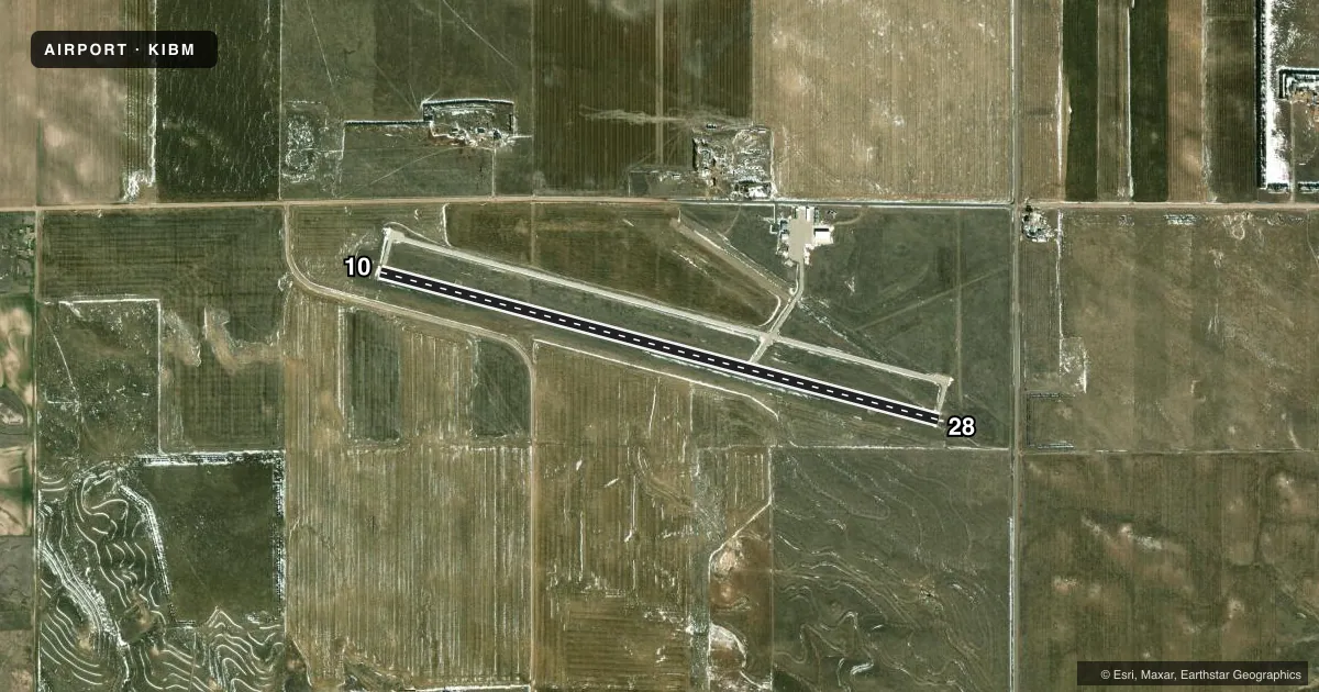
Airport sketch
Runways drawn to scale from FAA survey coordinates, rendered over satellite imagery. Not for navigation.
Approaches & charts
Services on the field
Fuel grades, oxygen, maintenance, ramp storage and lighting — as declared to the FAA by the airport operator.
Fuel & services
- Fuel
- 100LLA
- Oxygen (bottled)
- Not available
- Oxygen (bulk)
- Not available
- Power plant repair
- Minor
- Other services
- INSTR,RNTL
Ramp & ground
- Transient storage
- Tie-down
- Landing fee
- No fee published
- Customs
- Not available
- Lighting schedule
- SEE RMK
- Beacon schedule
- SS-SR
- Beacon
- White / Green (civil land)(WG)
- Wind indicator
- Yes
- Segmented circle
- Yes
Fuel & FBOs
Cheapest 100LL and Jet A on the field and nearby. Always confirm with the FBO before taxi.
Airport notes
Surface conditions, obstructions, local procedures, lighting outages and other notes published with each FAA cycle.
General notes
- FOR CD CTC DENVER ARTCC AT 303-651-4257.
Lighting notes
- ACTVT REIL RWY 10 & 28; PAPI RWY 10 & 28; MIRL RWY 10/28 - CTAF.
Approach & departure obstructions
- 10RWY 10 CLNC SLOPE 36:1 TO RWY THR DUE TO ROAD 641 FT FM & 12 FT ABV RWY END, 316 RIGHT.
- 28RWY 28 CLNC SLOPE 43:1 TO RWY THR DUE TO ROAD 768 FT FM & 13 FT ABV RWY END, 335 R.
Other notes
- THIS AIRPORT HAS BEEN SURVEYED BY THE NATIONAL GEODETIC SURVEY.
- 1CALL (308) 249-2649 OR (970) 217-1778.
VFR map & nearby airports
VFR sectional. Tap any ICAO chip to open that airport.
Key facts · KIBM
Answer card- ICAO
- KIBM
- Name
- KIMBALL MUNI/ROBERT E ARRAJ FLD
- Location
- KIMBALL, NEBRASKA
- Elevation
- 4,925.5 ft MSL
- Traffic pattern altitude
- 5,925.5 ft MSL (1,000 AGL)
- Control tower
- Non-towered (use CTAF)
- Total runways
- 1
- Longest runway
- 10/28 · 6,199 ft
- Published ILS approaches
- 0
- Published frequencies
- 2
- Magnetic variation
- 10°
- Current flight rules
- VFR
- Current wind
- 300° at 7 kt
- Favored runway now
- RWY 28
KIMBALL MUNI/ROBERT E ARRAJ FLD sits in Kimball, Nebraska. Field elevation is 4,925.5 ft MSL. The airport has one runway. Runway 10/28 is 6,199 ft of concrete, which gives you a solid strip for a high-elevation stop in western Nebraska. The field is not towered. CTAF and UNICOM are both 122.8.
No ILS approaches are published here. The published pattern altitude is not listed, so use the standard 1,000 ft AGL pattern unless local procedures say otherwise. That puts the light-piston pattern at about 5,925.5 ft MSL. Runway 10/28 has REIL lighting, PAPI and medium intensity runway lights that are controlled by CTAF. That helps after sunset. You still want to verify the lighting setup before you go.
Kimball Municipal Airport is on the field. It carries AVGAS 100LL and Jet A. Call the airport at (308) 249-2649 for current details. Published remarks also note road obstructions near both runway ends. Runway 10 has a road close to the threshold. Runway 28 has a road beyond the end as well. This is a high-elevation airport, so expect thinner air and plan performance with that in mind. For clearance delivery, contact Denver ARTCC at 303-651-4257.