METAR & TAF KSTK
Current METAR
Observed 14:55Z
KSTK 271455Z AUTO 36009KT 10SM CLR 30/16 A3002 RMK AO2
- Wind
- 360° @ 9 kt
- Visibility
- 10 SM
- Temp / Dew
- 30°C / 16°C
- Altimeter
- 30.02 inHg
- Clouds
- CLR
- Density alt
- 6,683 ft
- Ceiling
- Unlimited
- Rules
- VFR
Airport info & contacts
Manager on record, flight service, ARTCC, attendance schedule and pattern altitude — published by the FAA and refreshed every 28 days.
Location
- From city
- 3 NM W
- VFR sectional
- CHEYENNE
- ARTCC
- ZDV · DENVER
- NOTAM facility
- DEN (NOTAM-D)
Airport manager
- Name
- CHARLIE MAY
- Phone
- 970-522-0417
- Address
- 16562 HWY 14, STERLING CO 80751
Flight service · Hours
- FSS DEN
- DENVER1-800-WX-BRIEF
- Attendance
- 0700-1600
Frequencies
Tap any row to copy the frequency to your clipboard.
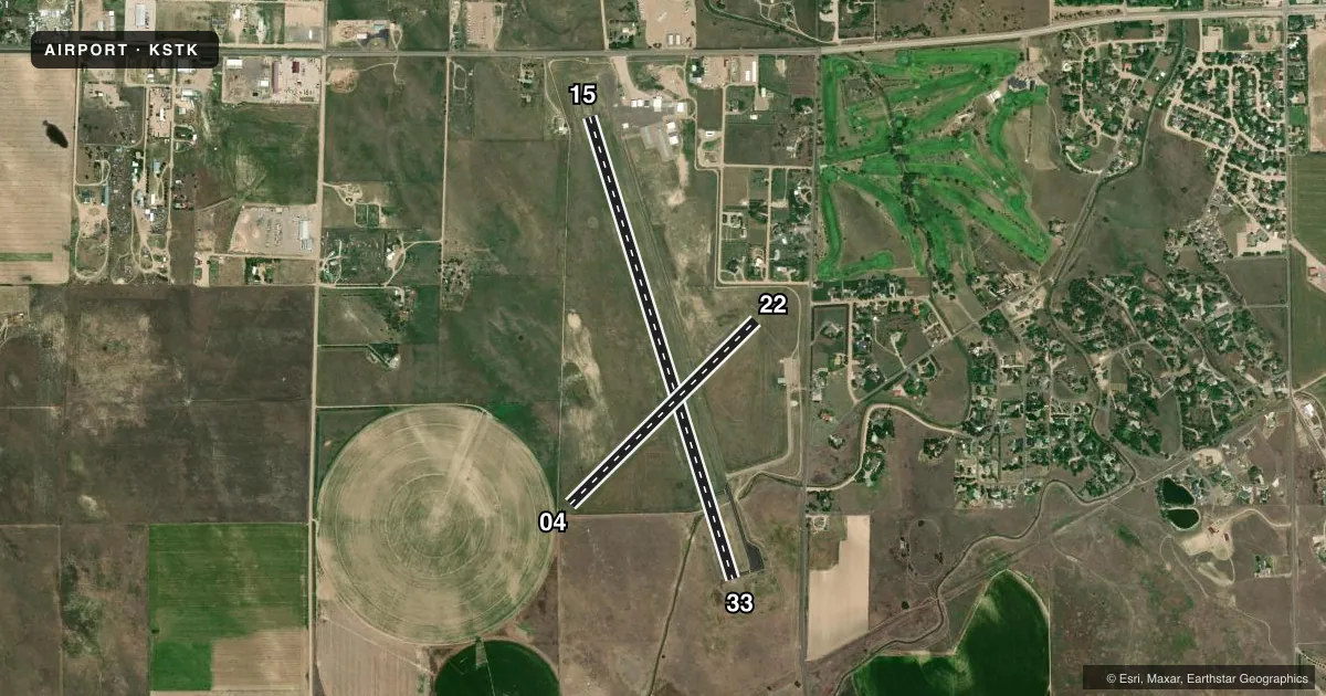
Runways & pattern
Full pagePattern entry · RWY 33
LEFT TRAFFIC| Runway | Heading (°M) | Length | Surface | Traffic |
|---|---|---|---|---|
| 15/33Favored | 155° / 335° | 5,201 ft | ASPH | Standard L |
| 04/22 | 37° / 217° | 2,809 ft | TURF-GRVL | Standard L |
Runway end performance
| End | TORA | TODA | ASDA | LDA | VGSI | Approach lights | Obstruction |
|---|---|---|---|---|---|---|---|
| 15 | — | — | — | — | PAPI 2-box left(3°) | — | 31', tree, 608' from thr, 266' R of cntrln, slope 13 |
| 33 | — | — | — | — | PAPI 2-box left(3°) | — | — |
| 04 | — | — | — | — | — | — | 16', road, 139' from thr, 7' R of cntrln, slope 8 |
| 22 | — | — | — | — | — | — | 48', tree, 614' from thr, 34' R of cntrln, slope 12 |
Declared distances in feet. TORA = takeoff run available, TODA = takeoff distance, ASDA = accelerate-stop, LDA = landing distance.
Airport sketch
Runways drawn to scale from FAA survey coordinates, rendered over satellite imagery. Not for navigation.
Approaches & charts
Services on the field
Fuel grades, oxygen, maintenance, ramp storage and lighting — as declared to the FAA by the airport operator.
Fuel & services
- Fuel
- 100LLA
- Other services
- AGRI
Ramp & ground
- Transient storage
- Tie-down
- Hangar
- Landing fee
- No fee published
- Customs
- Not available
- Lighting schedule
- SEE RMK
- Beacon schedule
- SS-SR
- Beacon
- White / Green (civil land)(WG)
- Wind indicator
- Lighted
- Segmented circle
- Yes
Fuel & FBOs
Cheapest 100LL and Jet A on the field and nearby. Always confirm with the FBO before taxi.
Airport notes
Surface conditions, obstructions, local procedures, lighting outages and other notes published with each FAA cycle.
General notes
- RWY 04 DEP HAS 8 FT FENCE 155 FT FM DEP END OF RWY.
- TWY & TRML TIEDOWN AREA MKD WITH BLUE REFLECTORS.
- AEROBATIC OPS ON AND INVOF ARPT.
- BE ALERT; INTENSIVE USAF STUDENT TRG INVOF KCOS & KPUB ARPRTS.
- INTENSIVE AG OPS MAR-SEPT.
- RWY 4/22 SOFT AND ROUGH WHEN WET.
- FOR CD CTC DENVER ARTCC AT 303-651-4257.
Lighting notes
- ACTVT REIL RWY 15 & 33; MIRL RWY 15/33 - CTAF. PAPI RWY 15 & 33 OPR CONSLY. INCR MIRL INTST - CTAF.
Approach & departure obstructions
- 04MKG TYPE - COND: RWY 04/22 ENDS MKD WITH RED/GREEN REFLECTORS.
Other notes
- 1FOR AFT HRS SVC CALL 970-520-2325.
- 04/22VARMINT HOLES NEAR RWY 04 END.
VFR map & nearby airports
VFR sectional. Tap any ICAO chip to open that airport.
Key facts · KSTK
Answer card- ICAO
- KSTK
- Name
- STERLING MUNI
- Location
- STERLING, COLORADO
- Elevation
- 4,037.6 ft MSL
- Traffic pattern altitude
- 5,037.6 ft MSL (1,000 AGL)
- Control tower
- Non-towered (use CTAF)
- Total runways
- 2
- Longest runway
- 15/33 · 5,201 ft
- Published ILS approaches
- 0
- Published frequencies
- 2
- Magnetic variation
- 8°
- Current flight rules
- VFR
- Current wind
- 360° at 9 kt
- Favored runway now
- RWY 33
Sterling Muni is in Sterling, Colorado. The field elevation is 4,037.6 ft MSL. It has two runways. The longest is runway 15/33 at 5,201 ft. There is no control tower. CTAF and UNICOM are both 122.8. No ILS approaches are published.
Pattern altitude is not published, so plan on the standard 1,000 ft AGL for light piston traffic unless the current Chart Supplement says otherwise. The on-field FBO is Sterling Municipal Airport. It carries 100LL and Jet A. Call (970) 522-0417 for current service details.
A few operational notes matter here. Aerobatic operations occur on and near the airport. Runway 15 and 33 have runway end identifier lights. They also have medium intensity runway lights and PAPI, with lighting controlled on CTAF. Runway 04/22 has red and green reflectors at the ends. Runway 04/22 is soft and rough when wet. There are varmint holes near the runway 04 end. Runway 04 departure also has an 8 ft fence 155 ft from the departure end.
This is a high-elevation airport, so expect density altitude to matter on warm days. Intensive agricultural operations run from March through September. Be alert for student military training traffic in the region near KCOS and KPUB. For clearance delivery, contact Denver ARTCC.