METAR & TAF 7V5
7V5 does not publish a METAR.
Showing the nearest reporting station: KFMM (FORT MORGAN MUNI) · 11.3 NM away. Conditions at 7V5 may differ.
METAR · KFMM
Observed 01:15Z
KFMM 240115Z AUTO 05010KT 10SM CLR 25/16 A3016 RMK AO2
- Wind
- 050° @ 10 kt
- Visibility
- 10 SM
- Temp / Dew
- 25°C / 16°C
- Altimeter
- 30.16 inHg
- Clouds
- CLR
- Density alt
- 6,210 ft
- Ceiling
- Unlimited
- Rules
- VFR
Airport info & contacts
Manager on record, flight service, ARTCC, attendance schedule and pattern altitude — published by the FAA and refreshed every 28 days.
Location
- From city
- 3 NM E
- VFR sectional
- CHEYENNE
- ARTCC
- ZDV · DENVER
- NOTAM facility
- DEN (NOTAM-D)
Airport manager
- Name
- CITY OF BRUSH/TYLER PURVIS
- Phone
- 970-847-8029
- Address
- PO BOX 363, BRUSH CO 80723
Flight service · Hours
- FSS DEN
- DENVER1-800-WX-BRIEF
- Attendance
- IREG
Frequencies
Tap any row to copy the frequency to your clipboard.
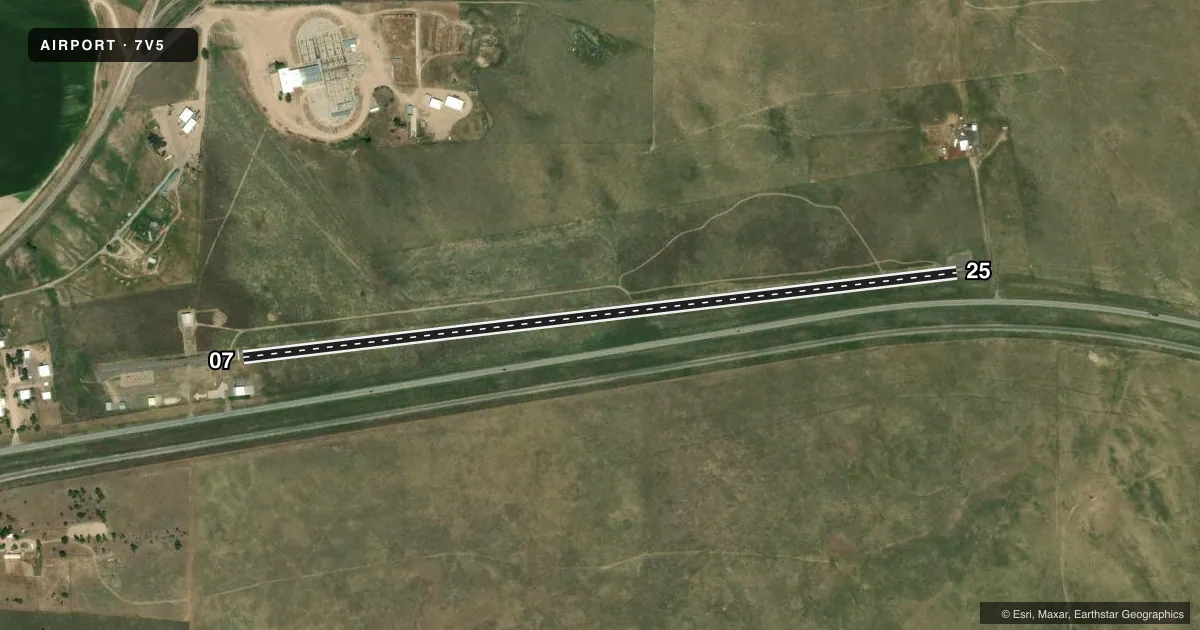
Runways & pattern
Full pagePattern entry · RWY 07
LEFT TRAFFICRunway end performance
| End | TORA | TODA | ASDA | LDA | VGSI | Approach lights | Obstruction |
|---|---|---|---|---|---|---|---|
| 07 | — | — | — | — | — | — | 39', tree, 1269' from thr, 6' R of cntrln, slope 27 |
| 25 | — | — | — | — | — | — | 11', fence, 362' from thr, 0' R of cntrln, slope 14 |
Declared distances in feet. TORA = takeoff run available, TODA = takeoff distance, ASDA = accelerate-stop, LDA = landing distance.
Airport sketch
Runways drawn to scale from FAA survey coordinates, rendered over satellite imagery. Not for navigation.
Approaches & charts
Services on the field
Fuel grades, oxygen, maintenance, ramp storage and lighting — as declared to the FAA by the airport operator.
Fuel & services
- Fuel
- Not available
Ramp & ground
- Transient storage
- Tie-down
- Landing fee
- No fee published
- Customs
- Not available
- Lighting schedule
- SEE RMK
- Wind indicator
- Yes
- Segmented circle
- No
Fuel & FBOs
Cheapest 100LL and Jet A on the field and nearby. Always confirm with the FBO before taxi.
Airport notes
Surface conditions, obstructions, local procedures, lighting outages and other notes published with each FAA cycle.
General notes
- RY 07 END - 810 FT ALIGNED TAXIWAY WITH RY - FOR TAXIING ONLY.
- RY 25 HAS +4 FT FENCE AT VARIOUS TERRAIN HEIGHTS AS CLOSE AS 70 FT L OF CNTRLN FULL LENGTH OF RY.
- HIGH TENSION POWERLINES WITHIN 1 MI S OF ARPT.
- LARGE WASHOUT AT SW CORNER OF WEST ALIGNED TWY.
- UNLGTD 320 FT TWR 3 MILES EAST OF ARPT.
- BE ALERT; INTENSIVE USAF STUDENT TRAINING IN VICINITY OF COLORADO SPRINGS & PUEBLO COLORADO.
- FOR CD CTC DENVER ARTCC AT 303-651-4257.
Lighting notes
- DUSK-DAWN, ACTVT LIRL RWY 07/25 5 TIMES - 8 TIMES OFF - CTAF.
Runway surface & condition
- 07/25NSTD LIRL; ONE THLD LGT EACH SIDE OF RWY BOTH ENDS; RWY 25 LGTD THLD DISPLACED 195 FT FOR NIGHT OPNS.
Approach & departure obstructions
- 255 FT FENCE 95 FT FM END OF PAVEMENT OB; 7 FT FENCE 70 FT LEFT OF AND PARL TO CNTRLN; 8 FT SIGN 150 FT FM END OF PAVEMENT, 60 FT LEFT OF CNTRLN.
- 07RWY MKGS BADLY WORN AND FADED.
- 25RWY MKGS BADLY WORN AND FADED.
- 25THLD MKG BEGINS 195 FT WEST OF PAVEMENT END.
- 2510 FT FENCE 550 FT FM DTHR, OB; 34:1 SLOPE TO DTHR.
Other notes
- EXISTED PRIOR TO 1959.
- 1FOR SVC CALL 970-842-5279 OR 907-842-5777.
VFR map & nearby airports
VFR sectional. Tap any ICAO chip to open that airport.
Key facts · 7V5
Answer card- ICAO
- 7V5
- Name
- BRUSH MUNI
- Location
- BRUSH, COLORADO
- Elevation
- 4,280 ft MSL
- Traffic pattern altitude
- 5,280 ft MSL (1,000 AGL)
- Control tower
- Non-towered (use CTAF)
- Total runways
- 1
- Longest runway
- 07/25 · 4,300 ft
- Published ILS approaches
- 0
- Published frequencies
- 2
- Magnetic variation
- 11°
- Current flight rules
- VFR
- Current wind
- 050° at 10 kt
- Favored runway now
- RWY 07
Brush Muni is in Brush, Colorado. The field elevation is 4,280 ft MSL. It has one runway, 07/25, which is 4,300 ft long and asphalt. This is an uncontrolled airport with CTAF and UNICOM both on 122.8. No ILS approaches are published here.
The pattern altitude is not published, so use the standard 1,000 ft AGL for light piston operations unless the current FAA Chart Supplement says otherwise. That puts the traffic pattern at 5,280 ft MSL. The runway has nonstandard low-intensity lights. Runway 25 has a displaced threshold for night use. Runway markings are badly worn and faded on both ends. That matters here because the pavement edges and threshold cues can be hard to pick up fast.
There are no on-field FBOs listed. For service, call 970-842-5279 or 907-842-5777. For clearance delivery, contact Denver ARTCC at 303-651-4257. Watch the published obstructions. There is a fence near runway 25, plus a sign close to the runway end. There is also a high tension powerline south of the airport. The west aligned taxiway has a large washout. If you are new to the field, brief the runway 25 departure carefully and verify current conditions before you go.