METAR & TAF 18V
18V does not publish a METAR.
Showing the nearest reporting station: KDEN (DENVER INTL) · 14.5 NM away. Conditions at 18V may differ.
METAR · KDEN
Observed 15:53Z
KDEN 271553Z 34006KT 10SM FEW080 SCT100 BKN140 27/14 A3017 RMK AO2 SLP115 T02720139
- Wind
- 340° @ 6 kt
- Visibility
- 10 SM
- Temp / Dew
- 27°C / 14°C
- Altimeter
- 30.17 inHg
- Clouds
- BKN
- Density alt
- 7,287 ft
- Ceiling
- 14,000 ft AGL
- Rules
- VFR
Airport info & contacts
Manager on record, flight service, ARTCC, attendance schedule and pattern altitude — published by the FAA and refreshed every 28 days.
Location
- From city
- 3 NM NW
- VFR sectional
- CHEYENNE
- ARTCC
- ZDV · DENVER
- NOTAM facility
- DEN (NOTAM-D)
Airport manager
- Name
- ERIN SHOFFIT
- Phone
- 720-914-3854
- Address
- 7507 CO RD 39, FORT LUPTON CO 80621
Flight service · Hours
- FSS DEN
- DENVER1-800-WX-BRIEF
- Attendance
- SR-SS
Frequencies
Tap any row to copy the frequency to your clipboard.
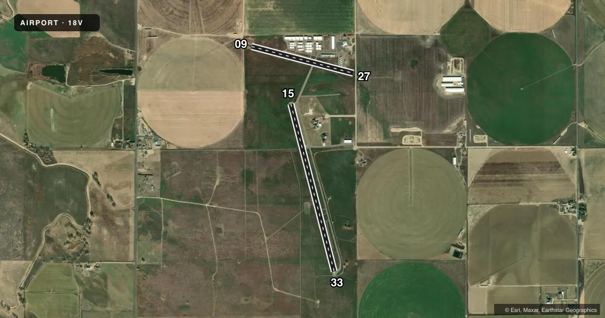
Runways & pattern
Full pagePattern entry · RWY 33
LEFT TRAFFIC| Runway | Heading (°M) | Length | Surface | Traffic |
|---|---|---|---|---|
| 15/33Favored | 154° / 334° | 4,100 ft | ASPH | Standard L |
| 09/27 | 94° / 274° | 2,500 ft | TURF-GRVL | Standard L |
Runway end performance
| End | TORA | TODA | ASDA | LDA | VGSI | Approach lights | Obstruction |
|---|---|---|---|---|---|---|---|
| 09 | — | — | — | — | — | — | 46', tree, 87' from thr, 0' R of cntrln, slope 1 |
| 27 | — | — | — | — | — | — | 17', road, 64' from thr, 0' R of cntrln, slope 3 |
Declared distances in feet. TORA = takeoff run available, TODA = takeoff distance, ASDA = accelerate-stop, LDA = landing distance.
Airport sketch
Runways drawn to scale from FAA survey coordinates, rendered over satellite imagery. Not for navigation.
Approaches & charts
Services on the field
Fuel grades, oxygen, maintenance, ramp storage and lighting — as declared to the FAA by the airport operator.
Fuel & services
- Fuel
- 100LL
- Airframe repair
- Minor
- Power plant repair
- Minor
- Other services
- INSTR
Ramp & ground
- Transient storage
- Tie-down
- Hangar
- Landing fee
- No fee published
- Customs
- Not available
- Wind indicator
- Yes
- Segmented circle
- No
Fuel & FBOs
Cheapest 100LL and Jet A on the field and nearby. Always confirm with the FBO before taxi.
Airport notes
Surface conditions, obstructions, local procedures, lighting outages and other notes published with each FAA cycle.
General notes
- DIRT TWY SOFT WHEN WET.
- TWY INT RWY 09/27 MID FIELD.
- FOR CD CTC DENVER APCH AT 303-342-1916.
- RWY'S UNLGTD; RWY'S MAY NOT BE MNTND IN WINTER, VFY COND PRIOR TO USE.
- POLE APPROX 221 FT FM RY 15 APCH END, 1 FT ABV RY END PRODUCES 21:1 CLNC SLOPE.
- 33 FT TREE APPROX 48 FT RIGHT OF RY EDGE, 200FT WEST OF RY THLD.
- CODE FOR FBO - CTAF.
Fuel notes
- 100LL24 HR CREDIT CARD SVC AVBL.
Runway surface & condition
- 09/27-3 FT DITCH 45 FT N FULL LEN.
Approach & departure obstructions
- 27+20 FT POLE & +15 FT TANK 185 FT FM THR 90 FT L OF CNTRLN; +30 FT POLE 30 FT FM THR 90 FT L & R OF CNTRLN; +15 FT HNGR 155 FT W OF THR 75 FT N OF CNTRLN.
- 15RISING GND APPROX 555 FT FM RY APPCH END 16 FT ABV RY END PRODUCES 22:1 CLNC SLOPE.
Other notes
- 15/33CRACKS & UNEVEN.
VFR map & nearby airports
VFR sectional. Tap any ICAO chip to open that airport.
Key facts · 18V
Answer card- ICAO
- 18V
- Name
- PLATTE VALLEY AIRPARK
- Location
- HUDSON, COLORADO
- Elevation
- 4,965 ft MSL
- Traffic pattern altitude
- 5,965 ft MSL (1,000 AGL)
- Control tower
- Non-towered (use CTAF)
- Total runways
- 2
- Longest runway
- 15/33 · 4,100 ft
- Published ILS approaches
- 0
- Published frequencies
- 1
- Magnetic variation
- 11°
- Current flight rules
- VFR
- Current wind
- 340° at 6 kt
- Favored runway now
- RWY 33
Platte Valley Airpark is in Hudson, Colorado. The field elevation is 4,965 ft MSL. It has two runways. The longest is runway 15/33 at 4,100 ft. Runway 09/27 is 2,500 ft turf-gravel. The airport is unattended. CTAF is 122.9.
No ILS approaches are published here. Pattern altitude is not published, so use the standard 1,000 ft AGL for light piston operations unless the current FAA Chart Supplement says otherwise. That puts the traffic pattern at 5,965 ft MSL based on the field elevation. The on-field FBO is Platte Valley Airpark. It carries 100LL. Twenty-four hour credit card self-serve fuel is available. The FBO code is the CTAF frequency, so make sure your radio work is tight on arrival.
This is a high-elevation strip near the Front Range, so performance planning matters. Runway 15/33 has cracks and is uneven. Runways are unlighted. They may not be maintained in winter, so verify runway condition before you go. There are also published obstructions near both runway ends and a soft dirt taxiway when wet. If you need clearance delivery, contact Denver Approach at 303-342-1916. Check the current FAA Chart Supplement and confirm field conditions with the airport operator before departure.