METAR & TAF KFMM
Current METAR
Observed 17:15Z
KFMM 271715Z AUTO 33013KT 10SM CLR 29/13 A3011 RMK AO2
- Wind
- 330° @ 13 kt
- Visibility
- 10 SM
- Temp / Dew
- 29°C / 13°C
- Altimeter
- 30.11 inHg
- Clouds
- CLR
- Density alt
- 7,143 ft
- Ceiling
- Unlimited
- Rules
- VFR
Airport info & contacts
Manager on record, flight service, ARTCC, attendance schedule and pattern altitude — published by the FAA and refreshed every 28 days.
Location
- From city
- 5 NM N
- VFR sectional
- CHEYENNE
- Pattern altitude
- 1,031 ft AGL · 5,626 ft MSL
- ARTCC
- ZDV · DENVER
- NOTAM facility
- DEN (NOTAM-D)
Airport manager
- Name
- MICHAEL BOHN
- Phone
- 970-867-8414
- Address
- 23101 HWY 52, FORT MORGAN CO 80701
Flight service · Hours
- FSS DEN
- DENVER1-800-WX-BRIEF
- Attendance
- MON-SAT · 0800-1700
Frequencies
Tap any row to copy the frequency to your clipboard.
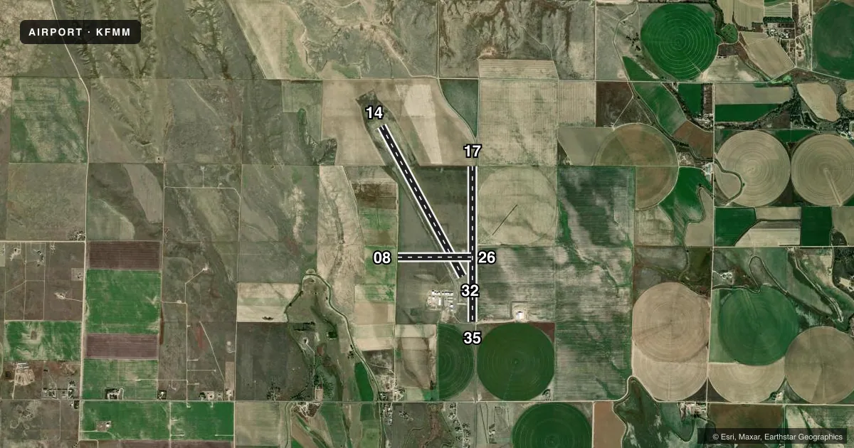
Runways & pattern
Full pagePattern entry · RWY 32
LEFT TRAFFIC| Runway | Heading (°M) | Length | Surface | Traffic |
|---|---|---|---|---|
| 14/32Favored | 143° / 323° | 5,731 ft | ASPH | Standard L |
| 17/35 | 172° / 352° | 5,216 ft | TURF-DIRT | Standard L |
| 08/26 | 82° / 262° | 2,468 ft | TURF | Standard L |
Runway end performance
| End | TORA | TODA | ASDA | LDA | VGSI | Approach lights | Obstruction |
|---|---|---|---|---|---|---|---|
| 14 | — | — | — | — | PAPI 2-box left(3°) | — | — |
| 32 | — | — | — | — | PAPI 2-box left(3°) | — | 17', road, 393' from thr, 298' R of cntrln, slope 11 |
| 35 | — | — | — | — | — | — | 10', road, 9' from thr, 0' R of cntrln, slope 0 |
| 08 | — | — | — | — | — | — | 10', other, 10' from thr, 0' R of cntrln, slope 0 |
| 26 | — | — | — | — | — | — | 18', road, 151' from thr, 0' R of cntrln, slope 8 |
Declared distances in feet. TORA = takeoff run available, TODA = takeoff distance, ASDA = accelerate-stop, LDA = landing distance.
Airport sketch
Runways drawn to scale from FAA survey coordinates, rendered over satellite imagery. Not for navigation.
Approaches & charts
Services on the field
Fuel grades, oxygen, maintenance, ramp storage and lighting — as declared to the FAA by the airport operator.
Fuel & services
- Fuel
- 100LLA1
- Oxygen (bottled)
- Not available
- Oxygen (bulk)
- Not available
- Airframe repair
- Not available
- Power plant repair
- Not available
- Other services
- AGRI,AMB,CHTR,INSTR,PAJA
Ramp & ground
- Transient storage
- Tie-down
- Hangar
- Landing fee
- No fee published
- Customs
- Not available
- Lighting schedule
- SEE RMK
- Beacon schedule
- SS-SR
- Beacon
- White / Green (civil land)(WG)
- Wind indicator
- Lighted
- Segmented circle
- Yes
Fuel & FBOs
Cheapest 100LL and Jet A on the field and nearby. Always confirm with the FBO before taxi.
Airport notes
Surface conditions, obstructions, local procedures, lighting outages and other notes published with each FAA cycle.
General notes
- RWY 17/35, 21 ROAD 100 FT E OF AND PARALLEL TO RWY CNTRLN FULL LENGTH.
- BE ALERT, INTENSIVE USAF STUDENT TRNG INVOF COLORADO SPRINGS & PUEBLO COLORADO.
- FOR CD CTC DENVER ARTCC AT 303-651-4257.
Lighting notes
- ACTVT REIL RWY 14 & 32; MIRL RWY 14/32 - CTAF.
Fuel notes
- 100LLFUEL AVAILABLE 24/7 WITH CREDIT CARD.
Approach & departure obstructions
- 08INTERMITTENTLY HAS 5 FT HAY BALES 10 FT FROM AND PARALLEL TO THRESHOLD.
VFR map & nearby airports
VFR sectional. Tap any ICAO chip to open that airport.
Key facts · KFMM
Answer card- ICAO
- KFMM
- Name
- FORT MORGAN MUNI
- Location
- FORT MORGAN, COLORADO
- Elevation
- 4,595.3 ft MSL
- Traffic pattern altitude
- 5,626.3 ft MSL (1,031 AGL)
- Control tower
- Non-towered (use CTAF)
- Total runways
- 3
- Longest runway
- 14/32 · 5,731 ft
- Published ILS approaches
- 0
- Published frequencies
- 2
- Magnetic variation
- 8°
- Current flight rules
- VFR
- Current wind
- 330° at 13 kt
- Favored runway now
- RWY 32
Fort Morgan Muni sits in Fort Morgan, Colorado. The field elevation is 4,595.3 ft MSL. It has three runways. The longest is runway 14/32 at 5,731 ft. There is no control tower. CTAF and UNICOM are both 123.05.
No ILS approaches are published here. Pattern altitude is 1,031 ft AGL, which is 5,626.3 ft MSL. Runway 14 and 32 have runway end identifier lights. Runway 14/32 also has medium intensity runway lighting on CTAF. For fuel, Hi-Plains Aviation is on the field. It carries 100LL and Jet A. Fuel is available 24 hours a day with credit card.
A few operational items matter here. Runway 17/35 has 21 Road about 100 feet east of and parallel to the centerline for the full length. Runway 08 can have hay bales near the threshold. Clearance delivery is handled through Denver ARTCC. Also watch for intensive U.S. Air Force student training in the Colorado Springs and Pueblo area. If you are planning a night arrival or a first visit, verify the current Chart Supplement and brief the lighting setup before you go.