METAR & TAF KGXY
Current METAR
Observed 10:56Z
KGXY 271056Z AUTO 02007KT 10SM CLR 27/12 A3007 RMK AO2 SLP118 T02670122
- Wind
- 020° @ 7 kt
- Visibility
- 10 SM
- Temp / Dew
- 27°C / 12°C
- Altimeter
- 30.07 inHg
- Clouds
- CLR
- Density alt
- 7,078 ft
- Ceiling
- Unlimited
- Rules
- VFR
Airport info & contacts
Manager on record, flight service, ARTCC, attendance schedule and pattern altitude — published by the FAA and refreshed every 28 days.
Location
- From city
- 3 NM E
- VFR sectional
- CHEYENNE
- Pattern altitude
- 800 ft AGL · 5,497 ft MSL
- ARTCC
- ZDV · DENVER
- NOTAM facility
- GXY (NOTAM-D)
Airport manager
- Name
- COOPER ANDERSON
- Phone
- 970-336-3000
- Address
- PO BOX 727, GREELEY CO 80632
Flight service · Hours
- FSS DEN
- DENVER1-800-WX-BRIEF
- Attendance
- 0600-2000
Frequencies
Tap any row to copy the frequency to your clipboard.
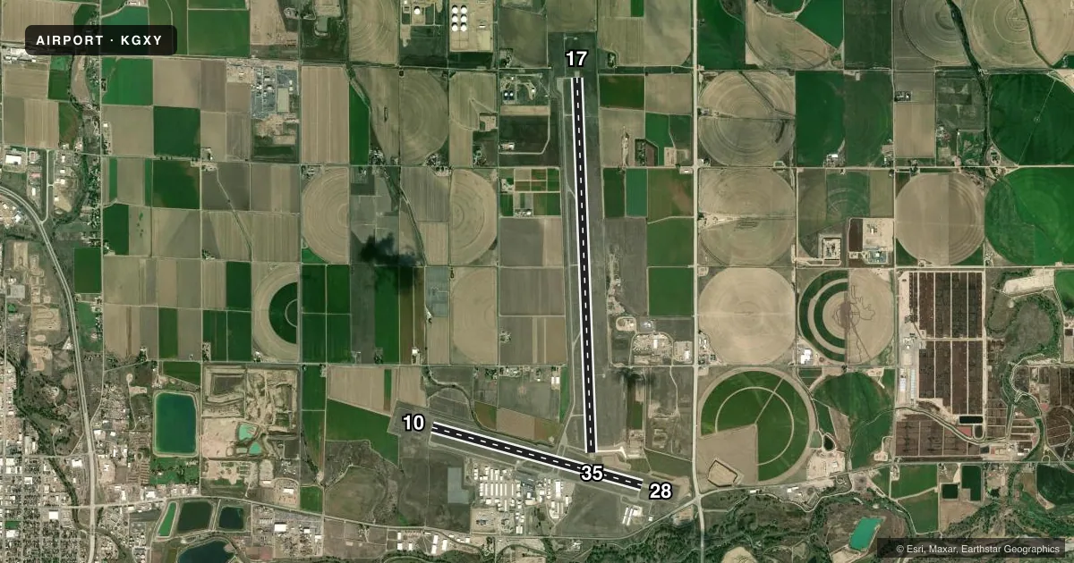
Runways & pattern
Full pagePattern entry · RWY 35
LEFT TRAFFIC| Runway | Heading (°M) | Length | Surface | Traffic |
|---|---|---|---|---|
| 17/35Favored | 169° / 349° | 10,000 ft | ASPH | Standard L |
| 10/28 | 97° / 277° | 5,801 ft | ASPH | 28 R |
Runway end performance
| End | TORA | TODA | ASDA | LDA | VGSI | Approach lights | Obstruction |
|---|---|---|---|---|---|---|---|
| 17 | — | — | — | — | PAPI 2-box left(3°) | — | — |
| 35 | — | — | — | — | PAPI 2-box left(3°) | — | — |
| 10 | — | — | — | — | PAPI 2-box left(3°) | — | — |
| 28 | — | — | — | — | VASI 4-box left(3°) | — | — |
Declared distances in feet. TORA = takeoff run available, TODA = takeoff distance, ASDA = accelerate-stop, LDA = landing distance.
Airport sketch
Runways drawn to scale from FAA survey coordinates, rendered over satellite imagery. Not for navigation.
Approaches & charts
ILS · 1
Services on the field
Fuel grades, oxygen, maintenance, ramp storage and lighting — as declared to the FAA by the airport operator.
Fuel & services
- Fuel
- 100LLA
- Oxygen (bottled)
- HIGH/LOW
- Airframe repair
- Major
- Power plant repair
- Major
- Other services
- AGRI,AMB,AVNCS,CHTR,INSTR,RNTL,SURV
Ramp & ground
- Transient storage
- Tie-down
- Hangar
- Landing fee
- No fee published
- Customs
- Not available
- Lighting schedule
- SEE RMK
- Beacon schedule
- SS-SR
- Beacon
- White / Green (civil land)(WG)
- Wind indicator
- Lighted
- Segmented circle
- Yes
Fuel & FBOs
Cheapest 100LL and Jet A on the field and nearby. Always confirm with the FBO before taxi.
Airport notes
Surface conditions, obstructions, local procedures, lighting outages and other notes published with each FAA cycle.
General notes
- RWY 17/35 PREFERRED USE WHEN X WIND COMPONENT EXCEEDS 12 KT ON RWY 10/28.
- RWY 35 PREFERRED USE WHEN WIND LESS THAN 5 KNOTS. RWY 35 PREFERRED FOR TGL.
- WILDLIFE & BIRDS ON & INVOF APRT.
- OIL DRILLING RIGS UP TO 120 FT ON AND INVOF ARPT.
- ACFT DEPG RWY 28 AVOID SB TURN PR TO XNG RWY 10 THLD.
- CTN EXTENDED TAXI DIST TO RWY 17/35 VIA TWY C1
- TWO HEL PRKG PSN (TDPC MKD) LOCATED ON WEST EDGE OF MAIN APN; NO DESIGNATED HELIPADS.
- TXY PAVEMENT STRENGTH IS LESS THAN PUBLISHED RWY PCR; TWYS CONSIST OF OLDER PAVEMENT AND HAVE NOT BEEN EVALUATED.
- CTN INTENSIVE USAF STUDENT T INVOF COLORADO SPRINGS AND PUEBLO, COLORADO
Lighting notes
- ACTVT MIRL RWYS 10/28 & 17/35, & REIL RWYS 10, 28, 17, & 35 - CTAF. PAPI RWYS 10, 17, 35, & VASI RWY 28 OPR 24 HRS.
Runway surface & condition
- 10/28PCR VALUE: 190/F/D/X/T
- 17/35PCR VALUE: 160/F/C/X/T
Approach & departure obstructions
- 1010 FT DIRT ACES ROAD AT THLD & PARL TO EXTDD CNTRLN; 9 FT CROPS 140 FT FM THLD 90 FT LEFT & RIGHT OF CNTRLN.
Other notes
- THIS AIRPORT HAS BEEN SURVEYED BY THE NATIONAL GEODETIC SURVEY.
- 1PREARRANGE AFT HRS ARPT ACCESS WITH FBOS. CALL 970-336-3000 OR 970-336-3010.
- 1FOR ATTENDANCE AFT HRS CALL 970-336-3010 AND FOLLOW PROMPTS.
VFR map & nearby airports
VFR sectional. Tap any ICAO chip to open that airport.
Key facts · KGXY
Answer card- ICAO
- KGXY
- Name
- GREELEY-WELD COUNTY
- Location
- GREELEY, COLORADO
- Elevation
- 4,696.8 ft MSL
- Traffic pattern altitude
- 5,496.8 ft MSL (800 AGL)
- Control tower
- Non-towered (use CTAF)
- Total runways
- 2
- Longest runway
- 17/35 · 10,000 ft
- Published ILS approaches
- 1
- Published frequencies
- 5
- Magnetic variation
- 8°
- Current flight rules
- VFR
- Current wind
- 020° at 7 kt
- Favored runway now
- RWY 35
Greeley-Weld County Airport sits in Greeley, Colorado at 4,696.8 ft MSL. It has two asphalt runways. The longest is 10,000 ft. The other is 5,801 ft. There is no control tower, so expect CTAF traffic flow and self-announced position calls on 122.7.
The published pattern altitude is 800 ft AGL, which puts the traffic pattern at 5,496.8 ft MSL. One ILS is published for runway 35. Peak Flight Support is on the field. It carries AVGAS 100LL and Jet A. Call ahead if you need after-hours access or attendance.
This is a busy high-plains field with some operational details worth planning for. Runway 17/35 is the preferred runway when the crosswind on 10/28 gets above 12 knots. Runway 35 is also preferred when wind is less than 5 knots. It is the preferred runway for touch-and-go work too. Watch for oil drilling rigs up to 120 ft near the airport. Wildlife and birds are also reported in and around the field. If you depart runway 28, avoid a southbound turn before crossing the runway 10 threshold. The lighting is pilot-controlled on CTAF. It has medium intensity lights and runway end identifier lights on both runways.