METAR & TAF KBDU
Current METAR
Observed 11:35Z
KBDU 271135Z AUTO 00000KT 10SM CLR 26/08 A3013 RMK AO2
- Wind
- 000° @ 0 kt
- Visibility
- 10 SM
- Temp / Dew
- 26°C / 8°C
- Altimeter
- 30.13 inHg
- Clouds
- CLR
- Density alt
- 7,617 ft
- Ceiling
- Unlimited
- Rules
- VFR
Airport info & contacts
Manager on record, flight service, ARTCC, attendance schedule and pattern altitude — published by the FAA and refreshed every 28 days.
Location
- From city
- 3 NM NE
- VFR sectional
- CHEYENNE
- Pattern altitude
- 1,012 ft AGL · 6,300 ft MSL
- ARTCC
- ZDV · DENVER
- NOTAM facility
- DEN (NOTAM-D)
Airport manager
- Name
- ERIC VENCES
- Phone
- 303-441-3108
- Address
- 3327 AIRPORT ROAD, BOULDER CO 80301
Flight service · Hours
- FSS DEN
- DENVER1-800-WX-BRIEF
- Attendance
- 0800-1700
Frequencies
Tap any row to copy the frequency to your clipboard.
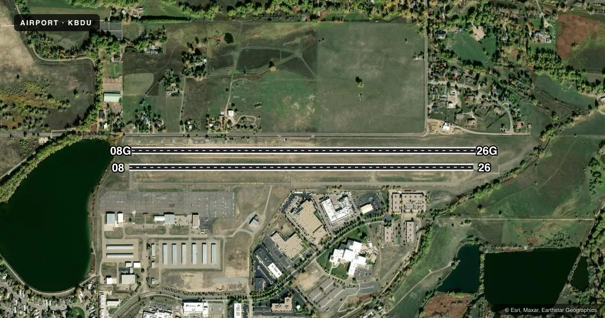
Runways & pattern
Full pagePattern entry · RWY 08
LEFT TRAFFIC| Runway | Heading (°M) | Length | Surface | Traffic |
|---|---|---|---|---|
| 08/26 | 78° / 258° | 4,100 ft | ASPH | 26 R |
| 08G/26G | 78° / 258° | 4,100 ft | ASPH-TURF | 26G R |
Runway end performance
| End | TORA | TODA | ASDA | LDA | VGSI | Approach lights | Obstruction |
|---|---|---|---|---|---|---|---|
| 08 | 4,100' | 4,100' | 4,100' | 3,900' | — | — | 10', trees, 278' from thr, 44' R of cntrln, slope 7 |
| 26 | 4,100' | 4,100' | 3,900' | 3,900' | PAPI 4-box left(3.5°) | — | — |
| 08G | — | — | — | — | — | — | 56', trees, 806' from thr, 153' R of cntrln, slope 14 |
Declared distances in feet. TORA = takeoff run available, TODA = takeoff distance, ASDA = accelerate-stop, LDA = landing distance.
Airport sketch
Runways drawn to scale from FAA survey coordinates, rendered over satellite imagery. Not for navigation.
Approaches & charts
Services on the field
Fuel grades, oxygen, maintenance, ramp storage and lighting — as declared to the FAA by the airport operator.
Fuel & services
- Fuel
- 100LLA
- Airframe repair
- Major
- Power plant repair
- Major
- Other services
- GLD,INSTR,PAJA,RNTL,SALES,TOW
Ramp & ground
- Transient storage
- Tie-down
- Hangar
- Landing fee
- No fee published
- Customs
- Not available
- Lighting schedule
- SEE RMK
- Beacon schedule
- SS-SR
- Beacon
- White / Green (civil land)(WG)
- Wind indicator
- Lighted
- Segmented circle
- Yes
Fuel & FBOs
Cheapest 100LL and Jet A on the field and nearby. Always confirm with the FBO before taxi.
Airport notes
Surface conditions, obstructions, local procedures, lighting outages and other notes published with each FAA cycle.
General notes
- 25 - 55 FT TREES OUTLINE HAYDEN LAKE 200 FT FM RWY 08G THR; HAYDEN LAKE 250 FT FM RWY 8 & 8G THR.
- NOISE ABATEMENT PROC IN EFCT - AMGR OR HTTP:/WWW.BOULDERCOLORADO.GOV/AIRPORT.
- PAJA & WATER FOWL ON & INVOF ARPT.
- TPA: RWY 08/26 TPA 1012 FT AGL.
- SIMUL APCH & DEP FM RWY 8/26 & 8G/26G NA; PWRD ACFT YIELD TO GLIDERS ON FNA OR INITIATE GO-AROUND FOR ADEQUATE SPACING.
- MIDFIELD PAT ENTRY FM S GLIDER USE ONLY.
- FOR CD CTC DENVER APCH AT 303-342-1916.
- GLIDER ACT DLY SR-SS SE OF ARPT BTN ARPT & POWER PLANT FM 6300 - 9000 FT; RCMD AVOIDANCE & EXERCIZE EXTREME CTN WHEN TRANSITING AREA.
- SIMUL RWY OPS ON RWY 8/26 AND 8G/26G ARE PROHIBITED.
Lighting notes
- ACTVT PAPI RWY 26; MIRL RWY 8/26 - CTAF.
Fuel notes
- 100LL100LL SELF SERVE AVBL H24.
Runway surface & condition
- 08/26GLIDER OPS 60 FT PARL TO RWY.
- 08G/26GLNDG AREA UNDEFINED; GLIDER OPS ONLY; 197 FT SEPN CNTRLN TO CNTRLN.
- 08G/26G3000 FT X 20 FT CHIP & SEAL W END; 1100 FT GRASS E END.
Approach & departure obstructions
- 08DEP TURN BLW 512 FT NA. 40-60 FT TREES RESULT IN 27 DEG OBST CLNC SLOPE TO DTHR. RWY 08 CALM WIND RWY.
- 26DURG W WIND EXP SVR TURB. 300 FT SAFETY AREA OUTLINED WITH RED REFLECTORS; 130 FT DROPOFF E OF MKD AREA.
- 08RWY 08 10 FT TREE, DIST 277 FT, 14 FT R, APCH SLP 47:1 DSPLCD THLD.
VFR map & nearby airports
VFR sectional. Tap any ICAO chip to open that airport.
Key facts · KBDU
Answer card- ICAO
- KBDU
- Name
- BOULDER MUNI
- Location
- BOULDER, COLORADO
- Elevation
- 5,288 ft MSL
- Traffic pattern altitude
- 6,300 ft MSL (1,012 AGL)
- Control tower
- Non-towered (use CTAF)
- Total runways
- 2
- Longest runway
- 08/26 · 4,100 ft
- Published ILS approaches
- 0
- Published frequencies
- 2
- Magnetic variation
- 12°
- Current flight rules
- VFR
- Current wind
- 000° at 0 kt
- Favored runway now
- –
Boulder Muni sits in Boulder, Colorado at 5,288 ft MSL. It has two runways. Both are 4,100 ft long. The airport is non-towered. CTAF and UNICOM are both 122.725. No ILS approaches are published. Pattern altitude for runways 08/26 is 6,300 ft MSL, which is 1,012 ft AGL.
Journeys Aviation is on the field. It carries 100LL and Jet A Prist. 100LL self-serve fuel is available 24 hours a day. That helps on late arrivals. The runway lighting and the PAPI on runway 26 are activated by CTAF.
This is a high-elevation field, so performance planning matters. The published remarks also call out noise abatement procedures. Check the current FAA Chart Supplement before you go. Glider activity is a real factor here. Powered aircraft must yield to gliders on final or go around for spacing. Midfield pattern entry from the south is for glider use only. Runway 08 has a displaced threshold. There is a tree near the approach. Departure turns below 512 ft are not authorized. Runway 26 can see severe turbulence in west wind exposure. Use the published pattern and keep a close eye out for gliders and terrain near the field.