METAR & TAF KEIK
Current METAR
Observed 17:15Z
KEIK 271715Z AUTO 01004KT 9SM OVC130 28/13 A3015 RMK AO2 T02850128 $
- Wind
- 010° @ 4 kt
- Visibility
- 9 SM
- Temp / Dew
- 28°C / 13°C
- Altimeter
- 30.15 inHg
- Clouds
- OVC
- Density alt
- 7,623 ft
- Ceiling
- 13,000 ft AGL
- Rules
- VFR
Airport info & contacts
Manager on record, flight service, ARTCC, attendance schedule and pattern altitude — published by the FAA and refreshed every 28 days.
Location
- From city
- 3 NM S
- VFR sectional
- CHEYENNE
- ARTCC
- ZDV · DENVER
- NOTAM facility
- DEN (NOTAM-D)
Airport manager
- Name
- JASON HURD
- Phone
- 303-664-0633
- Address
- 395 AIRPORT DRIVE, ERIE CO 80516
Flight service · Hours
- FSS DEN
- DENVER1-800-WX-BRIEF
- Attendance
- MON-SAT · 0800-1700
- SUN · 0800-1400
Frequencies
Tap any row to copy the frequency to your clipboard.
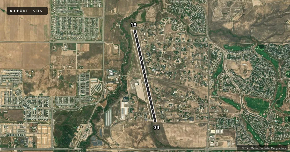
Runways & pattern
Full pagePattern entry · RWY 34
LEFT TRAFFICRunway end performance
| End | TORA | TODA | ASDA | LDA | VGSI | Approach lights | Obstruction |
|---|---|---|---|---|---|---|---|
| 16 | — | — | — | — | PAPI 2-box left(3°) | — | — |
| 34 | — | — | — | — | PAPI 2-box left(3°) | — | 78', tree, 1522' from thr, 422' R of cntrln, slope 16 |
Declared distances in feet. TORA = takeoff run available, TODA = takeoff distance, ASDA = accelerate-stop, LDA = landing distance.
Airport sketch
Runways drawn to scale from FAA survey coordinates, rendered over satellite imagery. Not for navigation.
Approaches & charts
Services on the field
Fuel grades, oxygen, maintenance, ramp storage and lighting — as declared to the FAA by the airport operator.
Fuel & services
- Fuel
- 100LLA
- Oxygen (bottled)
- HIGH/LOW
- Airframe repair
- Major
- Power plant repair
- Major
- Other services
- INSTR,RNTL,SALES
Ramp & ground
- Transient storage
- Tie-down
- Hangar
- Landing fee
- No fee published
- Customs
- Not available
- Lighting schedule
- SEE RMK
- Beacon schedule
- SS-SR
- Beacon
- White / Green (civil land)(WG)
- Wind indicator
- Lighted
- Segmented circle
- Yes
Fuel & FBOs
Cheapest 100LL and Jet A on the field and nearby. Always confirm with the FBO before taxi.
Airport notes
Surface conditions, obstructions, local procedures, lighting outages and other notes published with each FAA cycle.
General notes
- AFT HR EMERG - 303-870-5659.
- TWY A LGTD.
- FOR CD CTC DENVER APCH AT 303-342-1916.
Lighting notes
- ACTVT REIL RWY 16; PAPI RWY 16 & 34; MIRL RWY 16/34 - CTAF.
Fuel notes
- 100LLSELF SVC AVBL H24 WITH CREDIT CARD.
Runway surface & condition
- 16/34-2 FT TRRN 60 - 70 FT E OF CNTRLN FULL LEN.
Approach & departure obstructions
- 16-2 TO -6 FT DITCH WI 700 FT OF RWY END VARIOUS LOCATIONS.
- 3430 FT ROAD 1350 FT FM THR BOTH SIDES; -6 TO -12 FT DITCH 60 FT L OF CNTRLN PARL TO FIRST 750 FT OF RWY.
Other notes
- PROVIDED TELEPHONE WIRES NORTH & EAST OF FACILITY ARE EITHER MARKED OR BURIED.
VFR map & nearby airports
VFR sectional. Tap any ICAO chip to open that airport.
Key facts · KEIK
Answer card- ICAO
- KEIK
- Name
- ERIE MUNI
- Location
- ERIE, COLORADO
- Elevation
- 5,119.4 ft MSL
- Traffic pattern altitude
- 6,119.4 ft MSL (1,000 AGL)
- Control tower
- Non-towered (use CTAF)
- Total runways
- 1
- Longest runway
- 16/34 · 4,700 ft
- Published ILS approaches
- 0
- Published frequencies
- 4
- Magnetic variation
- 8°
- Current flight rules
- VFR
- Current wind
- 010° at 4 kt
- Favored runway now
- RWY 34
Erie Muni (KEIK) sits in Erie, Colorado at 5,119.4 ft MSL. It has one runway, 16/34, which is 4,700 ft long and paved with concrete. The field is not towered. CTAF and UNICOM are both 123.0. Denver Approach handles clearance delivery. The published pattern altitude is not given, so use the standard 1,000 ft AGL for light piston operations unless the current Chart Supplement says otherwise.
There are no ILS approaches published here. Runway 16 and Runway 34 both have PAPI. Runway 16 also has runway end identifier lights. Taxiway A is lighted. Self-serve 100LL is available 24 hours with a credit card. Vector Air is on the field. It carries AVGAS 100LL and Jet A. Their phone is (303) 664-0633.
For a first-time arrival, pay attention to the elevation. Performance will be different than at a low field. The published remarks also call out terrain and obstacles near both runway ends. There is a ditch near Runway 16. There is a road and another ditch near Runway 34. Telephone wires north and east of the airport are marked or buried. Check the current Chart Supplement before you go for any updated remarks or operational changes.