METAR & TAF KLMO
Current METAR
Observed 13:15Z
KLMO 271315Z AUTO 33004KT 10SM SCT041 SCT050 BKN120 24/14 A3017 RMK AO2 T02360138
- Wind
- 330° @ 4 kt
- Visibility
- 10 SM
- Temp / Dew
- 24°C / 14°C
- Altimeter
- 30.17 inHg
- Clouds
- BKN
- Density alt
- 7,039 ft
- Ceiling
- 12,000 ft AGL
- Rules
- VFR
Airport info & contacts
Manager on record, flight service, ARTCC, attendance schedule and pattern altitude — published by the FAA and refreshed every 28 days.
Location
- From city
- 3 NM SW
- VFR sectional
- CHEYENNE
- ARTCC
- ZDV · DENVER
- NOTAM facility
- DEN (NOTAM-D)
Airport manager
- Name
- LEVI BROWN
- Phone
- 303-651-8431
- Address
- 229 AIRPORT ROAD, LONGMONT CO 80503
Flight service · Hours
- FSS DEN
- DENVER1-800-WX-BRIEF
- Attendance
- DALGT
Frequencies
Tap any row to copy the frequency to your clipboard.
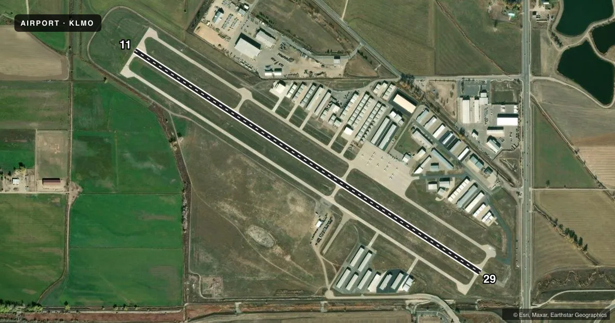
Runways & pattern
Full pagePattern entry · RWY 29
LEFT TRAFFICRunway end performance
| End | TORA | TODA | ASDA | LDA | VGSI | Approach lights | Obstruction |
|---|---|---|---|---|---|---|---|
| 11 | — | — | — | — | VASI 2-box left(3°) | — | 36', tree, 826' from thr, 68' R of cntrln, slope 17 |
| 29 | — | — | — | — | VASI 2-box left(3°) | — | 8', road, 436' from thr, 0' R of cntrln, slope 29 |
Declared distances in feet. TORA = takeoff run available, TODA = takeoff distance, ASDA = accelerate-stop, LDA = landing distance.
Airport sketch
Runways drawn to scale from FAA survey coordinates, rendered over satellite imagery. Not for navigation.
Approaches & charts
Services on the field
Fuel grades, oxygen, maintenance, ramp storage and lighting — as declared to the FAA by the airport operator.
Fuel & services
- Fuel
- 100LLAMOGAS
- Oxygen (bottled)
- Not available
- Oxygen (bulk)
- Not available
- Airframe repair
- Major
- Power plant repair
- Major
- Other services
- CHTR,INSTR,PAJA,RNTL,SALES
Ramp & ground
- Transient storage
- Tie-down
- Landing fee
- No fee published
- Customs
- Not available
- Lighting schedule
- SEE RMK
- Beacon schedule
- SS-SR
- Beacon
- White / Green (civil land)(WG)
- Wind indicator
- Lighted
- Segmented circle
- Yes
Fuel & FBOs
Cheapest 100LL and Jet A on the field and nearby. Always confirm with the FBO before taxi.
Airport notes
Surface conditions, obstructions, local procedures, lighting outages and other notes published with each FAA cycle.
General notes
- ULTRALIGHT & HELICOPTER ACTIVITY ON & INVOF ARPT.
- RY 11 HAS -7 FT DITCH 420 FT AND 900 FT FM THLD ON EXTDD THLD.
- RY 29 HAS +15 FT HWY 702 FT FM THLD; +25 TO 35 FT BLDGS/TANKS APROXLY 1300 FT L OF THLD.
- NOISE ABATEMENT PROCEDURES IN EFFECT CTC ARPT MANAGER 303-651-8431.
- PARAJUMPING ON AND IN VICINITY OF ARPT PRIMARILY S OF RY, AVOID OVERFLIGHTS MID FIELD.
- FOR CD CTC DENVER APCH AT 303-342-1916.
Lighting notes
- ACTVT MIRL RY 11/29 AND VASI RY 11/29 - CTAF.
Approach & departure obstructions
- 11VASI UNUSLB BYD 3.9 NM. VASI DOES NOT PRVD OBST CLNC BYD 3.9 NM FROM THLD.
VFR map & nearby airports
VFR sectional. Tap any ICAO chip to open that airport.
Key facts · KLMO
Answer card- ICAO
- KLMO
- Name
- VANCE BRAND
- Location
- LONGMONT, COLORADO
- Elevation
- 5,055.3 ft MSL
- Traffic pattern altitude
- 6,055.3 ft MSL (1,000 AGL)
- Control tower
- Non-towered (use CTAF)
- Total runways
- 1
- Longest runway
- 11/29 · 4,799 ft
- Published ILS approaches
- 0
- Published frequencies
- 4
- Magnetic variation
- 10°
- Current flight rules
- VFR
- Current wind
- 330° at 4 kt
- Favored runway now
- RWY 29
Vance Brand Airport (KLMO) sits in Longmont, Colorado. Field elevation is 5,055.3 ft MSL. The airport has one runway, 11/29, which is 4,799 ft long. There is no control tower. No ILS approaches are published here. Pattern altitude is not published, so use the standard 1,000 ft AGL for light piston traffic unless the current Chart Supplement says otherwise.
Fly Elite Aviation is on the field. It carries 100LL, Jet A and mogas. If you need current ramp or service details, call them directly at (303) 774-8081. Published remarks matter here. Runway 11 has a ditch on the extended centerline. It sits 420 ft and 900 ft from the threshold. Runway 29 has a highway close in on short final. There are also buildings and tanks left of the 29 threshold. Parajumping occurs on and near the airport, mainly south of the runway. Avoid midfield overflights. Medium intensity runway lights and the VASI on 11/29 are CTAF-activated. Noise abatement procedures are in effect. Check with the airport manager before arrival if you need the current guidance.
This is a high-elevation field at the edge of the Front Range. Expect density altitude to matter on warm days. Use the current Chart Supplement for any updated procedures. Denver Approach handles clearance delivery at the published number.