METAR & TAF 11V
11V does not publish a METAR.
Showing the nearest reporting station: KGXY (GREELEY-WELD COUNTY) · 6.7 NM away. Conditions at 11V may differ.
METAR · KGXY
Observed 10:56Z
KGXY 271056Z AUTO 02007KT 10SM CLR 27/12 A3007 RMK AO2 SLP118 T02670122
- Wind
- 020° @ 7 kt
- Visibility
- 10 SM
- Temp / Dew
- 27°C / 12°C
- Altimeter
- 30.07 inHg
- Clouds
- CLR
- Density alt
- 7,231 ft
- Ceiling
- Unlimited
- Rules
- VFR
Airport info & contacts
Manager on record, flight service, ARTCC, attendance schedule and pattern altitude — published by the FAA and refreshed every 28 days.
Location
- From city
- 7 NM SE
- VFR sectional
- CHEYENNE
- ARTCC
- ZDV · DENVER
- NOTAM facility
- DEN (NOTAM-D)
Airport manager
- Name
- ROBERT EASTON
- Phone
- 970-302-3336
- Address
- PO BOX 309, LA SALLE CO 80645
Flight service · Hours
- FSS DEN
- DENVER1-800-WX-BRIEF
- Attendance
- DALGT
Frequencies
Tap any row to copy the frequency to your clipboard.
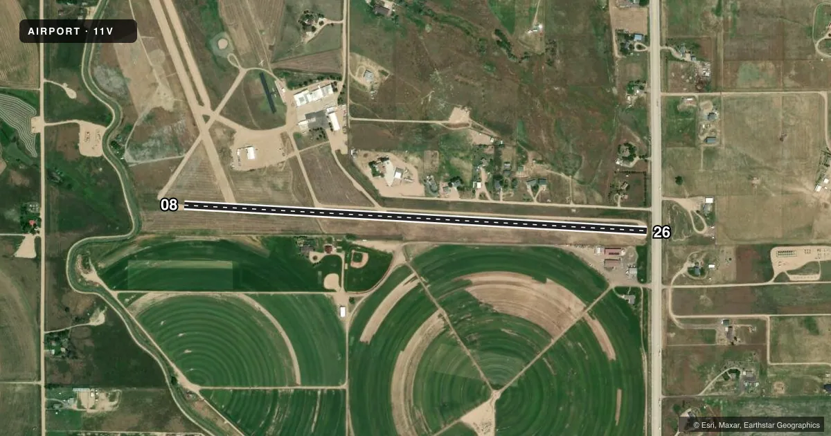
Runways & pattern
Full pagePattern entry · RWY 08
LEFT TRAFFICRunway end performance
| End | TORA | TODA | ASDA | LDA | VGSI | Approach lights | Obstruction |
|---|---|---|---|---|---|---|---|
| 26 | — | — | — | — | — | — | 15', road, 43' from thr, 0' R of cntrln, slope 2 |
Declared distances in feet. TORA = takeoff run available, TODA = takeoff distance, ASDA = accelerate-stop, LDA = landing distance.
Airport sketch
Runways drawn to scale from FAA survey coordinates, rendered over satellite imagery. Not for navigation.
Approaches & charts
Services on the field
Fuel grades, oxygen, maintenance, ramp storage and lighting — as declared to the FAA by the airport operator.
Fuel & services
- Fuel
- Not available
- Oxygen (bottled)
- Not available
- Oxygen (bulk)
- Not available
- Airframe repair
- Not available
- Power plant repair
- Not available
- Other services
- AGRI,INSTR
Ramp & ground
- Transient storage
- Tie-down
- Hangar
- Landing fee
- No fee published
- Wind indicator
- Yes
- Segmented circle
- No
Fuel & FBOs
Cheapest 100LL and Jet A on the field and nearby. Always confirm with the FBO before taxi.
Airport notes
Surface conditions, obstructions, local procedures, lighting outages and other notes published with each FAA cycle.
General notes
- UNL VEHICULAR ACCESS TO RYS & TWYS.
- OPNS ARE PRIMARILY AGRI OPNS.
- +2 FT CABLE 20 FT E OF RY 08/26 CROSSING CNTRLN.
- RYS 08/26 & 14/32 ALL SURFACES SOFT WHEN WET.
- RY 14/32, HAS 4 FT FENCE 75 FT W OF RY CNTRLN FULL LENGTH.
- RY 14/32, HAS -5 FT DITCH ADJACENT TO BOTH EDGES FULL LENGTH.
- RC ACFT INVOF ARPT.
- RWY 32, 4 FT FENCE 280 FT FROM THRESHOLD L/R OF CNTRLN.
- RWY 14 HAS IRRIGATION DITCH 50 FT FROM THLD L/R OF CNTRLN.
- FOR CD CTC DENVER APCH AT 303-342-1916.
- DGNL SFC THAT BGNS AT RY 8 APCH AND INTERSECTS RY 14/32 IS NOT A PUB USE RY AND SHOULD NOT BE USED FOR TAKEOFFS AND LDGS.
Approach & departure obstructions
- 14LRG ROTG SPRINKLER SYS LOCATED OFF ARPT PROPERTY ON ADJ TURF FARM.
VFR map & nearby airports
VFR sectional. Tap any ICAO chip to open that airport.
Key facts · 11V
Answer card- ICAO
- 11V
- Name
- EASTON/VALLEY VIEW
- Location
- GREELEY, COLORADO
- Elevation
- 4,820 ft MSL
- Traffic pattern altitude
- 5,820 ft MSL (1,000 AGL)
- Control tower
- Non-towered (use CTAF)
- Total runways
- 1
- Longest runway
- 08/26 · 4,000 ft
- Published ILS approaches
- 0
- Published frequencies
- 1
- Magnetic variation
- 11°
- Current flight rules
- VFR
- Current wind
- 020° at 7 kt
- Favored runway now
- RWY 08
Easton/Valley View Airport (11V) sits in Greeley, Colorado at 4,820 ft MSL. It has one runway, 08/26, which is 4,000 ft long on turf-dirt. The field is not towered. CTAF is 122.9. No ILS approaches are published here.
Pattern altitude is not published. Use the standard 1,000 ft AGL pattern unless local procedures or current Chart Supplement remarks say otherwise. The airport is used primarily for agricultural operations. That matters here. Expect low-level traffic and field activity. Expect radio controlled aircraft in the vicinity. Runway surfaces are soft when wet. The published remarks also call out a cable east of runway 08/26, a sprinkler system off airport property near the field and unlimited vehicular access to runways and taxiways. Treat this as a working rural strip, not a clean paved airport.
No on-field FBOs are listed. Check with the airport operator or the FBO directly by phone before arrival if you need current services. For clearance delivery, Denver Approach is listed in the remarks. If you are planning a first trip in, review the current Chart Supplement for any local restrictions and pay close attention to the runway environment before you commit on final.