METAR & TAF 17V
17V does not publish a METAR.
Showing the nearest reporting station: KHEQ (HOLYOKE) · 15.6 NM away. Conditions at 17V may differ.
METAR · KHEQ
Observed 14:55Z
KHEQ 271455Z AUTO 03008KT 10SM CLR 30/19 A2998 RMK AO2 T02960188 53012
- Wind
- 030° @ 8 kt
- Visibility
- 10 SM
- Temp / Dew
- 30°C / 19°C
- Altimeter
- 29.98 inHg
- Clouds
- CLR
- Density alt
- 6,729 ft
- Ceiling
- Unlimited
- Rules
- VFR
Airport info & contacts
Manager on record, flight service, ARTCC, attendance schedule and pattern altitude — published by the FAA and refreshed every 28 days.
Location
- From city
- 2 NM SE
- VFR sectional
- CHEYENNE
- ARTCC
- ZDV · DENVER
- NOTAM facility
- DEN (NOTAM-D)
Airport manager
- Name
- RON CARPENTER
- Phone
- 970-854-2735
- Address
- TOWN HALL BOX 205, HAXTUN CO 80731
Flight service · Hours
- FSS DEN
- DENVER1-800-WX-BRIEF
- Attendance
- Unattended
Frequencies
Tap any row to copy the frequency to your clipboard.
Runways & pattern
Full pagePattern entry · RWY 35
LEFT TRAFFICRunway end performance
| End | TORA | TODA | ASDA | LDA | VGSI | Approach lights | Obstruction |
|---|---|---|---|---|---|---|---|
| 17 | — | — | — | — | — | — | 21', road, 2' from thr, 41' R of cntrln, slope 0 |
| 35 | — | — | — | — | — | — | 15', road, 2' from thr, 39' R of cntrln, slope 0 |
Declared distances in feet. TORA = takeoff run available, TODA = takeoff distance, ASDA = accelerate-stop, LDA = landing distance.
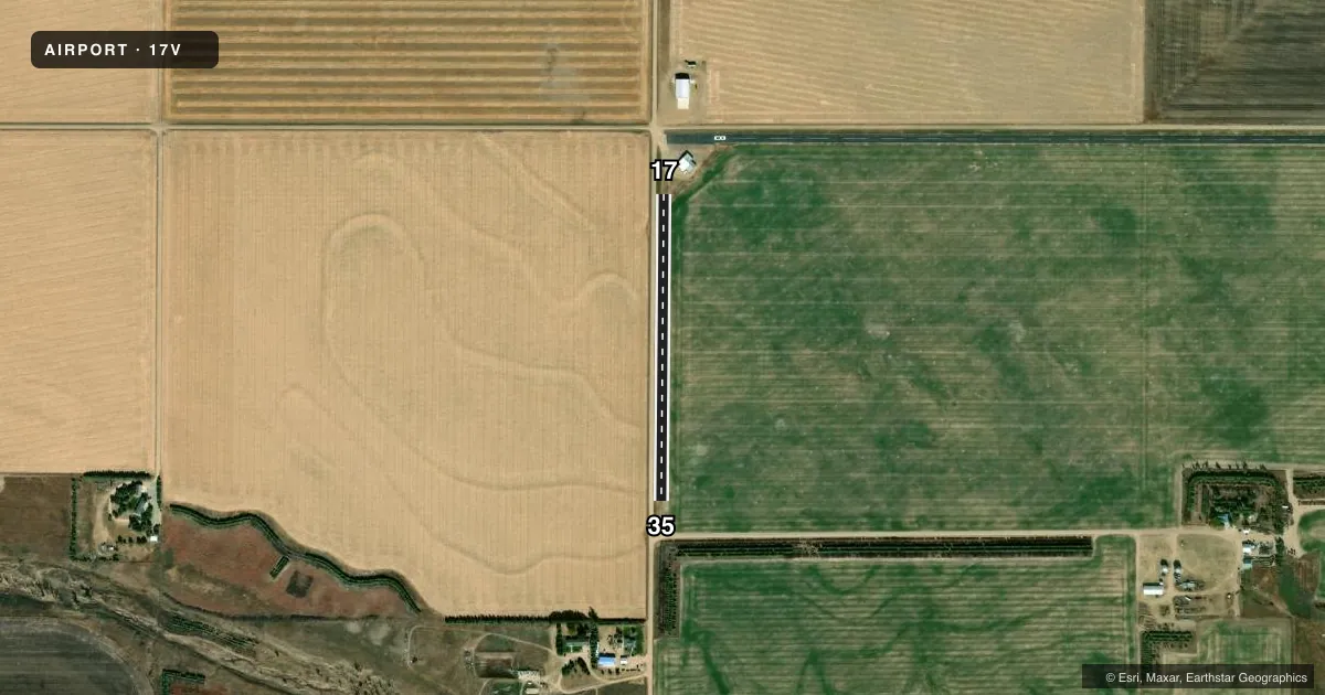
Airport sketch
Runways drawn to scale from FAA survey coordinates, rendered over satellite imagery. Not for navigation.
Approaches & charts
Services on the field
Fuel grades, oxygen, maintenance, ramp storage and lighting — as declared to the FAA by the airport operator.
Fuel & services
- Fuel
- Not available
Ramp & ground
- Transient storage
- Tie-down
- Landing fee
- No fee published
- Customs
- Not available
- Lighting schedule
- SS-SR
- Wind indicator
- Lighted
- Segmented circle
- No
Fuel & FBOs
Cheapest 100LL and Jet A on the field and nearby. Always confirm with the FBO before taxi.
Airport notes
Surface conditions, obstructions, local procedures, lighting outages and other notes published with each FAA cycle.
General notes
- GRVL ROAD PARLS BOTH RWYS 45-55 FT FM CNTRLNS.
- RWY EDGE SAFETY AREA N SIDE OF RWY 08/26 & W SIDE OF RWY 17/35 NA.
- CTN: UNL VEHICLE ACES TO ARPT.
- FOR CD CTC DENVER ARTCC AT 303-651-4257.
Runway surface & condition
- 08/26NSTD MIRL; NO THLD LGTS EDGE LGTS BGN 250 FT OF RWY 08 END - PCL.
Approach & departure obstructions
- 08+15 FT ROAD AT THR PARL TO CTNRLN 50 FT L; +15 FT ROAD 55 FM THR BOTH SIDES; +8 FT SIGN 50 FT FM THR 75 FT L.
- 2615 FT ROAD AT THR 50 FT R PARL TO CNTRLN FULL LEN.
- 08+20 FT HANGAR & 25 FT WIND CONE 300 FT E OF RWY THR 75 FT R.
- 35+40 FT TREES 575 FT FM THR 70 FT L OF CNTRLN; +45 FT ANTENNA 650 FT FM THR 150 FT L OF CNTRLN.
- 08CONTROLLING OBSTN EXCEEDS A 45 DEG SLP.
Other notes
- MANAGEREMERG - POLICE DISPATCH 970-774-6289.
- 17/35RWY MAINTAINED BUT SFC ROUGH.
VFR map & nearby airports
VFR sectional. Tap any ICAO chip to open that airport.
Key facts · 17V
Answer card- ICAO
- 17V
- Name
- HAXTUN MUNI
- Location
- HAXTUN, COLORADO
- Elevation
- 4,035 ft MSL
- Traffic pattern altitude
- 5,035 ft MSL (1,000 AGL)
- Control tower
- Non-towered (use CTAF)
- Total runways
- 1
- Longest runway
- 17/35 · 1,650 ft
- Published ILS approaches
- 0
- Published frequencies
- 1
- Magnetic variation
- 10°
- Current flight rules
- VFR
- Current wind
- 030° at 8 kt
- Favored runway now
- RWY 35
Haxtun Muni is in Haxtun, Colorado. The field elevation is 4,035 ft MSL. It has one runway. Runway 17/35 is 1,650 ft long with a turf-dirt surface. No tower is published here, so use CTAF 122.9 for local traffic calls.
No ILS approaches are published for 17V. The pattern altitude is not published, so use the standard 1,000 ft AGL unless the current FAA Chart Supplement says otherwise. That puts the light-piston pattern at 5,035 ft MSL based on the field elevation. Runway 17/35 is maintained, but the surface is reported rough. Plan for soft-field technique and a careful look at braking and rollout before you commit.
There are no on-field FBOs listed. Check with the airport operator or the FBO directly by phone before you go if you need fuel or local services. Published remarks also call out uncontrolled vehicle access on the airport. There are road and obstacle issues near the runway ends. A gravel road parallels both runways close in. The north side of runway 08/26 and the west side of runway 17/35 do not have runway edge safety area available. Clearance delivery is handled through Denver ARTCC when needed.