METAR & TAF 7V8
7V8 does not publish a METAR.
Showing the nearest reporting station: KHEQ (HOLYOKE) · 24.1 NM away. Conditions at 7V8 may differ.
METAR · KHEQ
Observed 12:35Z
KHEQ 271235Z AUTO 06010KT 10SM CLR 28/16 A2995 RMK AO2 T02800156
- Wind
- 060° @ 10 kt
- Visibility
- 10 SM
- Temp / Dew
- 28°C / 16°C
- Altimeter
- 29.95 inHg
- Clouds
- CLR
- Density alt
- 5,857 ft
- Ceiling
- Unlimited
- Rules
- VFR
Airport info & contacts
Manager on record, flight service, ARTCC, attendance schedule and pattern altitude — published by the FAA and refreshed every 28 days.
Location
- From city
- 3 NM SW
- VFR sectional
- CHEYENNE
- ARTCC
- ZDV · DENVER
- NOTAM facility
- DEN (NOTAM-D)
Airport manager
- Name
- GREG NEIN
- Phone
- 970-474-3344
- Address
- 100 W SECOND, JULESBURG CO 80737
Flight service · Hours
- FSS DEN
- DENVER1-800-WX-BRIEF
- Attendance
- Unattended
Frequencies
Tap any row to copy the frequency to your clipboard.
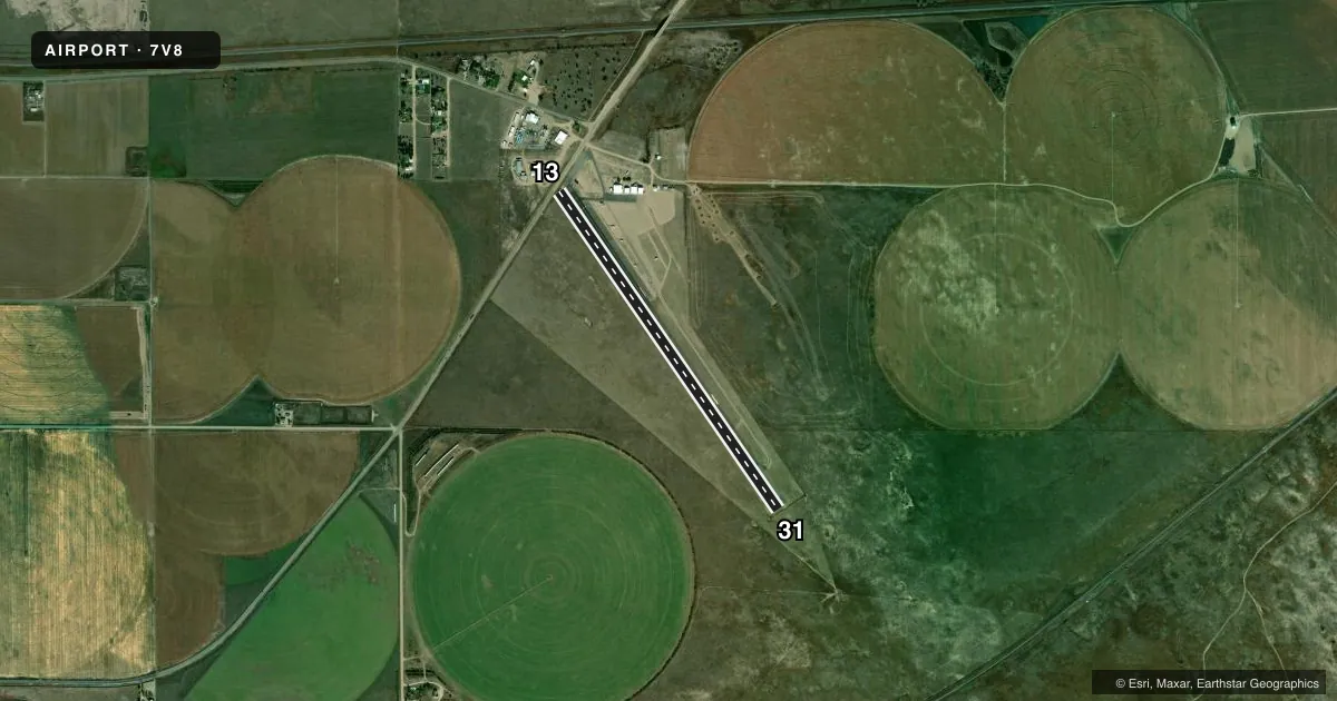
Runways & pattern
Full pagePattern entry · RWY 13
LEFT TRAFFICAirport sketch
Runways drawn to scale from FAA survey coordinates, rendered over satellite imagery. Not for navigation.
Approaches & charts
Services on the field
Fuel grades, oxygen, maintenance, ramp storage and lighting — as declared to the FAA by the airport operator.
Fuel & services
- Fuel
- Not available
- Oxygen (bottled)
- Not available
- Oxygen (bulk)
- Not available
- Airframe repair
- Not available
- Power plant repair
- Not available
Ramp & ground
- Transient storage
- Tie-down
- Landing fee
- No fee published
- Customs
- Not available
- Lighting schedule
- SEE RMK
- Beacon schedule
- SS-SR
- Beacon
- White / Green (civil land)(WG)
- Wind indicator
- Lighted
- Segmented circle
- No
Fuel & FBOs
Cheapest 100LL and Jet A on the field and nearby. Always confirm with the FBO before taxi.
Airport notes
Surface conditions, obstructions, local procedures, lighting outages and other notes published with each FAA cycle.
General notes
- WILDLIFE ON & INVOF ARPT.
- RY USED FOR DRAG RACING ON FRI-SUN FROM APR-SEP.
- RY 13 HAS +4 FT FENCE 350 FT FROM DSPLCD THR; +18 FT ROAD 410 FT FROM DSPLCD THR.
- 3 FT RAILING 112 FT N SIDE OF RY; FULL LENGTH.
- TAXIWAY CLOSED USE RUNWAY FOR BACK TAXI.
- FOR CD CTC DENVER ARTCC AT 303-651-4257.
- BLDGS 100 FT L & R OF RWY 13 THLD.
- CNCRT BARRIERS 5 FT L OF RWY 13 THLD.
Lighting notes
- MIRL RY 13/31 PRESET MED INTST DUSK-DAWN.
Approach & departure obstructions
- 13RY 13 HAS +5 FT FENCE 30 FT L OF CNTRLN AT PAVEMENT END. +19 FT RD 59 FT FROM THLD OB.
- 31+5 FT FENCE OB OF CNTRLN 50 FT FM END OF RWY.
- 13THLD & NUMBER OBSCURED BY RUBBER DEPOSITS.
- 31RY 13/31 NUMBERS SMALL.
- 13CTLG OBSTN EXCEEDS A 45 DEG SLP.
Other notes
- ESTABD PRIOR TO 1959.
- 1FOR SVC & ASSISTANCE CALL SHERIFFS OFFICE 970-474-3355.
- MANAGERCITY CLERKS OFC AFTER HRS PHONE 970-474-2124.
VFR map & nearby airports
VFR sectional. Tap any ICAO chip to open that airport.
Key facts · 7V8
Answer card- ICAO
- 7V8
- Name
- JULESBURG MUNI
- Location
- JULESBURG, COLORADO
- Elevation
- 3,495 ft MSL
- Traffic pattern altitude
- 4,495 ft MSL (1,000 AGL)
- Control tower
- Non-towered (use CTAF)
- Total runways
- 1
- Longest runway
- 13/31 · 4,100 ft
- Published ILS approaches
- 0
- Published frequencies
- 1
- Magnetic variation
- 10°
- Current flight rules
- VFR
- Current wind
- 060° at 10 kt
- Favored runway now
- RWY 13
Julesburg Muni is in Julesburg, Colorado. The field elevation is 3,495 ft MSL. It has one runway. Runway 13/31 is 4,100 ft long and asphalt. There is no control tower. CTAF is 122.9. No ILS approaches are published here. Pattern altitude is not published in the facts, so verify the current traffic pattern altitude before you go. The airport sits in open country near the Nebraska border. Expect a high-plains feel with little room for error if the wind is up.
The published remarks matter here. There is a 3 foot railing north of the runway that runs the full length. Runway 13 also has several nearby obstructions, including fences, a road and a threshold area with rubber deposits that obscure the runway number and threshold marking. There is also a cataloged obstruction near runway 13 that exceeds a 45 degree slope. Runway 31 has a fence obstruction near the end. Wildlife is reported on and near the airport. The runway is also used for drag racing Friday through Sunday from April through September. If you are planning a first visit, check the current FAA Chart Supplement and call the airport operator or the sheriff’s office for current field conditions. Also ask about any local activity before arrival.