METAR & TAF KGGF
Current METAR
Observed 13:15Z
KGGF 271315Z AUTO 06010KT 10SM CLR 27/19 A2992 RMK AO2
- Wind
- 060° @ 10 kt
- Visibility
- 10 SM
- Temp / Dew
- 27°C / 19°C
- Altimeter
- 29.92 inHg
- Clouds
- CLR
- Density alt
- 5,687 ft
- Ceiling
- Unlimited
- Rules
- VFR
Airport info & contacts
Manager on record, flight service, ARTCC, attendance schedule and pattern altitude — published by the FAA and refreshed every 28 days.
Location
- From city
- 2 NM N
- VFR sectional
- CHEYENNE
- ARTCC
- ZDV · DENVER
- NOTAM facility
- OLU (NOTAM-D)
Airport manager
- Name
- EDWARD DUNN
- Phone
- (308) 352-2100
- Address
- P.O. BOX 614, GRANT NE 69140-0614
Flight service · Hours
- FSS OLU
- COLUMBUS1-800-WX-BRIEF
- Attendance
- MON-FRI · 0800-1700
Frequencies
Tap any row to copy the frequency to your clipboard.
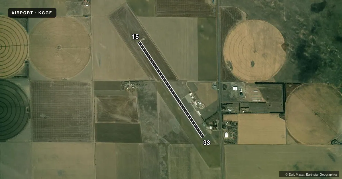
Runways & pattern
Full pagePattern entry · RWY 15
LEFT TRAFFICAirport sketch
Runways drawn to scale from FAA survey coordinates, rendered over satellite imagery. Not for navigation.
Approaches & charts
Services on the field
Fuel grades, oxygen, maintenance, ramp storage and lighting — as declared to the FAA by the airport operator.
Fuel & services
- Fuel
- 100LL
- Oxygen (bottled)
- Not available
- Oxygen (bulk)
- Not available
- Airframe repair
- Not available
- Power plant repair
- Not available
- Other services
- AGRI
Ramp & ground
- Transient storage
- Tie-down
- Hangar
- Landing fee
- No fee published
- Customs
- Not available
- Lighting schedule
- SEE RMK
- Beacon schedule
- SS-SR
- Beacon
- White / Green (civil land)(WG)
- Wind indicator
- Lighted
- Segmented circle
- Yes
Fuel & FBOs
Cheapest 100LL and Jet A on the field and nearby. Always confirm with the FBO before taxi.
Airport notes
Surface conditions, obstructions, local procedures, lighting outages and other notes published with each FAA cycle.
General notes
- FOR CD CTC DENVER ARTCC AT 303-651-4257.
- FBO ON ARPT MON - FRI 0800 - 1700, FLT INSTRN AVBL. CTC RYAN FLAMING 308-491-9001.
Lighting notes
- ACTVT MIRL RWY 15/33 - CTAF.
Fuel notes
- 100LLSELF SVC H24 VIA CREDIT CARD.
Other notes
- ESTABD PRIOR TO 1959.
VFR map & nearby airports
VFR sectional. Tap any ICAO chip to open that airport.
Key facts · KGGF
Answer card- ICAO
- KGGF
- Name
- GRANT MUNI
- Location
- GRANT, NEBRASKA
- Elevation
- 3,424.6 ft MSL
- Traffic pattern altitude
- 4,424.6 ft MSL (1,000 AGL)
- Control tower
- Non-towered (use CTAF)
- Total runways
- 1
- Longest runway
- 15/33 · 4,797 ft
- Published ILS approaches
- 0
- Published frequencies
- 2
- Magnetic variation
- 9°
- Current flight rules
- VFR
- Current wind
- 060° at 10 kt
- Favored runway now
- RWY 15
Grant Muni Airport sits in Grant, Nebraska. The field elevation is 3,424.6 ft MSL. It has one runway, 15/33, which is 4,797 ft long with a concrete surface. There is no control tower. CTAF and UNICOM are both 122.8. No ILS approaches are published here.
The pattern altitude is not published. Use the standard 1,000 ft AGL for light piston traffic unless the current Chart Supplement says otherwise. Hill Aviation is on the field. It carries 100LL. Self-serve 100LL is available 24 hours by credit card. The published remarks also note that the runway 15/33 medium intensity lights are activated by CTAF. That matters after dark because you need to key the lights before landing.
This is a high-elevation airport at 3,424.6 ft MSL. Expect density altitude to matter on warm days. For clearance delivery, the published remark points pilots to Denver ARTCC at 303-651-4257. The field is in a non-towered environment, so keep your radio calls tight and watch for local traffic. If you need current operational details, check the current FAA Chart Supplement or call the airport operator or the FBO directly.