METAR & TAF KOGA
Current METAR
Observed 14:55Z
KOGA 271455Z AUTO 06011G16KT 10SM CLR 31/21 A2995 RMK AO2 T03130205
- Wind
- 060° @ 11G16 kt
- Visibility
- 10 SM
- Temp / Dew
- 31°C / 21°C
- Altimeter
- 29.95 inHg
- Clouds
- CLR
- Density alt
- 5,949 ft
- Ceiling
- Unlimited
- Rules
- VFR
Airport info & contacts
Manager on record, flight service, ARTCC, attendance schedule and pattern altitude — published by the FAA and refreshed every 28 days.
Location
- From city
- 2 NM W
- VFR sectional
- CHEYENNE
- ARTCC
- ZDV · DENVER
- NOTAM facility
- OGA (NOTAM-D)
Airport manager
- Name
- KEVIN WILKINS
- Phone
- 308-284-6001
- Address
- 411 E 2ND STREET, OGALLALA NE 69153-2631
Flight service · Hours
- FSS OLU
- COLUMBUS1-800-WX-BRIEF
- Attendance
- MON-FRI · 0730-1630
Frequencies
Tap any row to copy the frequency to your clipboard.
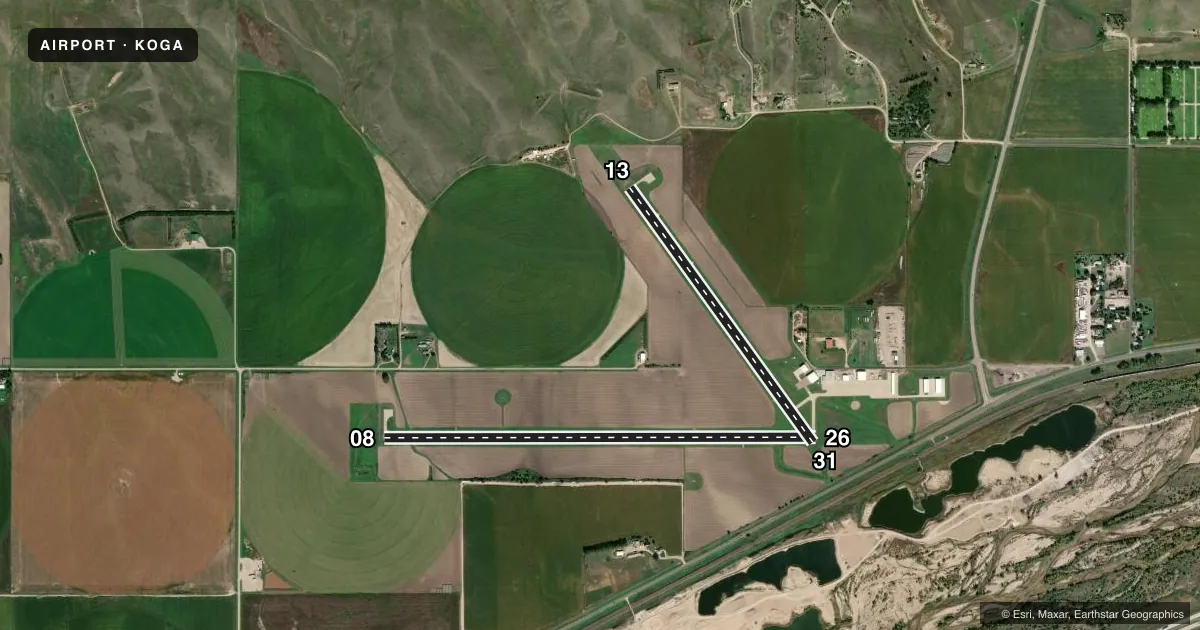
Runways & pattern
Full pagePattern entry · RWY 08
LEFT TRAFFIC| Runway | Heading (°M) | Length | Surface | Traffic |
|---|---|---|---|---|
| 08/26Favored | 83° / 263° | 5,102 ft | CONC | Standard L |
| 13/31 | 137° / 317° | 3,700 ft | CONC | Standard L |
Runway end performance
| End | TORA | TODA | ASDA | LDA | VGSI | Approach lights | Obstruction |
|---|---|---|---|---|---|---|---|
| 08 | — | — | — | — | PAPI 2-box left(3°) | — | — |
| 26 | — | — | — | — | PAPI 2-box left(3°) | — | — |
| 13 | — | — | — | — | VASI 4-box left(3.5°) | — | 30', road, 670' from thr, 320' R of cntrln, slope 15 |
| 31 | — | — | — | — | PAPI 2-box left(3°) | — | — |
Declared distances in feet. TORA = takeoff run available, TODA = takeoff distance, ASDA = accelerate-stop, LDA = landing distance.
Airport sketch
Runways drawn to scale from FAA survey coordinates, rendered over satellite imagery. Not for navigation.
Approaches & charts
Services on the field
Fuel grades, oxygen, maintenance, ramp storage and lighting — as declared to the FAA by the airport operator.
Fuel & services
- Fuel
- 100LLA+
- Oxygen (bottled)
- High pressure
- Airframe repair
- Major
- Power plant repair
- Major
- Other services
- AGRI
Ramp & ground
- Transient storage
- Tie-down
- Hangar
- Landing fee
- No fee published
- Customs
- Not available
- Lighting schedule
- SEE RMK
- Beacon schedule
- SS-SR
- Beacon
- White / Green (civil land)(WG)
- Wind indicator
- Lighted
- Segmented circle
- Yes
Fuel & FBOs
Cheapest 100LL and Jet A on the field and nearby. Always confirm with the FBO before taxi.
Airport notes
Surface conditions, obstructions, local procedures, lighting outages and other notes published with each FAA cycle.
General notes
- FOR CD IF UNA TO CTC ON FSS FREQ, CTC DENVER ARTCC AT 303-651-4257.
Lighting notes
- ACTVT PAPI RWY 08, 26 & 31; VASI RWY 13; MIRL RWY 13/31 & 08/26 - CTAF.
Approach & departure obstructions
- 08CALM WIND RWY.
- 08RWY 08 UNLGTD CNTR PIVOT SYS ROTS THRU APCH DURG IRRIGATION SEASON.
Other notes
- 1ARPT ATTENDANT MIKE CANDY CELL 308-289-4954. FOR ATTENDANT AFT HRS CALL 308-284-4447.
- MANAGERKEVIN.WILKINS@OGALLALA-NE.GOV
VFR map & nearby airports
VFR sectional. Tap any ICAO chip to open that airport.
Key facts · KOGA
Answer card- ICAO
- KOGA
- Name
- SEARLE FLD
- Location
- OGALLALA, NEBRASKA
- Elevation
- 3,279.3 ft MSL
- Traffic pattern altitude
- 4,279.3 ft MSL (1,000 AGL)
- Control tower
- Non-towered (use CTAF)
- Total runways
- 2
- Longest runway
- 08/26 · 5,102 ft
- Published ILS approaches
- 0
- Published frequencies
- 2
- Magnetic variation
- 7°
- Current flight rules
- VFR
- Current wind
- 060° at 11 kt
- Favored runway now
- RWY 08
Searle Fld is in Ogallala, Nebraska. The field elevation is 3,279.3 ft MSL. It has two concrete runways. The longest is runway 08/26 at 5,102 ft. There is no control tower, so plan for CTAF self-announce work on 122.8.
No ILS approaches are published here. The pattern altitude is not published, so use the standard 1,000 ft AGL pattern for light piston operations unless the current Chart Supplement says otherwise. The on-field FBO is Searle Field. It carries 100LL and Jet A. Call ahead at (308) 284-3848 if you need current service details.
A few operational notes matter here. Runway 08 is listed as the calm wind runway. Runway 08 also has an unlighted center pivot irrigation system that can rotate through the approach during irrigation season. Lighting is available on both runways. PAPI is active on 08, 26 and 31. VASI is active on 13. Medium intensity runway lights are on 08/26 and 13/31. All lighting is controlled by the CTAF. If you need clearance delivery help and cannot reach Flight Service, the published remark points pilots to Denver Center. This is a good field for a careful brief before arrival, especially if you are planning a night or low-visibility stop.