METAR & TAF KOKS
KOKS does not publish a METAR.
Showing the nearest reporting station: KOGA (SEARLE FLD) · 31.4 NM away. Conditions at KOKS may differ.
METAR · KOGA
Observed 12:15Z
KOGA 271215Z AUTO 04011KT 10SM CLR 30/18 A2993 RMK AO2 T02970181
- Wind
- 040° @ 11 kt
- Visibility
- 10 SM
- Temp / Dew
- 30°C / 18°C
- Altimeter
- 29.93 inHg
- Clouds
- CLR
- Density alt
- 5,996 ft
- Ceiling
- Unlimited
- Rules
- VFR
Airport info & contacts
Manager on record, flight service, ARTCC, attendance schedule and pattern altitude — published by the FAA and refreshed every 28 days.
Location
- From city
- 1 NM SW
- VFR sectional
- CHEYENNE
- ARTCC
- ZDV · DENVER
- NOTAM facility
- OLU (NOTAM-D)
Airport manager
- Name
- WHITNEY ROTHWELL
- Phone
- 308-650-0890
- Address
- 5648 HWY 27, OSHKOSH NE 69154-0038
Flight service · Hours
- FSS OLU
- COLUMBUS1-800-WX-BRIEF
- Attendance
- Unattended
Frequencies
Tap any row to copy the frequency to your clipboard.
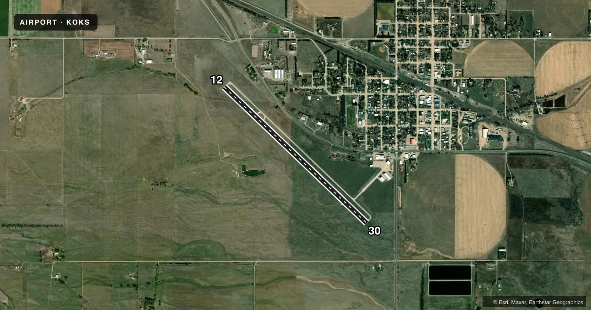
Runways & pattern
Full pagePattern entry · RWY 30
LEFT TRAFFICRunway end performance
| End | TORA | TODA | ASDA | LDA | VGSI | Approach lights | Obstruction |
|---|---|---|---|---|---|---|---|
| 12 | — | — | — | — | PAPI 2-box left(3°) | — | — |
| 30 | — | — | — | — | PAPI 2-box left(3°) | — | — |
Declared distances in feet. TORA = takeoff run available, TODA = takeoff distance, ASDA = accelerate-stop, LDA = landing distance.
Airport sketch
Runways drawn to scale from FAA survey coordinates, rendered over satellite imagery. Not for navigation.
Approaches & charts
Services on the field
Fuel grades, oxygen, maintenance, ramp storage and lighting — as declared to the FAA by the airport operator.
Fuel & services
- Fuel
- 100LLAA+
- Oxygen (bottled)
- Not available
- Oxygen (bulk)
- Not available
- Airframe repair
- Major
- Power plant repair
- Major
- Other services
- AGRI
Ramp & ground
- Transient storage
- Tie-down
- Hangar
- Landing fee
- No fee published
- Customs
- Not available
- Lighting schedule
- SEE RMK
- Beacon schedule
- SS-SR
- Beacon
- White / Green (civil land)(WG)
- Wind indicator
- Lighted
- Segmented circle
- No
Fuel & FBOs
Cheapest 100LL and Jet A on the field and nearby. Always confirm with the FBO before taxi.
Airport notes
Surface conditions, obstructions, local procedures, lighting outages and other notes published with each FAA cycle.
General notes
- FOR CD CTC DENVER ARTCC AT 303-651-4257.
Lighting notes
- ACTIVATE MIRL, PAPI & REIL RWY 12 & 30 - CTAF.
Fuel notes
- 100LL24 HR SELF SVC FUEL AVBL VIA CREDIT CARD SYSTEM.
Approach & departure obstructions
- 12RWY 12 CLNC SLOPE 27:1 TO RWY THR DUE TO TREE 1586 FT FM & 50 FT ABV RWY END; 325 RIGHT.
- 30RWY 30 CLNC SLOPE 26:1 TO RWY THR DUE TO TREE 1322 FT FM & 42 FT ABV RWY END; 245 L.
VFR map & nearby airports
VFR sectional. Tap any ICAO chip to open that airport.
Key facts · KOKS
Answer card- ICAO
- KOKS
- Name
- GARDEN COUNTY/KING RHILEY FLD
- Location
- OSHKOSH, NEBRASKA
- Elevation
- 3,394.1 ft MSL
- Traffic pattern altitude
- 4,394.1 ft MSL (1,000 AGL)
- Control tower
- Non-towered (use CTAF)
- Total runways
- 1
- Longest runway
- 12/30 · 4,699 ft
- Published ILS approaches
- 0
- Published frequencies
- 2
- Magnetic variation
- 9°
- Current flight rules
- VFR
- Current wind
- 040° at 11 kt
- Favored runway now
- RWY 30
Garden County/King Rhiley Fld (KOKS) sits in Oshkosh, Nebraska. The field elevation is 3,394.1 ft MSL. It has one runway. Runway 12/30 is 4,699 ft long with a concrete surface. There is no control tower. CTAF and UNICOM are both 122.8.
No ILS approaches are published here. Pattern altitude is not published in the facts, so use standard 1,000 ft AGL for light piston traffic unless the current FAA Chart Supplement says otherwise. That puts the pattern at about 4,394 ft MSL based on the listed field elevation. The airport is served by Garden County Airport on the field. It carries 100LL and Jet A. Twenty-four hour self-serve 100LL is available by credit card system.
This is a high-elevation airport, so expect thinner air and longer takeoff rolls than you would see at lower fields. The published remarks also call out runway lighting, PAPI and REIL activation on CTAF for runways 12 and 30. There are tree obstructions near both runway ends, so pay close attention to the published clearance slopes and plan your approach and departure performance with margin. For clearance delivery, contact Denver ARTCC. Check the current FAA Chart Supplement before you go for any updates to lighting, procedures, or local restrictions.