METAR & TAF KSNY
Current METAR
Observed 01:53Z
KSNY 010153Z AUTO 33018G24KT 6SM TSRA BKN075 OVC090 21/10 A2981 RMK AO2 LTG DSNT S-W RAB19E32B47 TSB12E27B44 SLP046 P0005 T02060100
- Wind
- 330° @ 18G24 kt
- Visibility
- 6 SM
- Temp / Dew
- 21°C / 10°C
- Altimeter
- 29.81 inHg
- Clouds
- OVC
- Density alt
- 6,206 ft
- Ceiling
- 7,500 ft AGL
- Rules
- VFR
Airport info & contacts
Manager on record, flight service, ARTCC, attendance schedule and pattern altitude — published by the FAA and refreshed every 28 days.
Location
- From city
- 3 NM S
- VFR sectional
- CHEYENNE
- ARTCC
- ZDV · DENVER
- NOTAM facility
- SNY (NOTAM-D)
Airport manager
- Name
- GEORGE LAPASEOTES
- Phone
- (308) 254-5058
- Address
- 11149 ROAD 16, SIDNEY NE 69162-4002
Flight service · Hours
- FSS OLU
- COLUMBUS1-800-WX-BRIEF
- Attendance
- 0700-1800
Frequencies
Tap any row to copy the frequency to your clipboard.
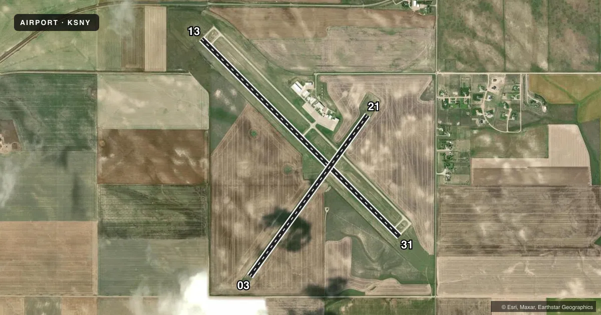
Runways & pattern
Full pagePattern entry · RWY 31
LEFT TRAFFIC| Runway | Heading (°M) | Length | Surface | Traffic |
|---|---|---|---|---|
| 13/31Favored | 124° / 304° | 6,600 ft | CONC | Standard L |
| 03/21 | 25° / 205° | 4,705 ft | TURF | Standard L |
Runway end performance
| End | TORA | TODA | ASDA | LDA | VGSI | Approach lights | Obstruction |
|---|---|---|---|---|---|---|---|
| 13 | — | — | — | — | PAPI 2-box left(3°) | — | — |
| 31 | — | — | — | — | PAPI 2-box left(3°) | — | — |
Declared distances in feet. TORA = takeoff run available, TODA = takeoff distance, ASDA = accelerate-stop, LDA = landing distance.
Airport sketch
Runways drawn to scale from FAA survey coordinates, rendered over satellite imagery. Not for navigation.
Approaches & charts
Services on the field
Fuel grades, oxygen, maintenance, ramp storage and lighting — as declared to the FAA by the airport operator.
Fuel & services
- Fuel
- 100LLA
- Oxygen (bottled)
- Low pressure
- Oxygen (bulk)
- Not available
- Airframe repair
- Major
- Power plant repair
- Minor
- Other services
- INSTR,RNTL
Ramp & ground
- Transient storage
- Tie-down
- Hangar
- Landing fee
- No fee published
- Customs
- Not available
- Lighting schedule
- SEE RMK
- Beacon schedule
- SS-SR
- Beacon
- White / Green (civil land)(WG)
- Wind indicator
- Yes
- Segmented circle
- Yes
Fuel & FBOs
Cheapest 100LL and Jet A on the field and nearby. Always confirm with the FBO before taxi.
Airport notes
Surface conditions, obstructions, local procedures, lighting outages and other notes published with each FAA cycle.
General notes
- FOR CD CTC DENVER ARTCC ON FREQ. IF UNA, CTC FSS ON FREQ VIA RCO. IF UNA, CTC DENVER ARTCC AT 303-651-4257.
Lighting notes
- DUSK-DAWN. ACTVT HIRL RY 13/31 & REIL RYS 13 & 31 - CTAF.
Approach & departure obstructions
- 31UNUSBL BYD 8 DEGS RIGHT OF CNTRLN.
- 03RWY 03 CLNC SLOPE 28:1 TO RWY THR CONES DUE TO PLINE 566 FT FM & 20 FT ABV RWY END, ON CNTRLN.
- 13RWY 13 CLNC SLOPE 50:1 TO RWY THR.
- 21RWY 21 CLNC SLOPE 40:1 TO RWY THR CONES DUE TO HILL 366 FT FM & 9 FT ABV RWY END.
- 31RWY 31 CLNC SLOPE 50:1 TO RWY THR.
Other notes
- 1AFTER HRS CALL 308-254-5058.
- OWNERRON MEYER, CHAIRMAN, AIRPORT AUTHORITY
- MANAGERMGR CAN ALSO BE REACHED AT 308-641-2584.
VFR map & nearby airports
VFR sectional. Tap any ICAO chip to open that airport.
Key facts · KSNY
Answer card- ICAO
- KSNY
- Name
- SIDNEY MUNI/LLOYD W CARR FLD
- Location
- SIDNEY, NEBRASKA
- Elevation
- 4,314.2 ft MSL
- Traffic pattern altitude
- 5,314.2 ft MSL (1,000 AGL)
- Control tower
- Non-towered (use CTAF)
- Total runways
- 2
- Longest runway
- 13/31 · 6,600 ft
- Published ILS approaches
- 0
- Published frequencies
- 2
- Magnetic variation
- 11°
- Current flight rules
- VFR
- Current wind
- 330° at 18 kt
- Favored runway now
- RWY 31
Sidney Muni/Lloyd W Carr Fld sits in Sidney, Nebraska. The field elevation is 4,314.2 ft MSL. It has two runways. The longest is 13/31 at 6,600 ft. This is a non-towered airport, so plan on self-announce traffic on CTAF 122.8. Lighting is available from dusk to dawn. High intensity runway lights on 13/31 are CTAF activated. Runway end identifier lights are also activated by CTAF on 13 and 31.
No ILS approaches are published here. Pattern altitude is not published, so use the standard 1,000 ft AGL pattern for light piston operations unless current local guidance says otherwise. L&L Aviation is on the field. It carries 100LL and Jet A Prist. For after-hours help, the published remarks say to call the FBO phone number.
This is a high-elevation field, so performance planning matters. Density altitude can be a factor, especially on warm days. Runway 03 has a power line near the departure end. Runway 21 has a hill near the departure end. Runway 31 is unusable beyond 8 degrees right of centerline. Check the current FAA Chart Supplement before you go. That is the best place to confirm any current operational notes, clearance delivery details, or changes to lighting and runway status.