METAR & TAF KCNP
KCNP does not publish a METAR.
Showing the nearest reporting station: KSNY (SIDNEY MUNI/LLOYD W CARR FLD) · 23.6 NM away. Conditions at KCNP may differ.
METAR · KSNY
Observed 01:53Z
KSNY 010153Z AUTO 33018G24KT 6SM TSRA BKN075 OVC090 21/10 A2981 RMK AO2 LTG DSNT S-W RAB19E32B47 TSB12E27B44 SLP046 P0005 T02060100
- Wind
- 330° @ 18G24 kt
- Visibility
- 6 SM
- Temp / Dew
- 21°C / 10°C
- Altimeter
- 29.81 inHg
- Clouds
- OVC
- Density alt
- 5,422 ft
- Ceiling
- 7,500 ft AGL
- Rules
- VFR
Airport info & contacts
Manager on record, flight service, ARTCC, attendance schedule and pattern altitude — published by the FAA and refreshed every 28 days.
Location
- From city
- 1 NM S
- VFR sectional
- CHEYENNE
- ARTCC
- ZDV · DENVER
- NOTAM facility
- OLU (NOTAM-D)
Airport manager
- Name
- CHRIS RAY
- Phone
- 308-874-4350
- Address
- PO BOX 546, CHAPPELL NE 69129-0546
Flight service · Hours
- FSS OLU
- COLUMBUS1-800-WX-BRIEF
- Attendance
- Unattended
Frequencies
Tap any row to copy the frequency to your clipboard.
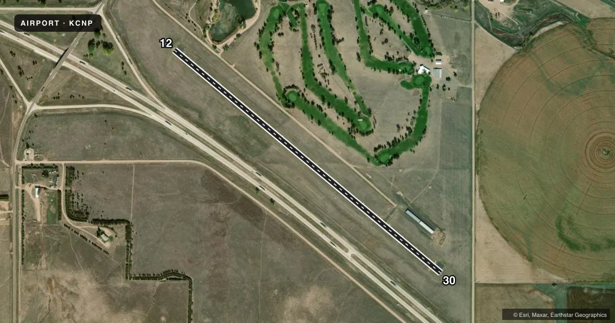
Runways & pattern
Full pagePattern entry · RWY 30
LEFT TRAFFICRunway end performance
| End | TORA | TODA | ASDA | LDA | VGSI | Approach lights | Obstruction |
|---|---|---|---|---|---|---|---|
| 12 | — | — | — | — | — | — | 30', road, 709' from thr, 288' R of cntrln, slope 16 |
| 30 | — | — | — | — | — | — | 11', road, 371' from thr, 155' R of cntrln, slope 15 |
Declared distances in feet. TORA = takeoff run available, TODA = takeoff distance, ASDA = accelerate-stop, LDA = landing distance.
Airport sketch
Runways drawn to scale from FAA survey coordinates, rendered over satellite imagery. Not for navigation.
Approaches & charts
Services on the field
Fuel grades, oxygen, maintenance, ramp storage and lighting — as declared to the FAA by the airport operator.
Fuel & services
- Fuel
- 100LL
- Oxygen (bottled)
- Not available
- Oxygen (bulk)
- Not available
- Airframe repair
- Not available
- Power plant repair
- Not available
Ramp & ground
- Transient storage
- Tie-down
- Hangar
- Landing fee
- No fee published
- Lighting schedule
- SEE RMK
- Beacon schedule
- SS-SR
- Beacon
- White / Green (civil land)(WG)
- Wind indicator
- Lighted
- Segmented circle
- No
Fuel & FBOs
Cheapest 100LL and Jet A on the field and nearby. Always confirm with the FBO before taxi.
Airport notes
Surface conditions, obstructions, local procedures, lighting outages and other notes published with each FAA cycle.
General notes
- FOR CD CTC DENVER ARTCC AT 303-651-4257.
Lighting notes
- MIRL RWY 12/30 PRESET LOW INTST; TO INCR INTST ACTVT - CTAF.
Approach & departure obstructions
- 30APCH SLOPE 45:1 TO DSPLCD THLD.
Other notes
- THIS AIRPORT HAS BEEN SURVEYED BY THE NATIONAL GEODETIC SURVEY.
- PRVDD APCH TO EACH RWY IS MAINT FOR A 20:1 GLIDE SLOPE & TRSNL SFC MAINT FOR A 7:1 SLOPE.
- CALL FOR HANGAR AVBL 308-874-4350.
- 12/30SEVERE BLOCK CRACKING AND FOD THRU OUT PVMNT.
VFR map & nearby airports
VFR sectional. Tap any ICAO chip to open that airport.
Key facts · KCNP
Answer card- ICAO
- KCNP
- Name
- BILLY G RAY FLD
- Location
- CHAPPELL, NEBRASKA
- Elevation
- 3,681.7 ft MSL
- Traffic pattern altitude
- 4,681.7 ft MSL (1,000 AGL)
- Control tower
- Non-towered (use CTAF)
- Total runways
- 1
- Longest runway
- 12/30 · 4,000 ft
- Published ILS approaches
- 0
- Published frequencies
- 1
- Magnetic variation
- 10°
- Current flight rules
- VFR
- Current wind
- 330° at 18 kt
- Favored runway now
- RWY 30
BILLY G RAY FLD is in Chappell, Nebraska. The field elevation is 3,681.7 ft MSL. It has one runway, 12/30, which is 4,000 ft long and asphalt. There is no control tower. CTAF is 122.9.
No ILS approaches are published here. The runway headings are 130° and 310° magnetic. Pattern altitude is not published, so use standard 1,000 ft AGL for light piston operations unless the current Chart Supplement says otherwise. That puts the pattern at about 4,681.7 ft MSL based on the listed field elevation.
Published remarks matter here. The pavement on 12/30 has severe block cracking and foreign object debris throughout. The runway lights are medium intensity. They come up at low intensity by default. Use CTAF to increase intensity. Approach notes also mention a displaced threshold and a 45:1 approach slope there. This is a high-elevation field on the Nebraska plains, so performance planning matters on warm days.
No on-field FBOs are listed. Check with the airport operator directly before arrival for services or hangar availability. Clearance delivery is handled through Denver ARTCC at 303-651-4257.