METAR & TAF 82V
Current METAR
Observed 17:15Z
K82V 271715Z AUTO 20007KT 7SM -RA OVC110 26/15 A3019 RMK AO2 RAB1712 P0000 T02600151 $
- Wind
- 200° @ 7 kt
- Visibility
- 7 SM
- Temp / Dew
- 26°C / 15°C
- Altimeter
- 30.19 inHg
- Clouds
- OVC
- Density alt
- 7,374 ft
- Ceiling
- 11,000 ft AGL
- Rules
- VFR
Airport info & contacts
Manager on record, flight service, ARTCC, attendance schedule and pattern altitude — published by the FAA and refreshed every 28 days.
Location
- From city
- 3 NM SW
- VFR sectional
- CHEYENNE
- ARTCC
- ZDV · DENVER
- NOTAM facility
- CPR (NOTAM-D)
Airport manager
- Name
- KEVIN MARQUARDT
- Phone
- 307-338-5118
- Address
- BOX 726, PINE BLUFFS WY 82082
Flight service · Hours
- FSS CPR
- CASPER1-800-WX-BRIEF
- Attendance
- MON-FRI · 0700-1600
Frequencies
Tap any row to copy the frequency to your clipboard.
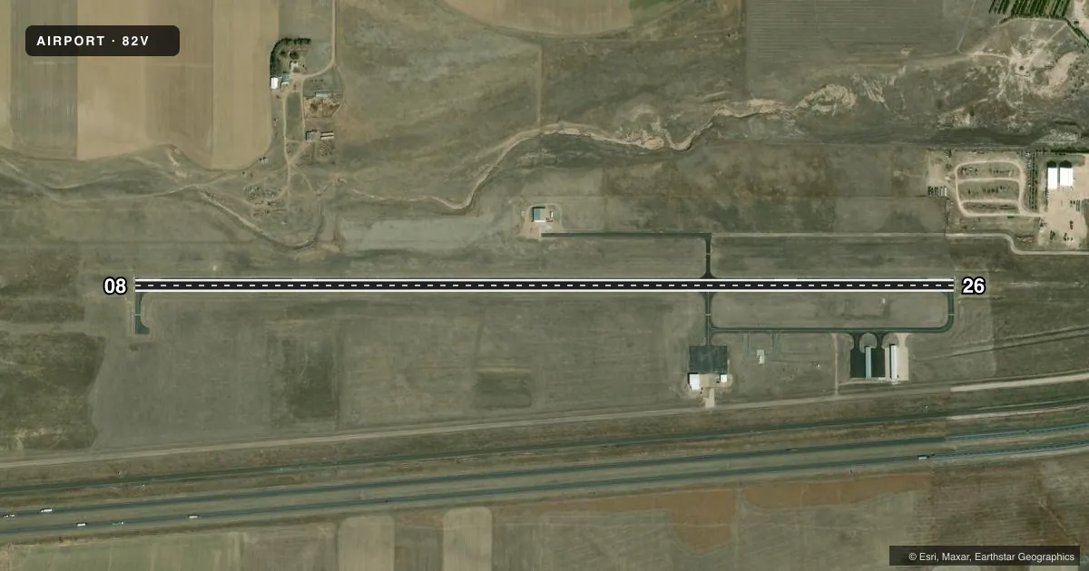
Runways & pattern
Full pagePattern entry · RWY 26
LEFT TRAFFICRunway end performance
| End | TORA | TODA | ASDA | LDA | VGSI | Approach lights | Obstruction |
|---|---|---|---|---|---|---|---|
| 08 | — | — | — | — | PAPI 2-box left(3°) | — | — |
| 26 | — | — | — | — | PAPI 2-box left(3°) | — | — |
Declared distances in feet. TORA = takeoff run available, TODA = takeoff distance, ASDA = accelerate-stop, LDA = landing distance.
Airport sketch
Runways drawn to scale from FAA survey coordinates, rendered over satellite imagery. Not for navigation.
Approaches & charts
Services on the field
Fuel grades, oxygen, maintenance, ramp storage and lighting — as declared to the FAA by the airport operator.
Fuel & services
- Fuel
- 100LL
- Oxygen (bottled)
- Not available
- Oxygen (bulk)
- Not available
- Airframe repair
- Major
- Power plant repair
- Major
- Other services
- AGRI,INSTR
Ramp & ground
- Transient storage
- Tie-down
- Hangar
- Landing fee
- No fee published
- Customs
- Not available
- Lighting schedule
- SEE RMK
- Beacon schedule
- SS-SR
- Beacon
- White / Green (civil land)(WG)
- Wind indicator
- Lighted
- Segmented circle
- Yes
Fuel & FBOs
Cheapest 100LL and Jet A on the field and nearby. Always confirm with the FBO before taxi.
Airport notes
Surface conditions, obstructions, local procedures, lighting outages and other notes published with each FAA cycle.
General notes
- FOR CD CTC DENVER ARTCC AT 303-651-4257.
Lighting notes
- ACTVT MIRL RY 08/26, PAPI RYS 08 & 26, REIL RYS 08 & 26 & WIND TEE - 122.8.
Fuel notes
- 100LLFUEL AVBL 24 HOURS A DAY WITH CREDIT CARD SELF SERVE.
Other notes
- PILOT SUPPLIED ROPES RQRD.
- 1FOR SVC AFT HRS PHONE 307-274-6954.
VFR map & nearby airports
VFR sectional. Tap any ICAO chip to open that airport.
Key facts · 82V
Answer card- ICAO
- 82V
- Name
- PINE BLUFFS MUNI
- Location
- PINE BLUFFS, WYOMING
- Elevation
- 5,152.1 ft MSL
- Traffic pattern altitude
- 6,152.1 ft MSL (1,000 AGL)
- Control tower
- Non-towered (use CTAF)
- Total runways
- 1
- Longest runway
- 08/26 · 5,330 ft
- Published ILS approaches
- 0
- Published frequencies
- 2
- Magnetic variation
- 7°
- Current flight rules
- VFR
- Current wind
- 200° at 7 kt
- Favored runway now
- RWY 26
Pine Bluffs Muni sits in Pine Bluffs, Wyoming. Field elevation is 5,152.1 ft MSL. The airport has one runway. Runway 08/26 is 5,330 ft of asphalt, which gives you the longest runway on the field. There is no control tower. CTAF and UNICOM are both 122.8. No ILS approaches are published here.
The pattern altitude is not published. For light piston traffic, plan on the standard 1,000 ft AGL pattern unless current local guidance says otherwise. The field is in a high-elevation part of Wyoming, so performance planning matters. Expect thinner air than you would at lower fields. Verify takeoff and landing numbers before you go.
The on-field FBO is Pine Bluffs Municipal Airport. It carries 100LL. Fuel is available 24 hours a day with credit card self-service. After-hours service is listed by phone at 307-274-6954. Published remarks also note that medium intensity runway lights are on 08/26. PAPI and REIL are available on both runway ends. Pilot supplied ropes are required. For clearance delivery, contact Denver ARTCC at 303-651-4257.