METAR & TAF KBFF
Current METAR
Observed 12:53Z
KBFF 271253Z AUTO 29004KT 10SM CLR 23/17 A3004 RMK AO2 SLP110 T02330167 $
- Wind
- 290° @ 4 kt
- Visibility
- 10 SM
- Temp / Dew
- 23°C / 17°C
- Altimeter
- 30.04 inHg
- Clouds
- CLR
- Density alt
- 5,731 ft
- Ceiling
- Unlimited
- Rules
- VFR
Airport info & contacts
Manager on record, flight service, ARTCC, attendance schedule and pattern altitude — published by the FAA and refreshed every 28 days.
Location
- From city
- 3 NM E
- VFR sectional
- CHEYENNE
- ARTCC
- ZDV · DENVER
- NOTAM facility
- BFF (NOTAM-D)
Airport manager
- Name
- RAUL AGUALLO
- Phone
- (308) 631-7449
- Address
- 250023 AIRPORT TERMINAL ST., SUITE 10, SCOTTSBLUFF NE 69361
Flight service · Hours
- FSS OLU
- COLUMBUS1-800-WX-BRIEF
- Attendance
- 0600-2100
Frequencies
Tap any row to copy the frequency to your clipboard.
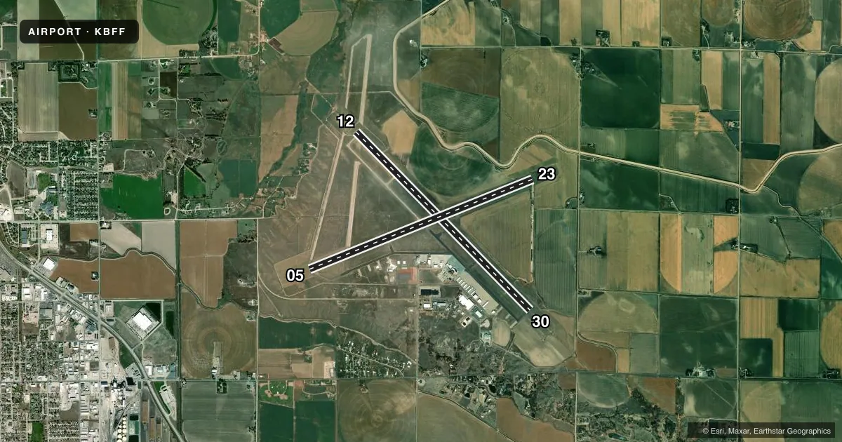
Runways & pattern
Full pagePattern entry · RWY 30
LEFT TRAFFIC| Runway | Heading (°M) | Length | Surface | Traffic |
|---|---|---|---|---|
| 12/30Favored | 126° / 306° | 8,279 ft | ASPH | Standard L |
| 05/23 | 58° / 238° | 8,002 ft | ASPH | Standard L |
Runway end performance
| End | TORA | TODA | ASDA | LDA | VGSI | Approach lights | Obstruction |
|---|---|---|---|---|---|---|---|
| 12 | 8,279' | 8,279' | 8,279' | 8,279' | PAPI 4-box left(3°) | MALSR | — |
| 30 | 8,279' | 8,279' | 8,279' | 8,279' | PAPI 4-box left(3°) | MALSR | — |
| 05 | 8,002' | 8,002' | 8,002' | 8,002' | VASI 4-box left(3°) | — | — |
| 23 | 8,002' | 8,002' | 8,002' | 8,002' | PAPI 4-box left(3°) | — | 31', road, 1650' from thr, 0' R of cntrln, slope 46 |
Declared distances in feet. TORA = takeoff run available, TODA = takeoff distance, ASDA = accelerate-stop, LDA = landing distance.
Airport sketch
Runways drawn to scale from FAA survey coordinates, rendered over satellite imagery. Not for navigation.
Approaches & charts
ILS · 2
Services on the field
Fuel grades, oxygen, maintenance, ramp storage and lighting — as declared to the FAA by the airport operator.
Fuel & services
- Fuel
- 100LLA
- Oxygen (bottled)
- Not available
- Oxygen (bulk)
- Low pressure
- Airframe repair
- Major
- Power plant repair
- Major
- Other services
- AFRT,AGRI,CHTR,GLD,INSTR,SALES,SURV,TOW
Ramp & ground
- Transient storage
- Tie-down
- Hangar
- Landing fee
- No fee published
- Customs
- Not available
- Lighting schedule
- SEE RMK
- Beacon schedule
- SS-SR
- Beacon
- White / Green (civil land)(WG)
- Wind indicator
- Lighted
- Segmented circle
- No
Fuel & FBOs
Cheapest 100LL and Jet A on the field and nearby. Always confirm with the FBO before taxi.
Airport notes
Surface conditions, obstructions, local procedures, lighting outages and other notes published with each FAA cycle.
General notes
- RY 30 DESIGNATED CALM WIND RY.
- WATERFOWL ON & INVOF ARPT.
- LINE OF SITE RESTRICTIONS BTWN APCH ENDS OF RYS 05 & 30 & ALSO BTWN THE APCH ENDS OF RYS 12 & 23.
- APRON PAVEMENT STRENGTH, S-85, D-117, DT-232. PCN IS 31/R/A/W/T.
- AC AND DC GROUND POWER UNITS AVAILABLE
- LAVATORY SERVICE AVAILABLE
- FOR CD CTC DENVER ARTCC ON FREQ. IF UNA, CTC FSS ON FREQ VIA RCO. IF UNA, CTC DENVER ARTCC AT 303-651-4257.
Lighting notes
- ACTVT MIRL RY 05/23; HIRL RY 12/30; MALSR RYS 12 & 30 & VASI RY 05 & PAPI RYS 12 , 23 AND 30 - CTAF.
Runway surface & condition
- 05/23PCR VALUE: 2472/F/C/X/T
- 12/30PCR VALUE: 2472/F/C/X/T
Other notes
- PER AMGR USE CTAF WHEN OPERATING ON THE ARPT.
- PPR 24 HRS FOR ACR OPNS WITH MORE THAN 30 PSGR SEATS CALL AMGR 308-635-4941. AIR CARRIER OPS OVER 9 PASSENGER SEATS NOT AUTHORIZED IN EXCESS OF 15 MINUTES BEFORE OR AFTER SCHEDULED ARRIVAL/DEP TIMES EXCEPT WITH PRIOR COORDINATION WITH AIRPORT MGR. ARFF INDEX B EQUIPMENT IS PROVIDED.
- 1FOR SVC AFTER HRS CALL 308-635-0162.
- MANAGERCELL PHONE 308-631-8098 OR 308-631-1591.
VFR map & nearby airports
VFR sectional. Tap any ICAO chip to open that airport.
Key facts · KBFF
Answer card- ICAO
- KBFF
- Name
- SCOTTSBLUFF/WESTERN NEBRASKA RGNL/WM B HEILIG FLD
- Location
- SCOTTSBLUFF, NEBRASKA
- Elevation
- 3,967.3 ft MSL
- Traffic pattern altitude
- 4,967.3 ft MSL (1,000 AGL)
- Control tower
- Non-towered (use CTAF)
- Total runways
- 2
- Longest runway
- 12/30 · 8,279 ft
- Published ILS approaches
- 2
- Published frequencies
- 2
- Magnetic variation
- 10°
- Current flight rules
- VFR
- Current wind
- 290° at 4 kt
- Favored runway now
- RWY 30
KBFF sits in Scottsbluff, Nebraska at 3,967.3 ft MSL. It has two asphalt runways. The longest is 8,279 ft on runway 12/30. There is no control tower, so use CTAF 123.0 for traffic and runway coordination. The field has two ILS approaches. They serve runways 12 and 30. Pattern altitude is not published. Use 1,000 ft AGL for light piston operations unless the current Chart Supplement says otherwise.
Valley Airways is on the field. It carries 100LL and Jet A. Classic Aircraft Service is also on the field. It carries 100LL and Jet A Prist. The airport remarks also note runway lighting details that matter after sunset. Runway 12/30 has high intensity lighting. Runway 05/23 has medium intensity lighting. PAPI is available on runways 12, 23 and 30. VASI is on runway 05.
This is a high-elevation airport, so performance planning matters. Expect density altitude to be a real factor in warm weather. Waterfowl are present on and near the airport. There are also line of sight restrictions between the approach ends of 05 and 30. The same issue exists between 12 and 23. Runway 30 is the calm wind runway. Check the current Chart Supplement for any noise or curfew restrictions before flying in.