METAR & TAF KCDR
Current METAR
Observed 03:53Z
KCDR 270353Z AUTO 05005KT 10SM CLR 27/12 A2991 RMK AO2 SLP091 T02720122
- Wind
- 050° @ 5 kt
- Visibility
- 10 SM
- Temp / Dew
- 27°C / 12°C
- Altimeter
- 29.91 inHg
- Clouds
- CLR
- Density alt
- 5,542 ft
- Ceiling
- Unlimited
- Rules
- VFR
Airport info & contacts
Manager on record, flight service, ARTCC, attendance schedule and pattern altitude — published by the FAA and refreshed every 28 days.
Location
- From city
- 4 NM W
- VFR sectional
- CHEYENNE
- ARTCC
- ZDV · DENVER
- NOTAM facility
- CDR (NOTAM-D)
Airport manager
- Name
- MR. TOM MENKE
- Phone
- 308-432-0505
- Address
- P.O. BOX 390, CHADRON NE 69337-0390
Flight service · Hours
- FSS OLU
- COLUMBUS1-800-WX-BRIEF
- Attendance
- 0800-1600
Frequencies
Tap any row to copy the frequency to your clipboard.
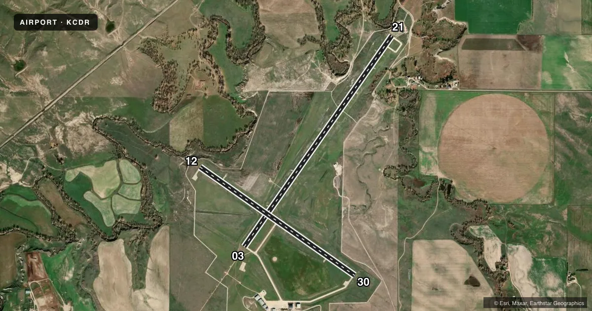
Runways & pattern
Full pagePattern entry · RWY 03
LEFT TRAFFIC| Runway | Heading (°M) | Length | Surface | Traffic |
|---|---|---|---|---|
| 03/21Favored | 28° / 208° | 5,998 ft | CONC | Standard L |
| 12/30 | 118° / 298° | 4,400 ft | CONC | Standard L |
Runway end performance
| End | TORA | TODA | ASDA | LDA | VGSI | Approach lights | Obstruction |
|---|---|---|---|---|---|---|---|
| 03 | 5,998' | 5,998' | 5,500' | 5,211' | VASI 4-box left(3°) | MALSR | — |
| 21 | 5,998' | 5,998' | 5,500' | 5,500' | VASI 4-box left(3°) | — | 14', brush, 331' from thr, 426' R of cntrln, slope 9 |
| 12 | 4,400' | 4,400' | 4,400' | 4,400' | PAPI 4-box left(3°) | — | 15', trees, 936' from thr, 169' R of cntrln, slope 49 |
| 30 | 4,400' | 4,400' | 4,400' | 4,400' | PAPI 4-box left(3°) | — | 35', road, 1400' from thr, 220' R of cntrln, slope 34 |
Declared distances in feet. TORA = takeoff run available, TODA = takeoff distance, ASDA = accelerate-stop, LDA = landing distance.
Airport sketch
Runways drawn to scale from FAA survey coordinates, rendered over satellite imagery. Not for navigation.
Approaches & charts
ILS · 1
Services on the field
Fuel grades, oxygen, maintenance, ramp storage and lighting — as declared to the FAA by the airport operator.
Fuel & services
- Fuel
- 100LLA
- Airframe repair
- Major
- Power plant repair
- Major
- Other services
- CHTR
Ramp & ground
- Transient storage
- Tie-down
- Hangar
- Landing fee
- No fee published
- Customs
- Not available
- Lighting schedule
- SEE RMK
- Beacon schedule
- SS-SR
- Beacon
- White / Green (civil land)(WG)
- Wind indicator
- Lighted
- Segmented circle
- Yes
Fuel & FBOs
Cheapest 100LL and Jet A on the field and nearby. Always confirm with the FBO before taxi.
Airport notes
Surface conditions, obstructions, local procedures, lighting outages and other notes published with each FAA cycle.
General notes
- FOR CD IF UNA TO CTC ON FSS FREQ, CTC DENVER ARTCC AT 303-651-4257.
Lighting notes
- ACTVT HIRL RY 03/21 & MIRL RY 12/30; REIL RY 21 & RY 30 ; PAPI RYS 12/30; VASI RYS 03/21; MALSR RY 03 - CTAF.
Approach & departure obstructions
- 03APCH RATIO 45:1 FM DSPLCD THR.
Other notes
- MANAGERROGER STEVENS ON SITE AIRPORT OPERATIONS SUPERVISOR. ARPT OFFICE 308-615-9007
VFR map & nearby airports
VFR sectional. Tap any ICAO chip to open that airport.
Key facts · KCDR
Answer card- ICAO
- KCDR
- Name
- CHADRON MUNI
- Location
- CHADRON, NEBRASKA
- Elevation
- 3,297.8 ft MSL
- Traffic pattern altitude
- 4,297.8 ft MSL (1,000 AGL)
- Control tower
- Non-towered (use CTAF)
- Total runways
- 2
- Longest runway
- 03/21 · 5,998 ft
- Published ILS approaches
- 1
- Published frequencies
- 2
- Magnetic variation
- 7°
- Current flight rules
- VFR
- Current wind
- 050° at 5 kt
- Favored runway now
- RWY 03
Chadron Muni sits in Chadron, Nebraska. Field elevation is 3,297.8 ft MSL. The airport has 2 concrete runways. The longest is runway 03/21 at 5,998 ft. There is no control tower, so plan to use CTAF 122.8 for self-announce traffic. The published pattern altitude is not listed, so use the standard 1,000 ft AGL for light piston operations unless the current Chart Supplement says otherwise.
One ILS approach is published for runway 03. That matters here because runway 03 also has medium intensity approach lighting with runway alignment indicator lights. Runway 03/21 has high intensity runway lighting. Runway 12/30 has medium intensity runway lighting. Runway end identifier lights are installed on runways 21 and 30. PAPI is installed on runways 12 and 30. VASI is installed on runways 03 and 21.
The on-field FBO is Chadron Municipal Airport. It carries 100LL and Jet A. The airport operations supervisor is Roger Stevens. The airport office phone number is 308-615-9007. For a first-time arrival, pay attention to the field elevation and local density altitude. This is a higher-elevation airport, so takeoff and climb performance deserve a close look. Also note the published obstacle note for runway 03. The approach slope from the displaced threshold is 45 to 1. Check the current Chart Supplement before departure for any updated operating notes.