METAR & TAF 9V5
9V5 does not publish a METAR.
Showing the nearest reporting station: KGRN (GORDON MUNI) · 12.6 NM away. Conditions at 9V5 may differ.
METAR · KGRN
Observed 04:35Z
KGRN 270435Z AUTO 00000KT 10SM CLR 24/14 A2995 RMK AO2 T02420136
- Wind
- 000° @ 0 kt
- Visibility
- 10 SM
- Temp / Dew
- 24°C / 14°C
- Altimeter
- 29.95 inHg
- Clouds
- CLR
- Density alt
- 5,694 ft
- Ceiling
- Unlimited
- Rules
- VFR
Airport info & contacts
Manager on record, flight service, ARTCC, attendance schedule and pattern altitude — published by the FAA and refreshed every 28 days.
Location
- From city
- 2 NM NE
- VFR sectional
- CHEYENNE
- ARTCC
- ZDV · DENVER
- NOTAM facility
- OLU (NOTAM-D)
Airport manager
- Name
- BRAD YOUNKIN
- Phone
- 308-360-2219
- Address
- PO BOX 99, RUSHVILLE NE 69360-0099
Flight service · Hours
- FSS OLU
- COLUMBUS1-800-WX-BRIEF
- Attendance
- Unattended
Frequencies
Tap any row to copy the frequency to your clipboard.
Runways & pattern
Full pagePattern entry · RWY 14
LEFT TRAFFICRunway end performance
| End | TORA | TODA | ASDA | LDA | VGSI | Approach lights | Obstruction |
|---|---|---|---|---|---|---|---|
| 14 | — | — | — | — | PAPI 2-box left(3°) | — | 5', fence, 400' from thr, 0' R of cntrln, slope 40 |
| 32 | — | — | — | — | PAPI 2-box left(3°) | — | 18', tree, 414' from thr, 275' R of cntrln, slope 12 |
Declared distances in feet. TORA = takeoff run available, TODA = takeoff distance, ASDA = accelerate-stop, LDA = landing distance.
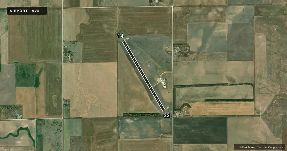
Airport sketch
Runways drawn to scale from FAA survey coordinates, rendered over satellite imagery. Not for navigation.
Approaches & charts
Services on the field
Fuel grades, oxygen, maintenance, ramp storage and lighting — as declared to the FAA by the airport operator.
Fuel & services
- Fuel
- 100LL
- Oxygen (bottled)
- Not available
- Oxygen (bulk)
- Not available
- Airframe repair
- Not available
- Power plant repair
- Not available
Ramp & ground
- Transient storage
- Tie-down
- Hangar
- Landing fee
- No fee published
- Customs
- Not available
- Lighting schedule
- SEE RMK
- Beacon schedule
- SS-SR
- Beacon
- White / Green (civil land)(WG)
- Wind indicator
- Lighted
- Segmented circle
- Yes
Fuel & FBOs
Cheapest 100LL and Jet A on the field and nearby. Always confirm with the FBO before taxi.
Airport notes
Surface conditions, obstructions, local procedures, lighting outages and other notes published with each FAA cycle.
General notes
- NUMEROUS CROP DUSTING ACFT INVOF ARPT.
- WILDLIFE ON & INVOF ARPT.
- COURTESY CAR AVBL.
- FOR CD CTC DENVER ARTCC AT 303-651-4257.
Lighting notes
- ACTVT MIRL RY 14/32; PAPI AND REIL RYS 14 & 32 - CTAF.
Fuel notes
- 100LLAVBL H24 VIA CREDIT CARD.
Other notes
- CALL AHD FOR TSNT HNGR AVBLTY.
- MANAGERRUSHVILLE CITY OFC.
VFR map & nearby airports
VFR sectional. Tap any ICAO chip to open that airport.
Key facts · 9V5
Answer card- ICAO
- 9V5
- Name
- MODISETT
- Location
- RUSHVILLE, NEBRASKA
- Elevation
- 3,751.3 ft MSL
- Traffic pattern altitude
- 4,751.3 ft MSL (1,000 AGL)
- Control tower
- Non-towered (use CTAF)
- Total runways
- 1
- Longest runway
- 14/32 · 3,909 ft
- Published ILS approaches
- 0
- Published frequencies
- 1
- Magnetic variation
- 8°
- Current flight rules
- VFR
- Current wind
- 000° at 0 kt
- Favored runway now
- –
MODISETT Airport (9V5) sits in Rushville, Nebraska. Field elevation is 3,751.3 ft MSL. The airport has one runway. Runway 14/32 is 3,909 ft long with concrete pavement. The field is non-towered. CTAF 122.9 is the working frequency for self-announce traffic. No ILS approaches are published here.
Pattern altitude is not published in the facts block. Use the standard 1,000 ft AGL unless the current Chart Supplement says otherwise. That puts the light piston pattern at about 4,751.3 ft MSL. The airport sits in a part of western Nebraska where crop dusting traffic is common. Expect that activity in the area. Wildlife is also reported on and near the field.
Rushville Airport Authority is the on-field FBO. It carries 100LL. 24-hour credit card fuel is available. A courtesy car is available. Call ahead if you need transient hangar space. Runway lighting is medium intensity on 14/32. PAPI and runway end identifier lights are published for both runway ends. For clearance delivery, contact Denver Air Route Traffic Control Center. If you are planning a first visit, brief the pattern well, watch for ag traffic and use the current Chart Supplement for any details not listed here.