METAR & TAF 4V6
4V6 does not publish a METAR.
Showing the nearest reporting station: KCDR (CHADRON MUNI) · 19.7 NM away. Conditions at 4V6 may differ.
METAR · KCDR
Observed 05:13Z
KCDR 270513Z AUTO 35010KT 10SM FEW070 SCT090 31/11 A2995 RMK AO2 WSHFT 0453 LTG DSNT N AND NE T03060111
- Wind
- 350° @ 10 kt
- Visibility
- 10 SM
- Temp / Dew
- 31°C / 11°C
- Altimeter
- 29.95 inHg
- Clouds
- SCT
- Density alt
- 6,633 ft
- Ceiling
- Unlimited
- Rules
- VFR
Airport info & contacts
Manager on record, flight service, ARTCC, attendance schedule and pattern altitude — published by the FAA and refreshed every 28 days.
Location
- From city
- 0 NM SW
- VFR sectional
- CHEYENNE
- ARTCC
- ZDV · DENVER
- NOTAM facility
- OLU (NOTAM-D)
Airport manager
- Name
- SAMANTHA ORR
- Phone
- 308-638-7275
- Address
- P.O. BOX B, HAY SPRINGS NE 69347-0534
Flight service · Hours
- FSS OLU
- COLUMBUS1-800-WX-BRIEF
- Attendance
- Unattended
Frequencies
Tap any row to copy the frequency to your clipboard.
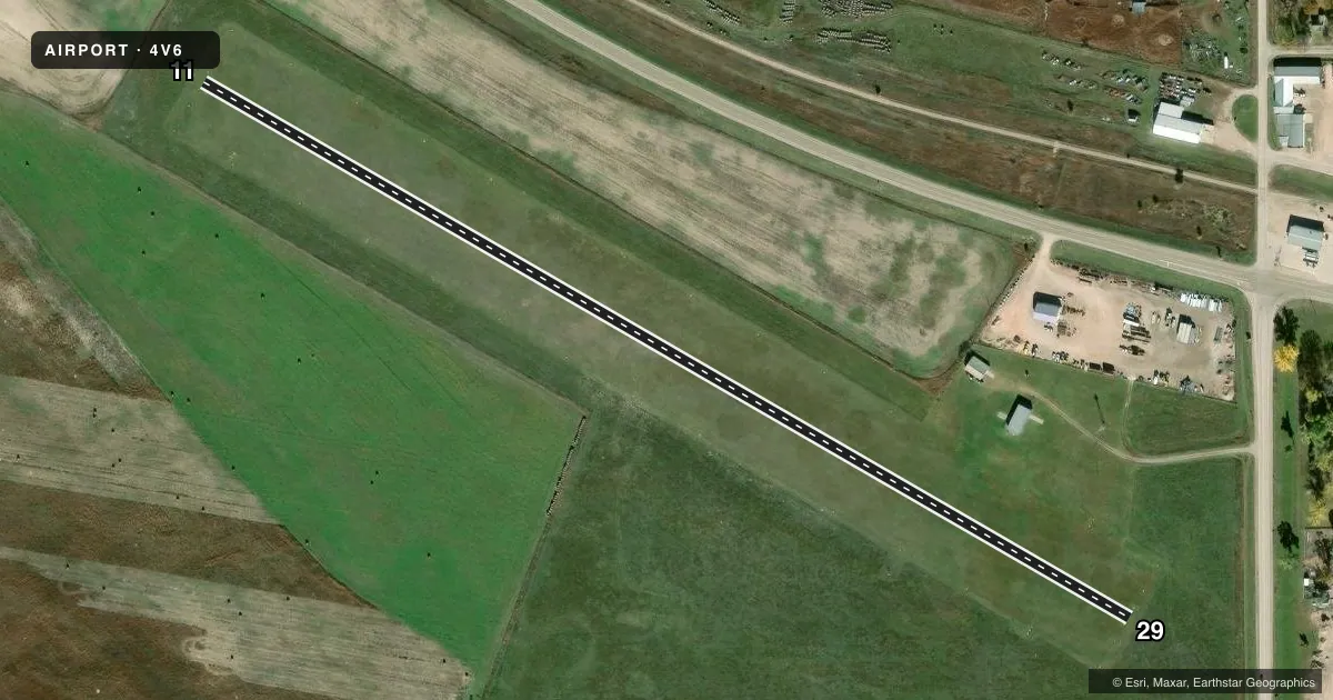
Runways & pattern
Full pagePattern entry · RWY 29
LEFT TRAFFICRunway end performance
| End | TORA | TODA | ASDA | LDA | VGSI | Approach lights | Obstruction |
|---|---|---|---|---|---|---|---|
| 29 | — | — | — | — | — | — | 38', pole, 654' from thr, 143' R of cntrln, slope 17 |
Declared distances in feet. TORA = takeoff run available, TODA = takeoff distance, ASDA = accelerate-stop, LDA = landing distance.
Airport sketch
Runways drawn to scale from FAA survey coordinates, rendered over satellite imagery. Not for navigation.
Approaches & charts
Services on the field
Fuel grades, oxygen, maintenance, ramp storage and lighting — as declared to the FAA by the airport operator.
Fuel & services
- Fuel
- Not available
- Oxygen (bottled)
- Not available
- Oxygen (bulk)
- Not available
- Airframe repair
- Not available
- Power plant repair
- Not available
Ramp & ground
- Transient storage
- Tie-down
- Landing fee
- No fee published
- Customs
- Not available
- Lighting schedule
- SEE RMK
- Beacon schedule
- SEE RMK
- Beacon
- White / Green (civil land)(WG)
- Wind indicator
- Yes
- Segmented circle
- No
Fuel & FBOs
Cheapest 100LL and Jet A on the field and nearby. Always confirm with the FBO before taxi.
Airport notes
Surface conditions, obstructions, local procedures, lighting outages and other notes published with each FAA cycle.
General notes
- FOR CD CTC DENVER ARTCC AT 303-651-4257.
Lighting notes
- ACTVT ROTG BCN - CTAF.
- ACTVT MIRL RY 11/29 - CTAF.
Approach & departure obstructions
- 11RY 11/29 MARKED WITH YELLOW CONES AROUND LGTS.
- 29APCH RATIO 22:1 TO DSPLCD THLD.
VFR map & nearby airports
VFR sectional. Tap any ICAO chip to open that airport.
Key facts · 4V6
Answer card- ICAO
- 4V6
- Name
- HAY SPRINGS MUNI
- Location
- HAY SPRINGS, NEBRASKA
- Elevation
- 3,831 ft MSL
- Traffic pattern altitude
- 4,831 ft MSL (1,000 AGL)
- Control tower
- Non-towered (use CTAF)
- Total runways
- 1
- Longest runway
- 11/29 · 2,775 ft
- Published ILS approaches
- 0
- Published frequencies
- 1
- Magnetic variation
- –
- Current flight rules
- VFR
- Current wind
- 350° at 10 kt
- Favored runway now
- RWY 29
Hay Springs Muni (4V6) sits in Hay Springs, Nebraska. The field elevation is 3,831 ft MSL. It has one runway. Runway 11/29 is 2,775 ft of turf, so plan for a short-field surface and check performance carefully. There is no control tower. CTAF is 122.9.
No ILS approaches are published here. Pattern altitude is not published. Use the standard 1,000 ft AGL pattern unless the current Chart Supplement says otherwise. The airport remarks matter here. Runway lights on 11/29 are activated by CTAF. The rotating beacon is also CTAF-activated. The runway is marked with yellow cones around the lights. There is also a published 22:1 approach slope ratio to the displaced threshold on runway 29, so watch your glide path on arrival.
There are no on-field FBOs listed, so plan ahead for services and fuel. Check with the airport operator or call the field on CTAF for current availability before you go. For clearance delivery, contact Denver ARTCC at 303-651-4257. At this elevation, density altitude can matter a lot in warm weather. Give yourself room for takeoff and landing performance.