METAR & TAF KGRN
Current METAR
Observed 14:55Z
KGRN 271455Z AUTO 11004KT 10SM CLR 32/15 A2998 RMK AO2 T03160154
- Wind
- 110° @ 4 kt
- Visibility
- 10 SM
- Temp / Dew
- 32°C / 15°C
- Altimeter
- 29.98 inHg
- Clouds
- CLR
- Density alt
- 6,383 ft
- Ceiling
- Unlimited
- Rules
- VFR
Airport info & contacts
Manager on record, flight service, ARTCC, attendance schedule and pattern altitude — published by the FAA and refreshed every 28 days.
Location
- From city
- 1 NM E
- VFR sectional
- CHEYENNE
- ARTCC
- ZDV · DENVER
- NOTAM facility
- OLU (NOTAM-D)
Airport manager
- Name
- GLEN SPAUGH
- Phone
- 308-282-0837
- Address
- PO BOX 310, GORDON NE 69343-0310
Flight service · Hours
- FSS OLU
- COLUMBUS1-800-WX-BRIEF
- Attendance
- MON-FRI · 0800-1700
Frequencies
Tap any row to copy the frequency to your clipboard.
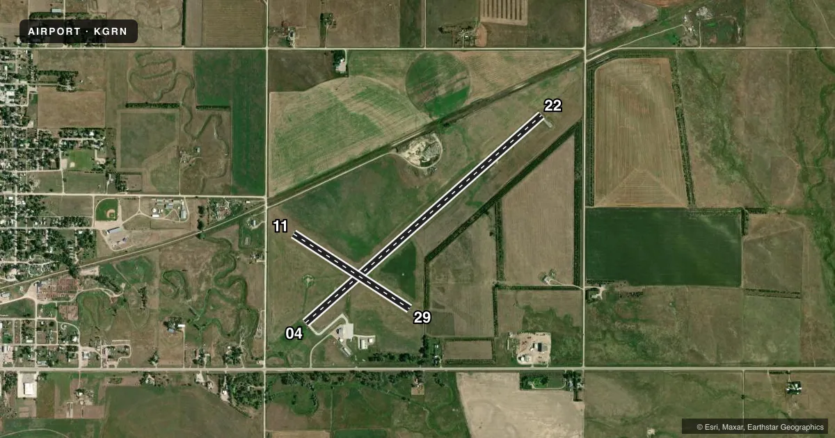
Runways & pattern
Full pagePattern entry · RWY 11
LEFT TRAFFIC| Runway | Heading (°M) | Length | Surface | Traffic |
|---|---|---|---|---|
| 04/22 | 40° / 220° | 5,196 ft | ASPH | Standard L |
| 11/29Favored | 114° / 294° | 2,283 ft | ASPH | Standard L |
Runway end performance
| End | TORA | TODA | ASDA | LDA | VGSI | Approach lights | Obstruction |
|---|---|---|---|---|---|---|---|
| 04 | — | — | — | — | PAPI 2-box left(3°) | — | 57', trees, 1213' from thr, 197' R of cntrln, slope 17 |
| 22 | — | — | — | — | PAPI 2-box left(3°) | — | 21', road, 673' from thr, 0' R of cntrln, slope 22 |
| 11 | — | — | — | — | — | — | 15', road, 433' from thr, 0' R of cntrln, slope 15 |
| 29 | — | — | — | — | — | — | 3', fence, 222' from thr, 127' R of cntrln, slope 7 |
Declared distances in feet. TORA = takeoff run available, TODA = takeoff distance, ASDA = accelerate-stop, LDA = landing distance.
Airport sketch
Runways drawn to scale from FAA survey coordinates, rendered over satellite imagery. Not for navigation.
Approaches & charts
Services on the field
Fuel grades, oxygen, maintenance, ramp storage and lighting — as declared to the FAA by the airport operator.
Fuel & services
- Fuel
- 100LL
- Oxygen (bottled)
- Not available
- Oxygen (bulk)
- Not available
- Other services
- INSTR
Ramp & ground
- Transient storage
- Tie-down
- Hangar
- Landing fee
- No fee published
- Customs
- Not available
- Lighting schedule
- SEE RMK
- Beacon schedule
- SS-SR
- Beacon
- White / Green (civil land)(WG)
- Wind indicator
- Lighted
- Segmented circle
- No
Fuel & FBOs
Cheapest 100LL and Jet A on the field and nearby. Always confirm with the FBO before taxi.
Airport notes
Surface conditions, obstructions, local procedures, lighting outages and other notes published with each FAA cycle.
General notes
- FOR CD CTC DENVER ARTCC AT 303-651-4257.
Lighting notes
- ACTVT REIL RWY 04 & 22; MIRL RWY 4/22 & 11/29 - CTAF. PAPI RWY 04 & 22 OPR CONSLY.
Fuel notes
- 100LLAVGAS AVBL.
Runway surface & condition
- 11/29MARKINGS FADED.
Other notes
- ESTABLISHED PRIOR TO 1959.
- 1FOR SVC AFTER HRS CALL 308-360-1906 OR 308-360-2120.
- OWNERMARK KRUGER (605) 840-0177.
- INSTRINSTR PART-TIME; HANGAR OVERNIGHT; COURTESY CAR.
- 11/29WEEDS IN PAVEMENT; MED & HIGH SEVERITY CRACKS IN PAVEMENT.
VFR map & nearby airports
VFR sectional. Tap any ICAO chip to open that airport.
Key facts · KGRN
Answer card- ICAO
- KGRN
- Name
- GORDON MUNI
- Location
- GORDON, NEBRASKA
- Elevation
- 3,562.4 ft MSL
- Traffic pattern altitude
- 4,562.4 ft MSL (1,000 AGL)
- Control tower
- Non-towered (use CTAF)
- Total runways
- 2
- Longest runway
- 04/22 · 5,196 ft
- Published ILS approaches
- 0
- Published frequencies
- 2
- Magnetic variation
- 9°
- Current flight rules
- VFR
- Current wind
- 110° at 4 kt
- Favored runway now
- RWY 11
Gordon Muni sits in Gordon, Nebraska. The field elevation is 3,562.4 ft MSL. It has two asphalt runways. The longest is 5,196 ft on runway 04/22. There is no control tower. CTAF and UNICOM are both 122.8. No ILS approaches are published.
Pattern altitude is not published. Use the standard 1,000 ft AGL pattern unless the current Chart Supplement or local traffic calls for something different. The airport has one on-field FBO listed as Gordon Municipal Airport. It carries AVGAS 100LL. Call ahead at (308) 282-0837 for current service details.
Published remarks matter here. Runway 04 and 22 have active runway end identifier lights. Medium intensity runway lights are installed on both runways and are controlled by CTAF. The PAPI on 04 and 22 operates continuously. Runway 11/29 has faded markings. It also has weeds in the pavement plus medium and high severity cracks. That makes the longer strip the better bet for most arrivals. For clearance delivery, contact Denver ARTCC at 303-651-4257. Instruction is available part-time. Hangar overnight and courtesy car service are also listed.