METAR & TAF KHSR
KHSR does not publish a METAR.
Showing the nearest reporting station: KCUT (CUSTER COUNTY) · 24.1 NM away. Conditions at KHSR may differ.
METAR · KCUT
Observed 10:53Z
KCUT 271053Z AUTO VRB03KT 10SM -RA FEW044 BKN110 17/14 A3015 RMK AO2 WSHFT 0940 LTG DSNT E AND SE RAE12B38 TSE39 SLP131 P0012 T01720144 $
- Wind
- VAR @ 3 kt
- Visibility
- 10 SM
- Temp / Dew
- 17°C / 14°C
- Altimeter
- 30.15 inHg
- Clouds
- BKN
- Density alt
- 3,861 ft
- Ceiling
- 11,000 ft AGL
- Rules
- VFR
Airport info & contacts
Manager on record, flight service, ARTCC, attendance schedule and pattern altitude — published by the FAA and refreshed every 28 days.
Location
- From city
- 5 NM SE
- VFR sectional
- CHEYENNE
- ARTCC
- ZDV · DENVER
- NOTAM facility
- HON (NOTAM-D)
Airport manager
- Name
- IVAN VENNER
- Phone
- 605-295-1535
- Address
- 27858 HWY 385, HOT SPRINGS SD 57747
Flight service · Hours
- FSS HON
- HURON1-800-WX-BRIEF
- Attendance
- MON-FRI · 0800-1700
Frequencies
Tap any row to copy the frequency to your clipboard.
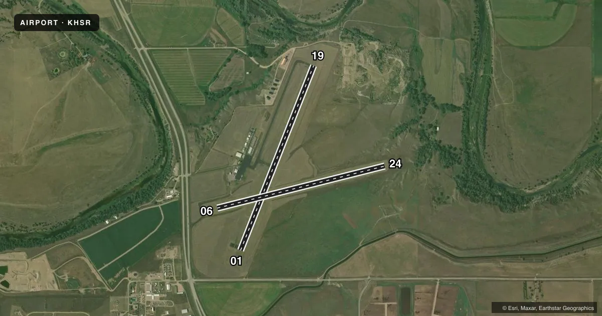
Runways & pattern
Full pagePattern entry · RWY 01
LEFT TRAFFIC| Runway | Heading (°M) | Length | Surface | Traffic |
|---|---|---|---|---|
| 01/19Favored | 12° / 192° | 4,506 ft | ASPH | Standard L |
| 06/24 | 66° / 246° | 3,926 ft | TURF | Standard L |
Runway end performance
| End | TORA | TODA | ASDA | LDA | VGSI | Approach lights | Obstruction |
|---|---|---|---|---|---|---|---|
| 01 | — | — | — | — | PAPI 2-box left(3°) | — | 122', trees, 3400' from thr, 0' R of cntrln, slope 26 |
| 19 | — | — | — | — | PAPI 2-box left(3°) | — | 20', tree, 601' from thr, 280' R of cntrln, slope 20 |
Declared distances in feet. TORA = takeoff run available, TODA = takeoff distance, ASDA = accelerate-stop, LDA = landing distance.
Airport sketch
Runways drawn to scale from FAA survey coordinates, rendered over satellite imagery. Not for navigation.
Approaches & charts
Services on the field
Fuel grades, oxygen, maintenance, ramp storage and lighting — as declared to the FAA by the airport operator.
Fuel & services
- Fuel
- 100LL
- Oxygen (bottled)
- Not available
- Oxygen (bulk)
- Not available
- Airframe repair
- Major
- Power plant repair
- Major
- Other services
- AGRI,GLD,TOW
Ramp & ground
- Transient storage
- Tie-down
- Hangar
- Landing fee
- No fee published
- Customs
- Not available
- Lighting schedule
- SEE RMK
- Beacon schedule
- SS-SR
- Beacon
- White / Green (civil land)(WG)
- Wind indicator
- Lighted
- Segmented circle
- Yes
Fuel & FBOs
Cheapest 100LL and Jet A on the field and nearby. Always confirm with the FBO before taxi.
Airport notes
Surface conditions, obstructions, local procedures, lighting outages and other notes published with each FAA cycle.
General notes
- RY 01 +21 FT PLINE 680 FT FM THR.
- BIRDS ON & INVOF ARPT.
- RY 06/24 MARKED WITH BLACK AND WHITE CONES.
- GLIDER OPS ON & INVOF ARPT.
- GCO AVBL ON FREQ 121.725 ( 4 CLICKS TO DENVER CENTER AND 6 CLIKCS TO FLIGHT SERVICES)
- COMPASS ROSE LCTD ON APRON.
- FOR CD IF UNA VIA GCO CTC DENVER ARTCC AT 303-651-4257.
- HIGH VOL OF ACFT OPRNG INVOF OF MT RUSHMORE AND CRAZY HORSE MONUMENTS AT OR BLW 7500 FT; PILOTS ARE ADVISED TO MNT 122.85 FOR TFC ADVISORIES.
Lighting notes
- ACTVT PAPI RWY 01 & 19; MIRL RWY 01/19 - CTAF.
Fuel notes
- 100LLFUEL AVBL 24 HRS WITH CREDIT CARD.
Other notes
- AUTOMATED UNICOM; 3 CLICKS ADZY & WX.
VFR map & nearby airports
VFR sectional. Tap any ICAO chip to open that airport.
Key facts · KHSR
Answer card- ICAO
- KHSR
- Name
- HOT SPRINGS MUNI
- Location
- HOT SPRINGS, SOUTH DAKOTA
- Elevation
- 3,150.2 ft MSL
- Traffic pattern altitude
- 4,150.2 ft MSL (1,000 AGL)
- Control tower
- Non-towered (use CTAF)
- Total runways
- 2
- Longest runway
- 01/19 · 4,506 ft
- Published ILS approaches
- 0
- Published frequencies
- 2
- Magnetic variation
- 10°
- Current flight rules
- VFR
- Current wind
- 000° at 3 kt
- Favored runway now
- RWY 01
Hot Springs Muni sits in Hot Springs, South Dakota. The field elevation is 3,150.2 ft MSL. It has two runways. The longest is runway 01/19 at 4,506 ft asphalt. Runway 06/24 is 3,926 ft turf. There is no control tower. CTAF and UNICOM are both 122.8. No ILS approaches are published.
Pattern altitude is not published. For light piston operations, use the standard 1,000 ft AGL pattern unless the current Chart Supplement or local traffic calls for something different. The field is in a busy Black Hills area. Published remarks call out glider activity on and near the airport. Birds are also reported in the area. That means a good traffic scan matters on arrival and departure.
The on-field FBO is Hot Springs Municipal Airport. It carries 100LL. Fuel is available 24 hours with credit card. Runway 01 and runway 19 have PAPI. Medium intensity runway lights are on 01 and 19. They are controlled by CTAF. Runway 06/24 is marked with black and white cones. There is also a plus 21 ft power line 680 ft from the threshold of runway 01. If you are planning a clearance, GCO is on 121.725. The remarks also note heavy traffic near Mount Rushmore and Crazy Horse Monuments at or below 7,500 ft. Monitor 122.85 for traffic advisories in that area.