METAR & TAF 6V0
6V0 does not publish a METAR.
Showing the nearest reporting station: KCUT (CUSTER COUNTY) · 28.1 NM away. Conditions at 6V0 may differ.
METAR · KCUT
Observed 11:53Z
KCUT 271153Z AUTO 30004KT 10SM CLR 17/15 A3014 RMK AO2 RAE17 SLP127 P0001 60018 70037 T01670150 10206 20161 58003 $
- Wind
- 300° @ 4 kt
- Visibility
- 10 SM
- Temp / Dew
- 17°C / 15°C
- Altimeter
- 30.14 inHg
- Clouds
- CLR
- Density alt
- 4,423 ft
- Ceiling
- Unlimited
- Rules
- VFR
Airport info & contacts
Manager on record, flight service, ARTCC, attendance schedule and pattern altitude — published by the FAA and refreshed every 28 days.
Location
- From city
- 1 NM SW
- VFR sectional
- CHEYENNE
- ARTCC
- ZDV · DENVER
- NOTAM facility
- HON (NOTAM-D)
Airport manager
- Name
- CITY OF EDGEMONT
- Phone
- 605-662-7422
- Address
- PO BOX A, EDGEMONT SD 57735
Flight service · Hours
- FSS HON
- HURON1-800-WX-BRIEF
- Attendance
- Unattended
Frequencies
Tap any row to copy the frequency to your clipboard.
Runways & pattern
Full pagePattern entry · RWY 30
LEFT TRAFFIC| Runway | Heading (°M) | Length | Surface | Traffic |
|---|---|---|---|---|
| 12/30Favored | 122° / 302° | 3,900 ft | ASPH | Standard L |
| 16/34 | 162° / 343° | 2,016 ft | TURF | Standard L |
Runway end performance
| End | TORA | TODA | ASDA | LDA | VGSI | Approach lights | Obstruction |
|---|---|---|---|---|---|---|---|
| 12 | — | — | — | — | PAPI 2-box left(3°) | — | — |
| 30 | — | — | — | — | PAPI 2-box left(3°) | — | — |
| 16 | — | — | — | — | — | — | 24', bldg, 507' from thr, 120' R of cntrln, slope 21 |
| 34 | — | — | — | — | — | — | 5', fence, 100' from thr, 0' R of cntrln, slope 20 |
Declared distances in feet. TORA = takeoff run available, TODA = takeoff distance, ASDA = accelerate-stop, LDA = landing distance.
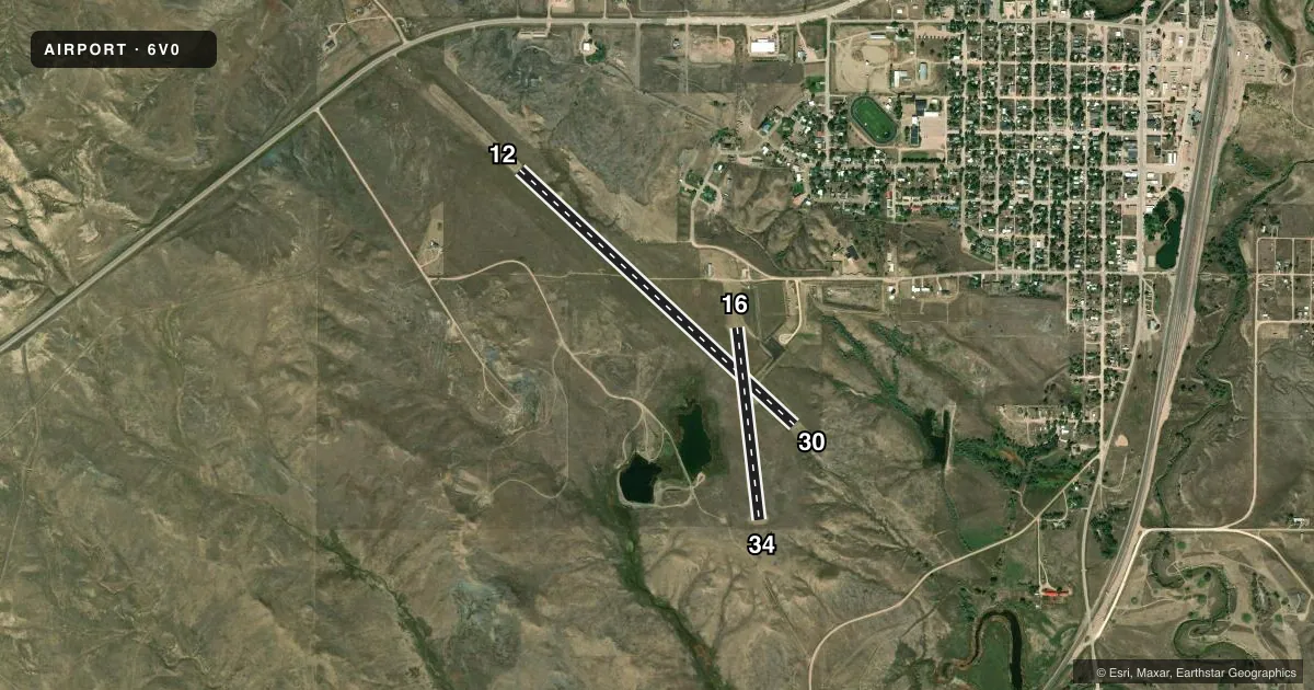
Airport sketch
Runways drawn to scale from FAA survey coordinates, rendered over satellite imagery. Not for navigation.
Approaches & charts
Services on the field
Fuel grades, oxygen, maintenance, ramp storage and lighting — as declared to the FAA by the airport operator.
Fuel & services
- Fuel
- Not available
- Oxygen (bottled)
- Not available
- Oxygen (bulk)
- Not available
- Airframe repair
- Not available
- Power plant repair
- Not available
Ramp & ground
- Transient storage
- Tie-down
- Landing fee
- No fee published
- Customs
- Not available
- Lighting schedule
- SEE RMK
- Beacon schedule
- SS-SR
- Beacon
- White / Green (civil land)(WG)
- Wind indicator
- Lighted
- Segmented circle
- Yes
Fuel & FBOs
Cheapest 100LL and Jet A on the field and nearby. Always confirm with the FBO before taxi.
Airport notes
Surface conditions, obstructions, local procedures, lighting outages and other notes published with each FAA cycle.
General notes
- WILDLIFE ON & INVOF ARPT.
- ULTRALGT ACTVTY ON & INVOF ARPT.
- FOR CD CTC DENVER ARTCC AT 303-651-4257.
Lighting notes
- ACTVT PAPI RWY 12 & 30: MIRL RWY 12/30 - CTAF.
Other notes
- EXISTED PRIOR TO 1959.
VFR map & nearby airports
VFR sectional. Tap any ICAO chip to open that airport.
Key facts · 6V0
Answer card- ICAO
- 6V0
- Name
- EDGEMONT MUNI
- Location
- EDGEMONT, SOUTH DAKOTA
- Elevation
- 3,593.6 ft MSL
- Traffic pattern altitude
- 4,593.6 ft MSL (1,000 AGL)
- Control tower
- Non-towered (use CTAF)
- Total runways
- 2
- Longest runway
- 12/30 · 3,900 ft
- Published ILS approaches
- 0
- Published frequencies
- 1
- Magnetic variation
- 11°
- Current flight rules
- VFR
- Current wind
- 300° at 4 kt
- Favored runway now
- RWY 30
Edgemont Muni sits in Edgemont, South Dakota. Field elevation is 3,593.6 ft MSL. The airport has two runways. The longest is runway 12/30 at 3,900 ft of asphalt. Runway 16/34 is 2,016 ft of turf. There is no control tower. CTAF is 122.9.
No ILS approaches are published here. Pattern altitude is not published, so use the standard 1,000 ft AGL for light piston traffic unless the current Chart Supplement says otherwise. That puts the traffic pattern at about 4,593.6 ft MSL based on the field elevation. Runway 12 and 30 have active PAPI. Medium intensity runway lighting is installed on those runways. Use the CTAF for airport traffic. For clearance delivery, contact Denver ARTCC at 303-651-4257.
There are no on-field FBOs listed in the facts, so plan ahead for services before you arrive. The published remarks also note wildlife on and near the airport. Ultralight activity occurs there too. This is a small non-towered field with a high-elevation setting, so expect density altitude to matter on warm days. Check the current Chart Supplement before flight for any current remarks or operational changes.