METAR & TAF 9V6
9V6 does not publish a METAR.
Showing the nearest reporting station: KGRN (GORDON MUNI) · 29.6 NM away. Conditions at 9V6 may differ.
METAR · KGRN
Observed 12:55Z
KGRN 271255Z AUTO 00000KT 10SM CLR 21/14 A2998 RMK AO2 T02070142
- Wind
- 000° @ 0 kt
- Visibility
- 10 SM
- Temp / Dew
- 21°C / 14°C
- Altimeter
- 29.98 inHg
- Clouds
- CLR
- Density alt
- 4,731 ft
- Ceiling
- Unlimited
- Rules
- VFR
Airport info & contacts
Manager on record, flight service, ARTCC, attendance schedule and pattern altitude — published by the FAA and refreshed every 28 days.
Location
- From city
- 1 NM SE
- VFR sectional
- CHEYENNE
- ARTCC
- ZDV · DENVER
- NOTAM facility
- HON (NOTAM-D)
Airport manager
- Name
- PAUL NOEL
- Phone
- 605-685-4361
- Address
- MARTIN SD 57551
Flight service · Hours
- FSS HON
- HURON1-800-WX-BRIEF
- Attendance
- Unattended
Frequencies
Tap any row to copy the frequency to your clipboard.
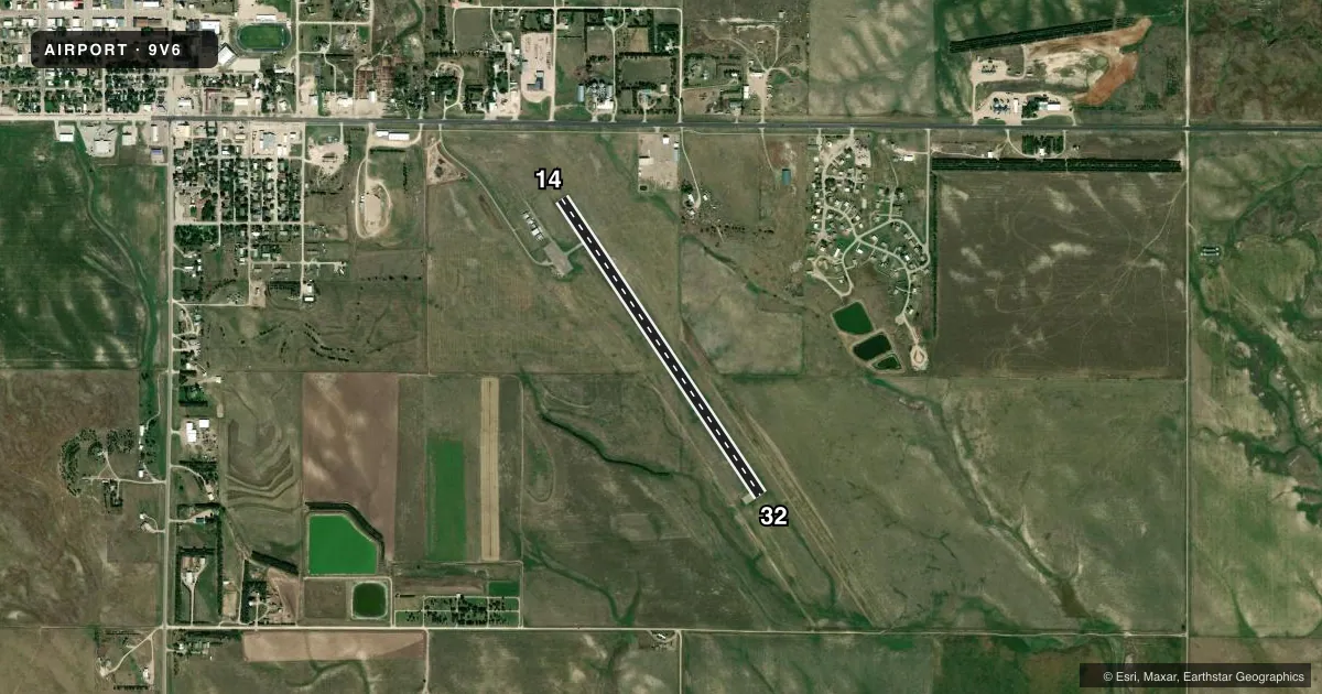
Runways & pattern
Full pagePattern entry · RWY 14
LEFT TRAFFICRunway end performance
| End | TORA | TODA | ASDA | LDA | VGSI | Approach lights | Obstruction |
|---|---|---|---|---|---|---|---|
| 14 | — | — | — | — | PAPI 2-box left(3°) | — | — |
| 32 | — | — | — | — | PAPI 2-box left(3°) | — | — |
Declared distances in feet. TORA = takeoff run available, TODA = takeoff distance, ASDA = accelerate-stop, LDA = landing distance.
Airport sketch
Runways drawn to scale from FAA survey coordinates, rendered over satellite imagery. Not for navigation.
Approaches & charts
Services on the field
Fuel grades, oxygen, maintenance, ramp storage and lighting — as declared to the FAA by the airport operator.
Fuel & services
- Fuel
- Not available
- Oxygen (bottled)
- Not available
- Oxygen (bulk)
- Not available
- Airframe repair
- Not available
- Power plant repair
- Not available
- Other services
- AGRI
Ramp & ground
- Transient storage
- Tie-down
- Landing fee
- No fee published
- Customs
- Not available
- Lighting schedule
- SEE RMK
- Beacon schedule
- SS-SR
- Beacon
- White / Green (civil land)(WG)
- Wind indicator
- Lighted
- Segmented circle
- No
Fuel & FBOs
Cheapest 100LL and Jet A on the field and nearby. Always confirm with the FBO before taxi.
Airport notes
Surface conditions, obstructions, local procedures, lighting outages and other notes published with each FAA cycle.
General notes
- WILDLIFE ON AND INVOF ARPT
- FOR CD CTC DENVER ARTCC AT 303-651-4257.
Lighting notes
- ACTVT PAPI RWY 14 & 32, MIRL RWY 14/32 - 122.900.
VFR map & nearby airports
VFR sectional. Tap any ICAO chip to open that airport.
Key facts · 9V6
Answer card- ICAO
- 9V6
- Name
- MARTIN MUNI
- Location
- MARTIN, SOUTH DAKOTA
- Elevation
- 3,294.5 ft MSL
- Traffic pattern altitude
- 4,294.5 ft MSL (1,000 AGL)
- Control tower
- Non-towered (use CTAF)
- Total runways
- 1
- Longest runway
- 14/32 · 3,699 ft
- Published ILS approaches
- 0
- Published frequencies
- 1
- Magnetic variation
- 6°
- Current flight rules
- VFR
- Current wind
- 000° at 0 kt
- Favored runway now
- –
MARTIN MUNI sits in Martin, South Dakota. The field elevation is 3,294.5 ft MSL. It has one runway. Runway 14/32 is 3,699 ft long with asphalt pavement. The airport is not towered. CTAF is 122.9.
No ILS approaches are published here. The pattern altitude is not published in the facts, so plan on the standard 1,000 ft AGL for light piston operations unless the current Chart Supplement says otherwise. The published remarks also note PAPI on runways 14 and 32. Medium intensity runway lights are installed on both ends. Wildlife is reported on and near the airport. Keep a sharp scan on taxi, takeoff and final.
There are no on-field FBOs listed in the facts. Contact the airport operator directly or call the field on CTAF for current service availability before you go. For clearance delivery, contact Denver ARTCC at 303-651-4257. With a single 3,699 ft runway and no published ILS, this is a straightforward VFR field. The elevation means performance planning matters. Check density altitude, runway condition and winds before departure. If you need current operational details, verify them in the current FAA Chart Supplement.