METAR & TAF KPHP
Current METAR
Observed 12:55Z
KPHP 271255Z AUTO 28004KT 10SM CLR 27/16 A2989 RMK AO2 SLP092 T02670161
- Wind
- 280° @ 4 kt
- Visibility
- 10 SM
- Temp / Dew
- 27°C / 16°C
- Altimeter
- 29.89 inHg
- Clouds
- CLR
- Density alt
- 4,217 ft
- Ceiling
- Unlimited
- Rules
- VFR
Airport info & contacts
Manager on record, flight service, ARTCC, attendance schedule and pattern altitude — published by the FAA and refreshed every 28 days.
Location
- From city
- 3 NM E
- VFR sectional
- CHEYENNE
- ARTCC
- ZDV · DENVER
- NOTAM facility
- PHP (NOTAM-D)
Airport manager
- Name
- BRITTANY SMITH
- Phone
- 605-859-2175
- Address
- PO BOX 408, PHILIP SD 57567
Flight service · Hours
- FSS HON
- HURON1-800-WX-BRIEF
- Attendance
- Unattended
Frequencies
Tap any row to copy the frequency to your clipboard.
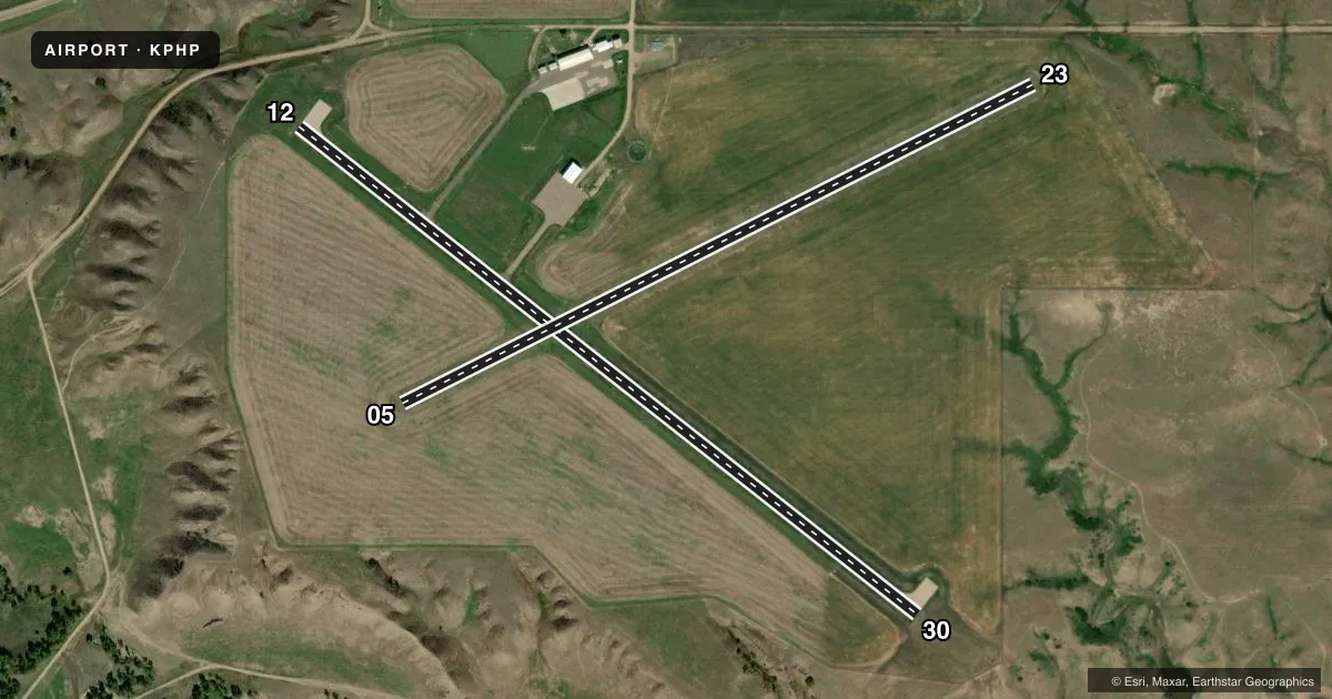
Runways & pattern
Full pagePattern entry · RWY 30
LEFT TRAFFIC| Runway | Heading (°M) | Length | Surface | Traffic |
|---|---|---|---|---|
| 12/30Favored | 121° / 301° | 3,998 ft | ASPH | Standard L |
| 05/23 | 56° / 236° | 3,588 ft | TURF | Standard L |
Runway end performance
| End | TORA | TODA | ASDA | LDA | VGSI | Approach lights | Obstruction |
|---|---|---|---|---|---|---|---|
| 12 | — | — | — | — | PAPI 2-box left(3°) | — | 31', pole, 922' from thr, 0' R of cntrln, slope 23 |
| 30 | — | — | — | — | PAPI 2-box left(3°) | — | — |
Declared distances in feet. TORA = takeoff run available, TODA = takeoff distance, ASDA = accelerate-stop, LDA = landing distance.
Airport sketch
Runways drawn to scale from FAA survey coordinates, rendered over satellite imagery. Not for navigation.
Approaches & charts
Services on the field
Fuel grades, oxygen, maintenance, ramp storage and lighting — as declared to the FAA by the airport operator.
Fuel & services
- Fuel
- 100LL
- Oxygen (bottled)
- Not available
- Oxygen (bulk)
- Not available
- Airframe repair
- Not available
- Power plant repair
- Not available
- Other services
- AGRI
Ramp & ground
- Transient storage
- Tie-down
- Hangar
- Landing fee
- No fee published
- Customs
- Not available
- Lighting schedule
- SEE RMK
- Beacon schedule
- SS-SR
- Beacon
- White / Green (civil land)(WG)
- Wind indicator
- Lighted
- Segmented circle
- Yes
Fuel & FBOs
Cheapest 100LL and Jet A on the field and nearby. Always confirm with the FBO before taxi.
Airport notes
Surface conditions, obstructions, local procedures, lighting outages and other notes published with each FAA cycle.
General notes
- FOR CD IF UNA TO CTC ON FSS FREQ, CTC DENVER ARTCC AT 303-651-4257.
Lighting notes
- ACTIVATE PAPI RY 12/30; MIRL RY 12/30 - CTAF.
Fuel notes
- 100LLFUEL AVBL 24 HRS WITH CREDIT CARD.
Approach & departure obstructions
- 0505/23 MARKED WITH BLACK/WHITE CONES
VFR map & nearby airports
VFR sectional. Tap any ICAO chip to open that airport.
Key facts · KPHP
Answer card- ICAO
- KPHP
- Name
- PHILIP
- Location
- PHILIP, SOUTH DAKOTA
- Elevation
- 2,209.2 ft MSL
- Traffic pattern altitude
- 3,209.2 ft MSL (1,000 AGL)
- Control tower
- Non-towered (use CTAF)
- Total runways
- 2
- Longest runway
- 12/30 · 3,998 ft
- Published ILS approaches
- 0
- Published frequencies
- 2
- Magnetic variation
- 7°
- Current flight rules
- VFR
- Current wind
- 280° at 4 kt
- Favored runway now
- RWY 30
Philip Airport sits in Philip, South Dakota at 2,209.2 ft MSL. It has two runways. The longest is 12/30 at 3,998 ft asphalt. Runway 05/23 is 3,588 ft turf. There is no control tower. CTAF and UNICOM are both 122.8. No ILS approaches are published here. The pattern altitude is not published. Use the standard 1,000 ft AGL pattern unless local guidance says otherwise.
For lighting, the PAPI on runway 12/30 and the medium intensity runway lights on 12/30 are activated on CTAF. Runway 05/23 is marked with black and white cones. Philip Airport carries AVGAS 100LL through the on-field FBO, Philip Airport. Fuel is available 24 hours with a credit card. If you need clearance delivery and cannot reach Flight Service, the published contact is Denver ARTCC.
This is a non-towered field with one paved runway and one turf runway. Watch your spacing and make your CTAF calls early. The field elevation is high enough that density altitude can matter, especially on warm days. Check the current FAA Chart Supplement for any additional local procedures before you go.