METAR & TAF 8F6
8F6 does not publish a METAR.
Showing the nearest reporting station: KSUO (ROSEBUD SIOUX TRIBAL) · 36.2 NM away. Conditions at 8F6 may differ.
METAR · KSUO
Observed 12:35Z
KSUO 271235Z AUTO 00000KT 10SM CLR 25/19 A2989 RMK AO2
- Wind
- 000° @ 0 kt
- Visibility
- 10 SM
- Temp / Dew
- 25°C / 19°C
- Altimeter
- 29.89 inHg
- Clouds
- CLR
- Density alt
- 4,052 ft
- Ceiling
- Unlimited
- Rules
- VFR
Airport info & contacts
Manager on record, flight service, ARTCC, attendance schedule and pattern altitude — published by the FAA and refreshed every 28 days.
Location
- From city
- 3 NM S
- VFR sectional
- OMAHA
- ARTCC
- ZMP · MINNEAPOLIS
- NOTAM facility
- HON (NOTAM-D)
Airport manager
- Name
- JAKE LOLLEY
- Phone
- 605-669-2272
- Address
- PO BOX 432, MURDO SD 57559
Flight service · Hours
- FSS HON
- HURON1-800-WX-BRIEF
- Attendance
- Unattended
Frequencies
Tap any row to copy the frequency to your clipboard.
Runways & pattern
Full pagePattern entry · RWY 14
LEFT TRAFFICRunway end performance
| End | TORA | TODA | ASDA | LDA | VGSI | Approach lights | Obstruction |
|---|---|---|---|---|---|---|---|
| 32 | — | — | — | — | — | — | 8', fence, 390' from thr, 0' R of cntrln, slope 23 |
Declared distances in feet. TORA = takeoff run available, TODA = takeoff distance, ASDA = accelerate-stop, LDA = landing distance.
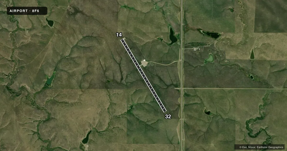
Airport sketch
Runways drawn to scale from FAA survey coordinates, rendered over satellite imagery. Not for navigation.
Approaches & charts
Services on the field
Fuel grades, oxygen, maintenance, ramp storage and lighting — as declared to the FAA by the airport operator.
Fuel & services
- Fuel
- Not available
- Oxygen (bottled)
- Not available
- Power plant repair
- Not available
- Other services
- AGRI
Ramp & ground
- Transient storage
- Tie-down
- Landing fee
- No fee published
- Customs
- Not available
- Lighting schedule
- SEE RMK
- Beacon schedule
- SS-SR
- Beacon
- White / Green (civil land)(WG)
- Wind indicator
- Lighted
- Segmented circle
- Yes
Fuel & FBOs
Cheapest 100LL and Jet A on the field and nearby. Always confirm with the FBO before taxi.
Airport notes
Surface conditions, obstructions, local procedures, lighting outages and other notes published with each FAA cycle.
General notes
- WILDLIFE ON & INVOF ARPT.
- FOR CD CTC MINNEAPOLIS ARTCC AT 651-463-5588.
Lighting notes
- ACTVT MIRL RWY 14 & 32 KEY CTAF 5 TIMES.
VFR map & nearby airports
VFR sectional. Tap any ICAO chip to open that airport.
Key facts · 8F6
Answer card- ICAO
- 8F6
- Name
- MURDO MUNI
- Location
- MURDO, SOUTH DAKOTA
- Elevation
- 2,270.1 ft MSL
- Traffic pattern altitude
- 3,270.1 ft MSL (1,000 AGL)
- Control tower
- Non-towered (use CTAF)
- Total runways
- 1
- Longest runway
- 14/32 · 4,000 ft
- Published ILS approaches
- 0
- Published frequencies
- 2
- Magnetic variation
- 9°
- Current flight rules
- VFR
- Current wind
- 000° at 0 kt
- Favored runway now
- –
Murdo Muni (8F6) sits in Murdo, South Dakota. The field elevation is 2,270.1 ft MSL. It has one runway. Runway 14/32 is 4,000 ft of asphalt, so plan your performance with the elevation in mind. There is no control tower. CTAF and UNICOM are both 122.8.
No ILS approaches are published here. The pattern altitude is not published. Use the standard 1,000 ft AGL pattern unless local procedure or the current FAA Chart Supplement says otherwise. For a light piston, that puts you around 3,270 ft MSL. The published remarks matter here. Wildlife is reported on and near the airport. Runway lights on 14 and 32 are activated by keying the CTAF five times. For clearance delivery, contact Minneapolis ARTCC at 651-463-5588.
There are no on-field FBOs listed in the facts. Contact the airport operator directly before arrival, or call the field on CTAF or UNICOM for current FBO availability. Murdo is a non-towered field with a single runway, so keep your radio work tight and watch for traffic. The elevation is high enough that density altitude can matter on warm days. Verify current airport details in the FAA Chart Supplement before you go.